OCR Text |
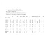
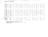
Show Table 6.- Drillers' logs of selected wells and test holes Altitudes are in feet above mean sea level for land surface at well; determined for interpolation from topographic maps. Thickness in feet. Depth in feet below the land surface. Stratigraphy by Claud H. Baker, Jr. Material Thickness Depth Material Thickness Depth Thickness Depth SUMMIT COUNTY ( A- l- 4) 33dbb- l, Log by Inter- mountain Drilling Corp., 1965. Alt. 6,980 ft. Topsoil 7 Sandstone [ Nugget Sandstone] ... 11 Limestone, hard 3 Sandstone 22 Cemented rocks 122 Silt [ siltstone(?) ] 45 Sand [ sandstone (?) ] 25 Silt and sand ( siltstone and sandstone) 110 Reddish hardpan [ Chinle Forma- tion(?)] 19 ( A- l- 15) 20abc- l. Log by J. H. Peterson, 1962. Alt. 5,910 ft. Surface soil 6 Boulders 17 Clay and gravel, gray 10 Clay, gray, hard 16 Clay, blue and gray, with some limestone [ Twin Creek Limestone]. 6 Clay, blue and gray, hard 27 Limestone, broken . . 33 ( D- l- 3) 10aab- l. Log by J. G. Lee, 1966. Alt. 6,640 ft. Boulders and clay 79 Conglomerate 91 Limestone [ Twin Creek Limestone] . 25 Shale 16 Limestone 35 Shale with streaks of limestone. . 146 Conglomerate [ fractured limestone (?)] 44 Shale 5 ( D- l- 3) 10cdb- l. Log by J. G. Lee, 19" 64~: AltT 6,650 ft. Topsoil 1 Boulders 49 Limestone [ Twin Creek Limestone] . 133 Shale and limestone 217 ( D- l- 3) 13adb- l. Log by Inter- mountain Drilling Corp., 1965. Alt. 6,330 ft. Clay and cobbles 5 Clay and sand 10 Sand 10 18 21 43 165 210 235 345 3 64 82 115 79 170 195 211 246 392 43 6 441 50 183 400 ( D- l- 3) 13adb- l - continued Clay and gravel, red [ Chinle Formation(?)] 6 31 Clay, red 49 80 Gravel 10 90 Clay, red 23 113 Gravel 1 114 Clay, red 104 218 Gravel 7 225 Clay, red ... 25 250 ( D- l- 4) 10cbd- l. Log by E. C. Osborne, 1963. Alt. 6,580 ft. Soil 5 5 Sand and gravel 9 14 Clay and silt 67 81 Silt, sand, and gravel 13 94 Andesite, red and gray [ Tertiary rocks] 144 238 ( D- l- 4) 16aad- l. Log by J. S. Lee, 1964. Alt. 6,440 ft. Topsoil 3 3 Clay, brown 9 12 Sand, fine 1 13 Clay, gray 37 50 Clay, sandy and gravelly, brown [ weathered Tertiary volcanic rocks (?)] 112 162 Clay, red, sticky 29 191 Clay and gravel 19 210 Clay, red, sticky 10 220 Clay and gravel, red 30 250 Clay, brown, sticky 15 265 Clay and gravel 15 280 Clay, red and brown 10 290 Clay and gravel 10 300 Clay, red, sticky 8 308 Boulders and gravel, hard 3 311 Clay, red, sticky 9 320 Clay and gravel, brown 14 334 Gravel, some clay 6 340 Clay, brown, sticky 8 348 Hard rock 7 355 Clay and gravel, brown, sticky . . 13 368 Clay, red 22 390 Clay, brown 10 400 Conglomerate [ Knight Conglomerate] 40 440 Clay, brown 10 450 Conglomerate 14 464 Conglomerate, sandy 204 668 ( D- l- 4) 17bbb- l. Log by M. A. Gale, 1950. Alt. 6,620 ft. Topsoil 2 Clay and gravel, red 25 Clay and shale gravel, cream colored 7 Shale, limy; and limestone [ Twin Creek Limestone] 41 Sandstone 1 Limy shale, as above 51 ( D- l- 4) 21aaa- l. Log by J. G. Lee, 1964. Alt. 6,580 ft. Topsoil 12 Andesite [ Tertiary volcanic rocks]. 211 Quartzite and red shale 37 Andesite 27 Porphyry 197 Shale, red [ Woodside Shale] .... 7 Shale, blue 2 Shale, red 61 ( D- 2- 4) 2cbd- l. Log by E. C. Osborne, 1964. Alt. 6,640 ft. Soil 3 Clay 16 Andesite [ Tertiary volcanic rocks] 40 Clay, moist 6 Andesite, red 82 Andesite, gray 63 Shale, red [ Ankareh Formation] . . 6 Sandstone, gray 4 ( D- 2- 6) 19abc- l. Log by J. H. Turner, 1947. Alt. 6,410 ft. Old well [ alluvial fill] 29 Clay, yellow 6 Sand, brown 3 Sandstone, gray; water bearing [ Weber Quartzite] 29 ( D- 2- 6) 19bcc- l. Log by Lester Binning, 1964. Alt. 6,460 ft. Clay 10 Clay and sand 15 Sand 5 Clay and gravel, hard 10 Porphyry [ Tertiary volcanic rocks]. 35 Porphyry and clay 35 223 2 60 287 484 491 493 554 147 210 216 220 WASATCH COUNTY ( D- 2- 5) 20bcb- l. Log by A. Lyons, 1944. Alt. 6,080 ft. Andesite, light gray to yellow [ Tertiary volcanic rocks] . . . . Altered andesite, with serpentine and chlorite Clay, blue, sticky; altered andesite; water 100 140 ( D- 2- 5) 32bad- l. Log by T. J. Burkhart and J. S. Lee, 1943. Alt. 5,965 ft. Surface fill 36 Boulders and gravel 10 Andesite lava [ Tertiary volcanic rocks ] 150 Shale [ Ankareh Formation(?) ] . . 10 ( D- 2- 5) 32bbc- 2. Log by J. H. Peterson, 1950. Alt. 5,850 ft. Surface fill 16 196 206 ( D- 2- 5) 32bbc- 2 - continued Gravel, boulders, and clay . . . . Porphyry [ Tertiary volcanic rocks]. Quartz ( D- 3- 4) 35dab- l. Log by J. G. Lee, 1960. Alt. 5,530 ft. Topsoil " Volcanic ash and cinders" [ tufa] Gravel . Limestone [ tufa] Sand and gravel 145 150 68 |