Contents | 26 of 52
Page 26


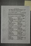
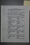
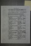
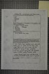
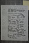
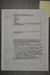
| Title | James L. Patton Field Notes 2015 |
| Creator | James L. Patton |
| Description | Field notes for James L. Patton covering collecting activities from 2015 |
| Subject | Zoology Collector Notes |
| Date | 2015 |
| Spatial Coverage | Utah |
| Format | application/pdf |
| Language | eng |
| ARK | ark:/87278/s6063947 |
| Setname | umnh_fn |
| ID | 1669914 |
| Reference URL | https://collections.lib.utah.edu/ark:/87278/s6063947 |
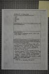
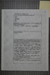
Page Metadata
| Title | Page 26 |
| Format | application/pdf |
| Setname | umnh_fn |
| ID | 1669940 |
| Reference URL | https://collections.lib.utah.edu/ark:/87278/s6063947/1669940 |