| OCR Text |
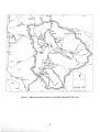
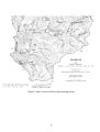
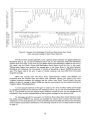
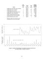
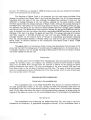
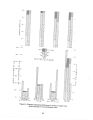
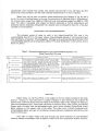
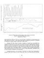
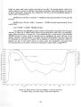
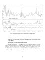
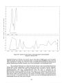
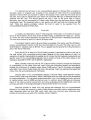
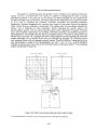
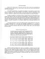
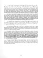
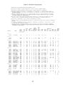
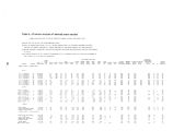
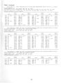
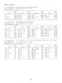
Show " i i i i i i i i i i i i i i i i i i r ( D - 1 - 6 ) 1 9 d a d - 1 NORTH END RHODES VALLEY 4 - MIDDLE RHODES VALLEY 6 - ( D- 2- 6) 20ccc- 1 SOUTH END RHODES VALLEY J I I I I I I I L III l l l l l l i i i i _ L L 93839 40 41 42 43 44 45 46 47 4 8 49 50 51 52 53 54 55 56 57 58 59 60 61 62 63 64 65 66 671968 Figure 16.- Graphs of water levels in selected wells in Rhodes Valley. 25,000 acres x 50 feet x 0.66 x 15 percent = 120,000 acre- feet ( approximately) for the lower 50 feet; Total: 190,000 + 120,000 = about 310,000 acre- feet. Discharge.- Ground water is discharged from the unconsolidated deposits in Rhodes Valley by evapotranspiration and by seepage into Beaver Creek, Weber River, and Provo River. Because the hydrologic regimen in the valley is stable, the minimum long- term average annual discharge probably is about equal to the minimum average annual recharge of 22,000 acre- feet. The net annual evapotranspiration loss of ground water, in acre- feet, from Rhodes Valley is calculated as follows: 40 |