| OCR Text |
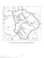
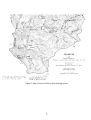
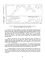
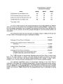
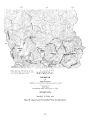
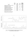
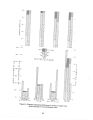
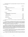
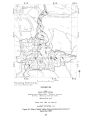
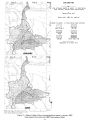
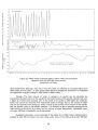
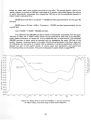
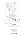
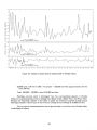
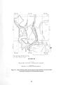
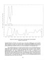
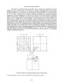
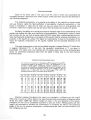
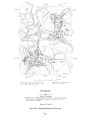
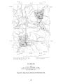
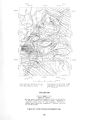
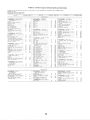
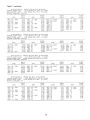
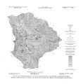
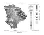
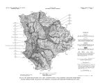
Show Acre- feet Total irrigation diversion 44,000 Precipitation + 13,000 Total 57,000 Less crop water requirement - 40,000 Difference ( available for recharge) 17,000 Total recharge 22,000 Less recharge from irrigation - 17,000 Difference ( recharge from other sources, primarily subsurface inflow) 5,000 Movement.- In most of Rhodes Valley, ground water moves toward Beaver Creek ( fig. 15); in the north end of the valley, in the vicinity of the Weber River, ground water moves toward the river. In the south end of Rhodes Valley, near the bluff overlooking the Provo River, some ground water moves toward the bluff and the Provo River. The ground- water divide, separating water that moves toward the Weber River from water that moves toward the Provo River, is only a short distance north of the bluff ( fig. 15). Apparently the divide can exist so near the bluff because of the difference between lateral and vertical permeability of the aquifer. The bedding, like the land surface, slopes gently northward from the edge of the bluff. Hence water moving northward to the Weber River and Beaver Creek moves laterally through the beds, but water moving toward the Provo River moves vertically across the beds. The lateral permeability of alluvial deposits is commonly greater than the vertical permeability. It is calculated that if water has equal opportunity to move in either direction from the ground- water divide, and if the ratio of lateral to vertical permeability is 140 to 1- within the range reported for bedded deposits ( Bennett and others, 1967, p. G53)- the divide will be stable at about the position indicated in figure 15. Water- level fluctuations.- Graphs of three wells in Rhodes Valley that have been measured since 1938 are shown in figure 16. All three graphs show the annual fluctuations that are typical of water- table aquifers in permeable valley- fill material that is irrigated with diverted surface water. The well at Oakley, in the north end of the valley, fluctuates through a much greater range than either of the two wells farther south. Although there is considerable variation between the highest or lowest water levels in adjacent years, there is no marked long- term departure from the average high or low. The graphs indicate a relatively stable recharge- discharge relation, with little evidence of long- term net change. Storage.- The total volume of water theoretically recoverable from storage in the upper 100 feet of valley fill in Rhodes Valley can be calculated by the same method used for Heber Valley. If the saturated valley fill is at least 50 feet thick under the entire valley, and at least 100 feet thick under two- thirds of the valley, then the recoverable water in storage is: 25,000 acres x 50 feet x 15 percent = 190,000 acre- feet ( approximately) for the upper 50 feet; and • 38 |