| OCR Text |
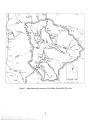
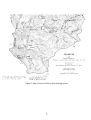
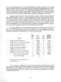
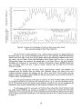
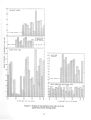
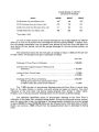
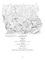
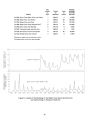
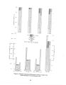
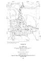
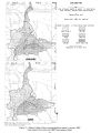
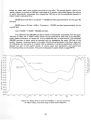
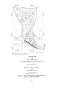
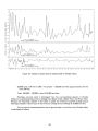
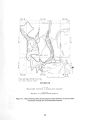
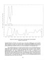
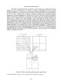
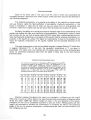
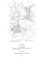
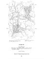
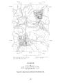
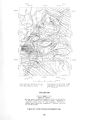
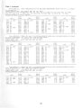
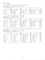
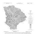
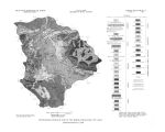
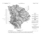
Show A GRAVITY AND AEROMAGNETIC SURVEY OF HEBER AND RHODES VALLEYS, UTAH BY D. L. Peterson Geologist, U. S. Geological Survey A gravity survey was made in Heber and Rhodes Valleys to aid in determining the approximate thickness of valley fill and to help interpret bedrock configuration. Observations were made at about 130 locations in the valleys and at a few locations in the nearby Wasatch Range and Uinta Mountains with a Worden gravimeter with a sensitivity of about 0.5 milligal per scale division. Horizontal and vertical positions for most of the observations were taken from benchmarks and other points of known elevations located on U. S. Geological Survey 1: 24,000 scale topographic maps. Elevations for 23 observations were determined by altimetry. Two altimeters were read at points easily recognized on topographic maps and the average of the two readings was used in the computations. Loops were made from points of known elevation. The readings were corrected for changes in air density and are considered accurate to within 10 feet. A density of 2.67 grams per cubic centimeter was assumed in reducing the data to the complete Bouguer anomaly. Theoretical gravity was computed from the International formula. The observed gravity values were referenced to base station WU 29 at Liberty Park, Salt Lake City, Utah ( Behrendt and Wool lard, 1961). Terrain corrections were computed through zone K using Hayford- Bowie templates ( Swick, 1942) for 44 stations. Terrain corrections for the remaining stations were interpolated from a contour map of the 44 terrain correction values. The relative accuracy of complete Bouguer gravity values thus obtained is about 0.5 milligal, except for gravity stations with elevations determined by altimetry which may be in error by 1.0 milligal. An unpublished Master's thesis, " A regional gravity survey of the back valleys of the Wasatch Mountains and adjacent areas in Utah, Idaho, and Wyoming," by Robert P. Quitzau reports on gravity observations in this area made by students at the University of Utah. Dr. Kenneth L. Cook made a copy of this thesis available to the U. S. Geological Survey. None of the gravity data from the thesis were used in preparing the maps presented here, but the data were useful in designing the gravity survey, interpolating terrain corrections, and defining the regional gravity field. The complete Bouguer gravity map ( fig. 20) shows an eastward decrease in the regional gravity field which is interpreted as being related mainly to features of greater extent than the local valleys. An assumed regional gravity field was determined by contouring gravity values for stations on or near exposures of pre- Tertiary bedrock. A residual Bouguer gravity map ( fig. 21) was perpared by removing the assumed regional gravity field from the Bouguer gravity map. The residual Bouguer gravity map shows a 4- milligal low in Heber Valley and an 8- milligal low in Rhodes Valley. The low in Heber Valley is approximately coextensive with the valley with the lowest values in the southwest. The steeper gravity gradients along the west and south edges of Heber Valley may reflect faulting. Faulting has been mapped along the south edge of the valley ( Stokes, 1964). The closed gravity low in Rhodes Valley is confined to the northern half of the valley and is bounded by steep gradients, which may reflect faults. In the southern half of Rhodes Valley there is an area of low gravity values continuing south beyond the area of the survey. 54 • |