| OCR Text |
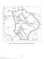
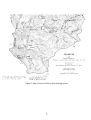
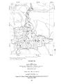
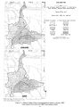
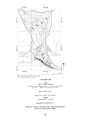
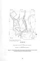
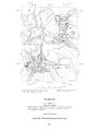
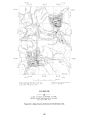
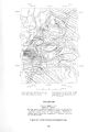
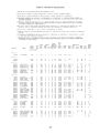
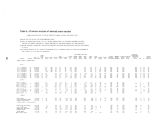
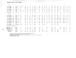
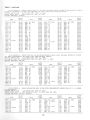
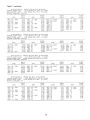
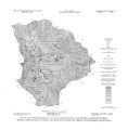
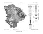
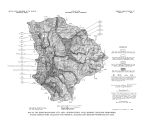
Show It is believed that all water in the unconsolidated deposits in Parleys Park is suitable for domestic, stock, or irrigation use. Analyses of two samples of water from the unconsolidated deposits in Parleys Park are reported in table 5. One sample, from a well near the north end of the park, was a calcium bicarbonate type water and contained 338 mg/ l of dissolved solids; the hardness was 261 mg/ l. The second sample was from a well on the south side of Quarry Mountain, very near an outcropping of Triassic rocks. Water from this well was a calcium sulfate bicarbonate type. The dissolved solids in this sample was 527 mg/ l and the hardness was 398 mg/ l. These two samples probably indicate the kind of water to be expected from the unconsolidated deposits in Parleys Park. Round Valley A roughly oval depression, about 7 miles long and 4 miles wide, in the overthrust ( upper) block of the Charleston thrust fault south of Heber Valley, is called Round Valley ( pi. 1 and fig. 1). Unlike the other valleys described, the valley floor in Round Valley is decidedly bowlshaped. The total area covered by alluvium is about 20 square miles. Two drillers' logs for wells in Round Valley are available. The log for well ( D- 5- 4) 12bba- 1 reports unconsolidated material to 45 feet, the total depth of the well. The other log, for well ( D- 5- 4) 13acd- 1, indicates rock at 38 feet. Thus it appears that the alluvial fill in Round Valley is only a few tens of feet thick. Such alluvial fill as there is in Round Valley, however, is saturated to within a few feet of the land surface with unconfined ground water. Because of the virtual absence of wells, no evaluation of aquifer characteristics is possible, but it is likely that the hydraulic conductivity and specific yield of the unconsolidated deposits here is similar to those of the other valleys in the studyarea- about50 ft3/ d/ ft2 and 15 percent, respectively. Water probably enters the alluvial fill in Round Valley primarily through the infiltration of precipitation on the valley floor and runoff from the surrounding slopes, and secondarily through the infiltration of irrigation water. About 2,580 acres of land in the valley are irrigated with water from Round Valley Creek and from a few springs. There may also be some subsurface inflow from the surrounding Oquirrh Formation. Ground water in the unconsolidated deposits of Round Valley moves generally toward Round Valley Creek and downvalley. Water is discharged into the creek and into the atmosphere by evapotranspiration. The calculated evapotranspiration from the irrigated land and a few acres of marshy bottom lands is 5,000 acre- feet per year. In addition, about 3,300 acres on the lower slopes of the valley are partly covered with such plants as greasewood and rabbitbrush, which use some ground water. The average discharge to Round Valley Creek is not known. Chemical analyses of water from two springs that discharge from the unconsolidated deposits in the valley are reported in table 5. Both samples were dilute calcium bicarbonate type water ( dissolved solids less than 300 mg/ l). Both were very hard but were otherwise quite suitable for domestic use as well as for livestock and for irrigation. 45 |