| OCR Text |
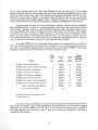
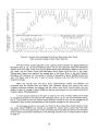
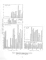
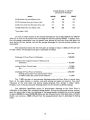
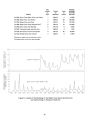
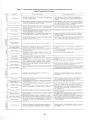
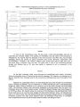
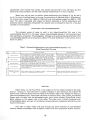
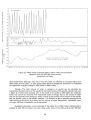
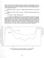
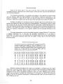
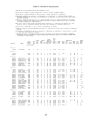
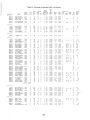
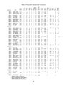
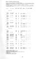
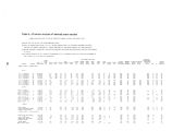
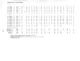
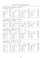
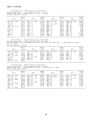
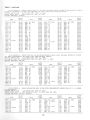
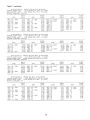
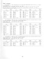
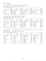
Show The unconsolidated deposits in Rhodes Valley are saturated to within a few feet of the land surface with unconfined ground water. As in Heber Valley, the entire valley fill can be treated as a single water- table aquifer, because neither continuous zones of very high or very low permeability nor areas of artesian conditions are evident. Aquifer characteristics.- Data from drillers' tests of 17 wells in Rhodes Valley ( table 3) yield specific capacities of wells ranging from 0.1 gpm per foot of drawdown to 13 gpm per foot of drawdown. The largest values of specific capacity suggest an aquifer transmissivity of about 3,500 fts/ d/ ft. Aquifer tests have not been performed in Rhodes Valley proper, but tests were conducted by the U. S. Bureau of Reclamation in a well at a damsite in Weber Canyon, a few miles upstream from Rhodes Valley and just outside the study area. Data obtained by the Bureau from 3 pumping tests and 2 recovery tests were analyzed by the writer; the calculated transmissivity was about 5,400 ft3/ d/ ft. The aquifer at the test site is 247 feet thick, giving a calculated hydraulic conductivity of about 22 ft3/ d/ ft2- only about one- half that calculated for the valley fill in Heber Valley. The value of specific yield calculated from the data obtained by the Bureau of Reclamation was about 12 percent. Specific yield was also calculated from drillers' logs of 15 wells in Rhodes Valley by the method used for Heber Valley. The wells ranged in depth from 33 to 78 feet and averaged 68 feet; the estimated values of specific yield averaged about 15 percent, both for the upper 20 feet and for the total thickness penetrated. Recharge.- The unconsolidated deposits in Rhodes Valley are recharged primarily by the infiltration of irrigation water. Some additional recharge comes from the direct infiltration of snowmelt and by subsurface inflow from the surrounding consolidated rocks; probably little or no recharge is received from summer rains. Records of water- level fluctuations are available for only a few wells in Rhodes Valley. Records for about 10 wells in the valley, for various periods before 1950, indicate an average annual change in saturated thickness of about 4 feet in the southern three- fourths of the valley and about 12 feet in the northern one- fourth. This average change in saturated thickness, with an area of 39 square miles ( about 25,000 acres) and a specific yield of 15 percent gives an average annual change in storage of about 22,000 acre- feet of water; hence the minimum average annual recharge is 22,000 acre- feet per year. This value is used as an estimate of the annual recharge in the water- budget study. The amounts of recharge contributed from irrigation water and from other sources were calculated for Rhodes Valley as they were for Heber Valley. Calculation by the Blaney- Criddle method ( Blaney and Criddle, 1962) gives an average crop water requirement for Rhodes Valley of about 40,000 acre- feet per irrigation season. The average total irrigation diversion is about 44,000 acre- feet; the average precipitation on the valley floor during the irrigation season is about 13,000 acre- feet. Thus the amount of recharge from irrigation water is: 37 |