| OCR Text |
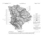
Show Chemical Quality.- All the water sampled from the unconsolidated deposits in Heber Valley was chemically suitable for domestic use, according to the standards of the U. S. Public Health Service, although 2 samples of sulfate type water and 1 sample of mixed type were somewhat above the optimum in dissolved solids, and all samples were hard to very hard. The water is satisfactory for stock or for irrigation. Chemical analyses of 10 samples of water from the unconsolidated deposits in Heber Valley are reported in table 5. The locations from which the samples were collected and diagrammatic representations of the concentrations of the principal dissolved solids in some of the samples are shown on plate 3. Seven of the 10 samples were calcium bicarbonate type water, with dissolved solids ranging from 187 to 446 mg/ l. The hardness of the 7 samples ranged from 144 to 324 mg/ l, in the hard to very hard range. Silica concentration ranged from 12 to 43 mg/ l; the samples that were high in silica came from the east side of the valley, where the rocks forming the valley wall are predominantly volcanic. Two of the 10 samples were calcium sulfate water, and both contained more dissolved solids than the calcium bicarbonate water. One of these samples came from a well at the north end of the valley, very near the outcropping of the Triassic shales, and the water was similar to that found in the shales ( diagram 2, fig. 9). The concentration of dissolved solids of this sample was 727 mg/ l and the hardness was 464 mg/ l. The other sample of sulfate type water came from a well near Midway. That well taps a layer of gravel overlain by tufa, and the water is similar to water from the hot pots, but more dilute. The sample contained 1,160 mg/ l dissolved solids, and the hardness was 770 mg/ l. One of the 10 samples was a calcium bicarbonate sulfate type water. That sample came from a shallow dug well in the tufa deposits near Midway, and the water appears to be a mixture of hot pot type water and the dilute calcium bicarbonate type water commonly found in the valley fill. The concentration of dissolved solids in the sample was 661 mg/ l and the hardness was 434 mg/ l. Rhodes Valley Rhodes Valley, the second largest of the four valleys in the study area, is nearly rectangular in plan, with the long axis of the rectangle oriented about north- south ( pi. 1 and fig. 1). The area of the valley floor is about 39 square miles. The Weber River flows westward across the north end of the valley, entering and leaving through narrow canyons. The principal drainage of the valley is by Beaver Creek, which enters the valley from the east near the south end, flows northwestward, and joins the Weber River where that stream leaves the valley. At the south end, Rhodes Valley terminates in a bluff that overlooks the Provo River. The alluvial fill deposited in Rhodes Valley by the Provo River ( see p. 5- 7) is probably more than 300 feet thick under most of the valley. In addition, a sizeable alluvial fan has been formed where the Weber River enters the valley, and smaller fans mark the mouths of Beaver Creek Canyon and Hoyt Canyon. When the upper Provo River changed course, the stream entrenched itself in its former valley floor. Thus nearly 100 feet of unconsolidated material is exposed in the north side of the Provo Canyon at the south end of Rhodes Valley ( fig. 14a). The material is poorly sorted and only weakly stratified ( fig. 14b). 35 |


