OCR Text |
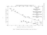
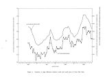
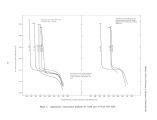
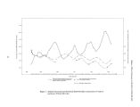
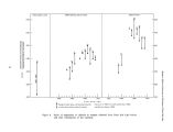
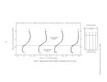
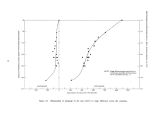
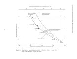
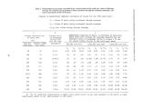
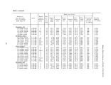
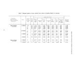
Show Madison- Effects of Causeway on Chemistry of Great Salt Lake from the south part, and evaporation during the seasonal lake cycle was sufficient to further concentrate the brine ( figure 3). Because the causeway acts as a partial dike and because most of the inflow is to the south part, a difference in water- surface altitude across the causeway developed, with the south side being higher ( figure 4). As a result of this altitude difference, the less concentrated brine in the south part moves northward through the upper part of the culverts and fill. Because this brine is less dense, it spreads out over the surface of the north part in a thin sheet and eventually is mixed by wave action. During certain times of the year, when the lake is calm and temperatures are high, some of this less concentrated brine may evaporate before mixing occurs. Concurrently, the difference in densities ( concentration of dissolved solids) between water in the two parts of the lake causes a density head, and the more dense water in the north part moves southward through the bottom section of the culverts and through the fill. Some mixing probably occurs at the interface as brine moves through the causeway, but most of the southward flow drops to the bottom of the south part of the lake and forms a lower layer of brine that is of greater concentration than the rest of the brine in the south part and slightly less concentrated than the brine in the north part. At lake stages between 4,194 feet and 4,197 feet, the lower layer of brine in the south part is about 20 feet below the lake surface. Data collected during this study and by Hahl and Handy ( 1969, figure 1) indicate that the lower layer of brine will be found in all parts of the lake where the lake bottom is below an altitude of about 4,175 feet ( figure 5). The volume of the lower layer of brine appears to remain relatively constant. Samples collected from the lake within a day or two after severe storms indicate that this lower layer of brine does not mix rapidly with the less dense upper layer of brine, even with violent wave action. Mixing probably takes place slowly at the interface. The apparent stability of the lower layer of brine is probably due to the fact that a rough equilibrium exists between the amount of brine moving south through the causeway and the amount of mixing taking place at the interface. In the discussions that follow in later sections of this report, it is assumed that this equilibrium exists. Figure 6 shows the three brine zones and the movement of brine as inferred in and near the causeway. From 1959, when the causeway was completed, until 1963, the lake stage continued a downward trend that had begun in 1952. In 1963, the lake reached an historic low stage of 4,191.35 feet above mean sea level. At this stage the original undivided lake would have reached saturation, and large quantities of sodium chloride probably would have precipitated over the entire lakebed. At some time during the period 1954- 63, therefore, a salt crust of undetermined thickness and extent probably formed on the lakebed north and south of the causeway. The rise in lake stage after 1963 caused a decrease in the concentration of the brine in the south part. If indeed salt had previously been precipitated on the lake bottom, some of the precipitated salt in the south part probably redissolved. However, while the concentration of the brine in the south part was decreasing, the more dense brine in the north part was moving southward through the causeway to form the deeper layer in the south part. Thus some of the precipitated salt may have been trapped under this deeper layer of nearly saturated brine and prevented from redissolving. The salt crust north of the causeway could not redissolve because it was already covered by nearly saturated brine. The total amount of salt that has precipitated on the lakebed is not known, but it may be as much as 25 percent of the salt that was in solution prior to the construction of the causeway. Hahl and Langford ( 1964, p. 25) report that the approximate total load of dissolved salt in both parts of the lake during 1959- 61 was 4.4 billion tons. This compares with about 6 billion tons when the lake was at its highest recorded stage in 1873 ( Handy and Hahl, 1966, p. 140) and about 5.4 billion tons in 1954. Very rough estimates made in 1969 on the basis of only a few chemical analyses gave a total load of dissolved salt for the entire lake of about 4.2 billion tons. Apparently not a great deal of additional salt has precipitated since 1961. With the rising lake levels that have occurred since 1963, the south part ( exclusive of the lower layer) has remained more dilute than the original undivided lake would have been for the same stage, while the north part has remained at or near saturation ( figure 3). Although there are several mechanisms for the loss of salt from solution in closed lakes ( Langbein, 1961, p. 10) and some lost salts are not available for re- solution, probably at least half of the salts lost during the period 1954- 63 remains in a salt crust on the lakebed ( B. F. Jones, oral commun., 1970). 12 |