OCR Text |
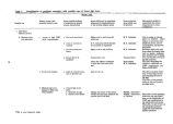
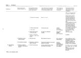
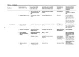
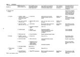
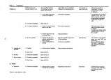
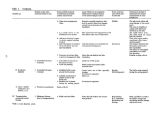
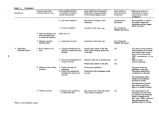
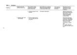
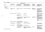
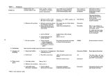
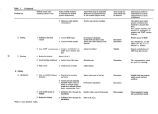
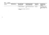
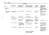
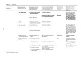
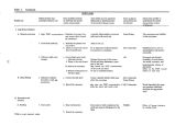
Show Table 9. Research needs identified for the hydrologic system. Research Needs Possible Information Source Group A Methods to control high water damage ( flooding) in both the short and long- term. Establishment of a reliable lake elevation frequency curve. A state of the art prediction of future high and low lake elevation extremes. A better definition of the present water balance including data on:* 1. The spatial variation of evaporation across the lake. 2. The spatial variation of precipitation across the lake. 3. Total groundwater inflow to the lake and its spatial variation ( group B priority). 4. Flow through the railroad causeway fill. 5. Flow through the Antelope Island fill. A better definition of the present salt balance including data on: 1. Flow through the railroad causeway fill. 2. Monitoring of the vertical location of the interface between the south arm brines. 3. The rate of mixing between the two south arm brines. 4. Salinity of groundwater inflows ( group B priority). The forces creating the mixing mechanism between the two south arm brines which also leads to why the south arm is stratified. Data on the present circulation patterns including point velocity measurements. Modification to the circulation patterns which would result from alterations to the physical system such as breaching the railroad causeway, pumping brine to the west desert, or constructing additional dikes and causeway in the lake. Testing of the USGS causeway flow equations for current conditions. This requires fill flow information and may lead to altering the flow equations. Study the mixing of north and south arm brines to prove or disprove that they would mix if the causeway were breached. Future salinity and stratification trends of the lake brines under altered conditions such as breaching the railroad causeway or pumping brine to the west desert and returning the concentrated brine to the north or south arm. Conditions which would cause a precipitated salt layer to be covered with a sediment which would restrict redissolving as the lake rose. Relationship between the hydrology and salinity balance of Farmington Bay and the south arm. DWR, ACE, UWRL DWR, UWRL DWR, UWRL, H. Willett ( MIT) USGS USGS USGS USGS USGS USGS UGMS J. Glassett ( BYU), A. Lin ( U of U), G. Watters ( USU) USGS A. Lin ( U of U), G. Watters ( USU), J. Glassett ( BYU) UGMS, NOAA G. Watters ( USU) USGS J. Glassett ( BYU), A. Lin ( U of U), UGMS, UWRL USGS, DWR, UWRL J. Glassett ( BYU) UGMS, UWRL USGS, DWR, UWRL Group B How the precipitation of salt in the north arm affects the ionic makeup of the lake brines. Vapor pressure, temperature, and wind near the lake ( for use in calculating evaporation). Verification of existing methods or the development of calculating evaporation from the lake. This requires evaporation data from points near or in the lake. J. Jurinak ( USU), UGMS Weather Bureau, USGS USGS Group C The relationship between Great Salt Lake and the climate of the basin including precipitation and temperature. Methods of equalizing the spring and summer inflows to the marsh land. The contribution that condensation of fog makes to the water budget. DWLR, DWR, FWS The USGS basic data collection program also should be continued. 39 |