| Title |
Washington territory: The great North-west, her material resources, and claims to emigration. A plain statement of things as they exist |
| Call Number |
F891 .M5 1865; Record ID 99200190102001 |
| Date |
1865 |
| Description |
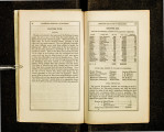
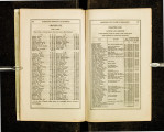
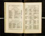
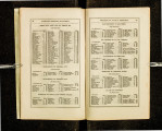
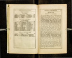
Asa Mercer published his first work when he was twenty-five, as he was arranging for a second emigration party to the Pacific coast. He said later that copies of this work were distributed for free. Mercer served two sessions as the first president of Washington Territorial University. From Washington he moved to Oregon and then finally to Texas. With Washington Territory, Mercer gave a minute account of the territorial boundaries and described the geographical, topographical and sociological features of the region west of the Cascades including climate, agricultural resources, lumber, minerals, fish and fishing, whaling, grazing lands, manufacturing, the markets and trade, Indians, newspapers, schools, and towns. This is the first detailed account of the area after its establishment as a territory, with an appendix of elaborate tables of routes and distances to various mining regions of Idaho and Montana |
| Creator |
Mercer, A. S. ǂq (Asa Shinn), 1839-1917 |
| Publisher |
Digitized by J. Willard Marriott Library, University of Utah |
| Subject |
Washington (State) -- Description and travel; Northwest, Pacific -- Description and travel |
| Type |
Text |
| Format |
application/pdf |
| Identifier |
F891-_M5-1865.pdf |
| Language |
eng |
| Spatial Coverage |
Washington, United States |
| Collection Name |
Rare Books Collection |
| Holding Institution |
Rare Books Division, Special Collections, J. Willard Marriott Library, University of Utah |
| Rights |
 |
| Scanning Technician |
Ellen Moffatt |
| Digitization Specifications |
Original scanned with Hasselblad H2D 39 megapixel digital camera and saved as 600 ppi tiffs. Display images created in Adobe Photoshop Lightroom 5 and generated in Adobe Acrobat ProX as multiple page pdf. |
| ARK |
ark:/87278/s6pg3t9n |
| Setname |
uum_rbc |
| ID |
308945 |
| Reference URL |
https://collections.lib.utah.edu/ark:/87278/s6pg3t9n |