| OCR Text |
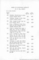
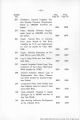
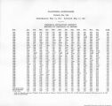
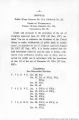
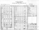
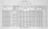
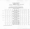
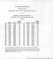
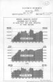
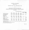
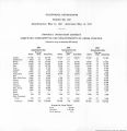
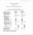
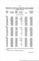
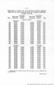
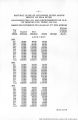
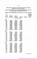
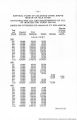
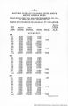
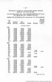
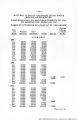
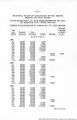
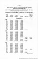
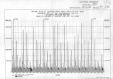
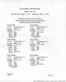
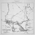
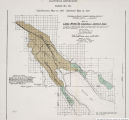
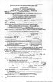
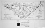
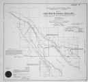
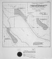
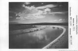
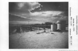
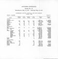
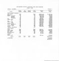
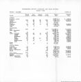
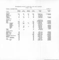
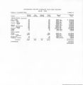
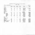
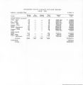
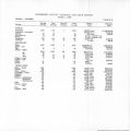
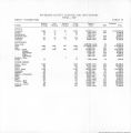
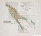
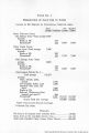
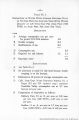
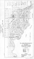
Show Table No. 1 Designation of Land Use in Acres Lands to Be Served in Coachella Service Area Gross Net Rounded Acreage Deductions Acreage Figures From Unlined Canal Dos Palmas Area-Total acreage 9,067 Exclude Roads at 5% 453 Farmsteads* M4 8,470 8,470 From Lined Canal Salton Area-Total acreage 7,980 Exclude Roads at 5% 399 Farmsteads* 126 7,455 7,460 Fish Springs Area-Total acreage 8,831 Exclude Roads at 5% 442 Farmsteads* lf° 8'249 8'250 Improvement District No. 1- Total acreage 135,275 Exclude Cities, schools, parks, airport 6,440 Non-irrigable Indian Land 2,280 Detention dike, basin and above 3,300 Roads at 5% 6,764 Railroad, Whitewater River channel and canal** 849 Farmsteads* 1,927 113,715 113,720 Grand Total Net Acreage 137,889 137,900 *Note: One acre per 60 acres (average). **Outside City Areas. Summary Net Area to be irrigated from Colorado River........................ 137,900 Gross Acres in the Coachella Service Area............................. 161,153 Total Area Coachella Valley County Water District................267,620 |
| Source |
Original book: [State of Arizona, complainant v. State of California, Palo Verde Irrigation District, Coachella Valley County Water District, Metropolitan Water District of Southern California, City of Los Angeles, California, City of San Diego, California, and County of San Diego, California, defendants, United States of America, State of Nevada, State of New Mexico, State of Utah, interveners] : California exhibits. |