| OCR Text |
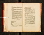
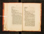
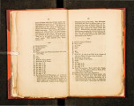
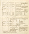
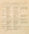
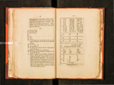
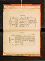
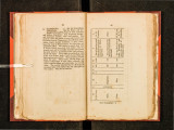
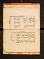
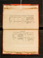
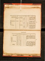
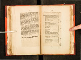
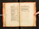
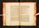
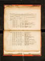
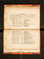
Show Continued, • • • miles. 638 pine Bluff, right side, . • • • 12 upper end d1tto, . . • • 5 cedars, • . 15 upper end ditto and mouth of Little river of the right, • • • . . 40 round prairie, right side (first fording place) • • • • . 20 lower end of Ion~ prairie, left side, . 25 upper end d1tto, . • • • . 40 next prairie same side, • • • . 12 upper end of the same, . . 20 3 mile oak and pine Bluff, • • . 30 Paean grove, •. . • • 9 upper end of the same, • • • • 6 prairie next above the paeans, • . 40 upper end of the same, • • . . 25 pine Bluff right side, • • " • • 45 white oak bluff, . • • • • 15 next prairie right side, • • • 45 upper end ditto, • • • . 30 bayau Galle, . right side, 6 mouth of Kiomitchie, or mine river, 25 - pine Bluff left side, . • • .. . 25 bay au Kick, or Bois d'arc creek, . 40 the .Vazzures, or Boggy river, right s1de, . . . . • • . • . 8 Blue river right side, . . • . . 50 Faux Oacheto or Missouri branch, . 25 Panis or Towiache towns, • . 70 Panis or ditto old towns, • 150 head branch of Red river, or dividing ridge, • • • • • .- 300 72 16! 231 668 -1,771 115 . Continued, • • • miles, 1,771 To whiCh ~nay be added for so much the dis-ta~ c~ bemg shortened by going through lake B1stmo, _than the course of the river, • • 60 Compu.ted length of Red river fr01n where it f~lls Into the Mississippi, to which add the dtstance from the mouth of Red river to the ocean, by either the Mississippi or the Cheffeli, .which was once probably the mouth of Red nver, • • • • • • 1,831 320 'fotallenth of Red river , miles. 2,151 |