| OCR Text |
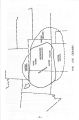
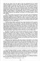
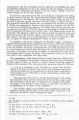
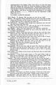
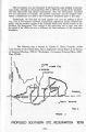
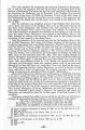
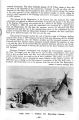
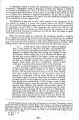
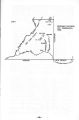
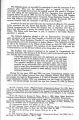
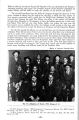
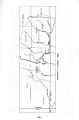
Show The Government was also frustrated. It still faced the same problem it had four years earlier, although in the period from 1876 to 1879 the concept of the Confederated Ute Reservation had altered tremendously. Now the Government visualized two Ute reservations in Colorado: the northern reservation and the southern reservation; a classification not used in the Government documents prior to this time. Traditionally, the Utes had not lived together and were not willing to do so now, even at Government insistence. Government negotiations finally accepted this reality, and the southern portion of the Colorado Reservation became known as the Southern Ute Reservation. This concept of the reservation was to carry over into the period of the 1880' s and was to influence the final settlement of the reservation boundaries. The following map is located in: Charles C. Royce, Compiler, Indian Land Cessions in the United States, Part 2, Eighteenth Annual Report of the Bureau of American Ethnology, 1896- 97, ( Washington: Government Printing Office, 1899), Plate CXVII. Ouray o o Lake City o Tellurfde o Silver ton Conejos Q Tierra Amarilla Taos o Abiquiu o PROPOSED SOUTHERN UTE . RESERVATION 1879 - 18- |