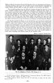
OCR Text |
Show Second. In consideration of the release and relinquishment aforesaid by said bands, the United States of America, by its said commissioners, agrees to set apart for the use and occupancy of said bands of Ute Indians a reservation on the headwaters of the Piedra, San Juan, Blanco, Navajo, and Chama Rivers, in the State of Colorado, the precise boundaries of which reservation to be hereafter defined by proclamation of the President. And the said United States of America further agrees to establish on said last- named territory, during the spring and summer of the year A. D. 1879, an Indian agency, and to erect proper and suitable buildings therefor. Third. And the said bands of Ute Indians also agree that they will not obstruct or in any wise interfere with travel upon any of the highways now open or hereafter to be opened by lawful authority in or upon said last- named reservation. Fourth. This agreement shall not be binding until confirmed by Congress and the President of the United States. 38 The new reservation was to contain about 728,320 acres of land which the commissioners believed to be well suited for the purposes for which it was designed. " It has a healthful climate, abounds in game and fish, and embraces a number of valleys of considerable extent and fertility." 39 Reassured of the welfare of the Utes by these comments, the President officially defined the new reservation as an area including a: ". tract of country in the State of Colorado, to wit: Commencing at the intersection of the 37th parallel of north latitude with the 107th degree of west longitude; thence east along said parallel to the ridge described in Hayden's Geographical and Geological Survey of said State as the ' National Divide' of the San Juan Mountains, thence following said divide in a general northerly and northwesterly direction to longitude 107 degrees and 23 minutes west; thence due south to latitude 37 degrees and 17 minutes north; thence due east to the 107th meridian of west longitude; thence south with said meridian to the place of beginning, be, and the same is hereby, withdrawn from sale and settlement and set apart as a reservation for the Muache, Capote, and Weeminuchee bands of Ute Indians. 4° In exchange for this new reservation the Utes gave up nearly 1,894,400 acres of land. The Commissioner of Indian Affairs felt that they should receive compensations Unfortunately, this provision had not been included in the agreement, a mistake on the part of the commission. Yet, the Southern Utes seemed to expect a compensation for their ceded land, a precedent set in prior negotiations and a matter of discussion in the negotiations that led to the signing of this agreement. In his report to Congress, the Commissioner recommended that they provide a survey of the ceded land and that it be placed for sale through the land office as part of the public domain. The revenue from this, minus the expenses of the sale and survey, would then be invested in four per cent bonds with the interest going for the " common benefit of all the Ute Indians who might settle upon the new reservation provided 38. Ibid., p. 4. 39. Ibid., p. 3. 40. Report of the Secretary of the Interior, 1882, op. cit., p. 319- 20. These lands were returned to the public domain by the same procedure on August 4, 1882. 41. Report of the Ute Commission to Congress, 1879, op. cit., p. 3. - 16- |