OCR Text |
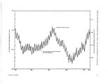
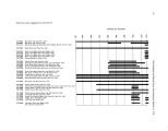
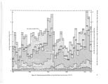
Show MODEL FOR EVALUATING THE EFFECTS OF DIKES ON THE WATER AND SALT BALANCE OF GREAT SALT LAKE, UTAH by K. M. Waddell1 and F. K. Fields1 ABSTRACT INTRODUCTION A model was developed for predicting the water and salt budget for various diking options in Great Salt Lake. The water budget was computed for 1- month intervals during a base period of 1931- 73. The storage change ( AS) during each month of the base period was computed from a budget of surface inflow ( Is), ground- water inflow ( Ig), precipitation on the lake surface ( Ip), and outflow from evaporation ( Oe), where AS = Is + Ip - Oe. By knowing the changes in storage, a prediction of altitude can be made from known altitude- volume relationships. The total annual inflow to Great Salt Lake ranged from about 1.5 to 5 million acre- feet ( 1,849.5 to 6,165.0 cubic hectometres). The Bear River contributes the largest percentage of the measured surface inflow. The total annual outflow from the lake ( evaporation) ranged from about 2.2 to 4.0 million acre- feet ( 2,712.6 to 4,932.0 cubic hectometres) during 1931- 73. The average annual evaporation was 2.98 million acre- feet ( 3,674.3 cubic hectometres) or 45 inches ( 1,143 millimetres) per year. The model provides for nine diking options. These include combinations of eight areas east of a line joining Antelope Island, Fremont Island, and the Promontory Mountains. Another option includes the part of Great Salt Lake that lies north of the Southern Pacific Transportation Co. causeway, which divides the main body of the lake into north and south parts. The model treats the salt balance of the diked areas from the standpoint of an inflow- outflow balance with complete mixing, and no allowances are made for any stratification or chemical changes due to interaction with the sediments or solution of entrapped brines or residual salts. Because the degree of inaccuracy created by these assumptions is not known, the concentrations predicted by the model should be regarded not as absolute but as relative indexes by which to compare various diking alternatives. 1 Hydrologist, U. S. Geological Survey. The concept of diking parts of Great Salt Lake, Utah, has long been considered as a means of controlling the salinity of the lake for more efficient salt production, of providing freshwater for recreation and other uses, and of controlling the annual fluctuation of lake levels in order to prevent flooding and inundation of evaporation ponds adjacent to the lake. The State of Utah has considered alternatives for the development of the resources of Great Salt Lake, and diking was one of the alternatives considered. The purpose of this study was to develop a digital- computer model which could be used to evaluate various diking proposals for their effect on the water and salt balance of Great Salt Lake. Evaluation of diking proposals for the lake required a knowledge of the parameters controlling the lake hydrology as well as the tool ( the model) to facilitate the computations necessary for relating these parameters to the lake dynamics. During 1971, the U. S. Geological Survey in cooperation with the Division of Water Resources, Utah Department of Natural Resources, began a 7- year study to monitor the principal parameters controlling the water balance, these parameters being surface inflow ( quantity and quality) and evaporation. A model study was originally planned as the last stage of the 7- year study, but the urgent needs of State planners indicated a requirement for earlier development of a working model. Thus in 1973, a second study was initiated to develop a model of the water and salt balance of the lake, with provisions for determining the effects of diking off various combinations of the three major inflowing streams. This model study, which was carried out in cooperation with the Utah Geological and Mineral Survey, was begun with the knowledge that the results would be preliminary until such time as sufficient data were available to provide a satisfactory data base. The model uses a simple water- and salt- budget approach for a closed lake. The monthly inflow and outflow ( evaporation) of water and of salt load to Great Salt Lake were estimated for a base period of 1931- 73. After calibration of the model with existing data, provisions were made in the model to evaluate the effects that diking of various combinations of bay |