| Title |
The City of the Saints and Across the Rocky Mountains to California |
| Subject |
Indians of North America; Church of Jesus Christ of Latter-day Saints; Latter Day Saints; Religion; Sioux Nation--History; Ute Indians--History; Indians; History; Missionaries; Indigenous peoples--North America |
| Keywords |
Travels; migration; Book; Native Americans |
| Publisher |
Digitized by J. Willard Marriott Library, University of Utah |
| Tribe |
Sioux; Ute |
| Language |
eng |
| Description |
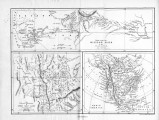
In "The City of Saints", author Richard Burton discusses his journey into Salt Lake City; and his experiences exploring the American West |
| Relation |
The City of the Saints.pdf |
| Type |
Text |
| Coverage |
Utah; Nevada |
| Format |
application/pdf |
| Rights |
Digital image copyright 2008, University of Utah. All rights reserved |
| ARK |
ark:/87278/s6cv7dks |
| Creator |
Burton, Richard Francis, Sir, 1821-1890 |
| Date |
1862 |
| Spatial Coverage |
Salt Lake City (Utah); Ruby Valley (Nev.); Utah; Nevada; Carson River Valley (Nev.) |
| Setname |
uaida_main |
| ID |
384326 |
| Reference URL |
https://collections.lib.utah.edu/ark:/87278/s6cv7dks |


