| Title |
Annual Report of the Commissioner of Indian Affairs - 1910 |
| Subject |
Indian reservations; Federal government; Indians of North America; Maps; Work; Land use; Allotment of land; Treaties; Agriculture; Timber; Health; Indians of North America--Social life and customs; Water rights; Natural resources; Employment (Economic theory); Education; Indians of North America--Education; Irrigation; Religion; Railroads; Fishing; Indigenous peoples--North America |
| Keywords |
Annual Report; Indian Agency; Reservations; Land Rights; Resources; Tribal Funds; Allotment; Trade; Native Americans |
| Publisher |
Digitized by J. Willard Marriott Library, University of Utah |
| Tribe |
Ute |
| Band |
Uintah |
| Language |
eng |
| Description |
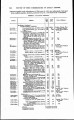
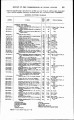
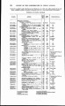
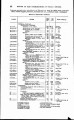
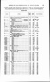
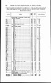
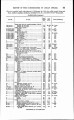
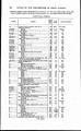
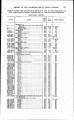
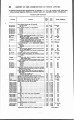
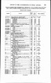
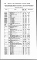
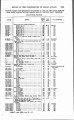
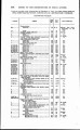
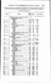
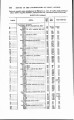
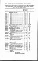
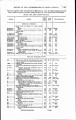
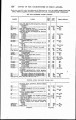
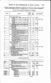
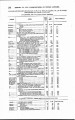
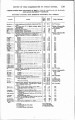
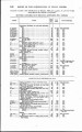
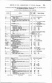
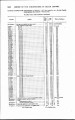
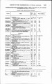
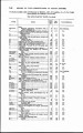
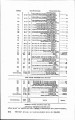
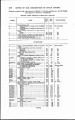
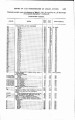
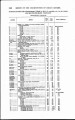
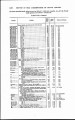
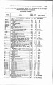
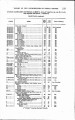
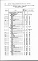
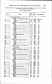
Excerpts concerning Utah from the Annual Report of the Commissioner of Indian Affairs - Courtesy of the University of Wisconsin Digital Collections. The Commissioner of Indian Affairs discusses employment in the department, efforts at preventing the sale and consumption of alcohol, policy and practices at Indian schools, the sale and use of Indian land, contracts awarded to serve the logistical needs of the agencies, etc. The Commissioner lists the cost and describes the progress of the Uintah Irrigation Project |
| Type |
Text |
| Coverage |
Uinta Basin (Utah and Colo.); Uintah and Ouray Indian Reservation (Utah); Utah; Washington (D.C.) |
| Format |
application/pdf |
| Rights |
Digital Image © 2011 America West Center. All Rights Reserved |
| ARK |
ark:/87278/s67m34n6 |
| Creator |
Commissioner of Indian Affairs; Valentine, Robert G. (Robert Grosvenor), 1872-1916 |
| Date |
1910 |
| Spatial Coverage |
Uinta Basin (Utah and Colo.); Uintah and Ouray Indian Reservation (Utah); Washington (D.C.); Utah |
| Setname |
uaida_main |
| ID |
378042 |
| Reference URL |
https://collections.lib.utah.edu/ark:/87278/s67m34n6 |