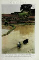
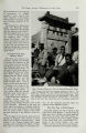
| OCR Text |
Show • • • • • * * • • * • • * • • • • • • • • * • • • • • • • • • • • * • • • • • * • • • * * * • • • • • • • * * • • • • • • • • • • • • • I Know Our Battle Fronts and Forces! | • • • Keep posted with Geographic Maps-including two enlargements- • * and Full-color Book of 2,476 Insignia of U. S. Armed Forces • » * • • • • • • • • • • • • • • • • • • • • • • • • • • • • • • • • • • • • • • • • • • • • • • • • • • • • • • • • • • • • • • • National Geographic Society Dept. C-R, Washington 6, D. C. Please send me the items indicated below: .1945 • All Maps except the two Enlarged Maps come on either paper or linen. Indexes are available for Maps marked with asterisk*. All items sent postage prepaid. China* The Philippines* U.S.S.R. (Russia)* Southeast Asia* Germany & Approaches* Japan & Adjacent Regions of Asia & Pacific Ocean* The World* E. & W. Hemispheres No. & So. Hemispheres* Pacific Ocean* (With 73 Island Insets.) Pacific Ocean and Bay of Bengal* Indian Ocean Atlantic Ocean United States* Europe and Near East* (Boundaries Sept. 1. 1939.) Europe & Mediterranean* (Boundaries Jan. I. 1938.) Europe and Near East (Shows partition Poland 1940.) Central Europe & Medit."1 British Isles Asia and Adjacent Areas' Canada* Africa* Mex., Cen. Am., & W. I.' South America* North America* Bible Lands* Classical Lands of Medit.* The Arctic Regions The Antarctic Regions How Many Copies Desired Paper Maps 50c each in U . S . & P O S B . Linen Maps $ 1 each in U.S. & Poss. Elsewhere $ 1 . 2 5 each Indexes 25c each in U.S. & Poss. Elsewhere 50c each X in Index column indicates Map Index is NOT available. Paper maps n folded for convenient filing. Linen maps come rolled. Postal regulatio usually prohibit mailing linen maps outside Western Hemisphere. A l s o CO p i e s O f M a p F i l e ( ^ $ 2 . 5 0 in U.S.&Poss. ;< wherc,$2.75. Also copies of Enlarged World Map* and copies of Enlarged Map of Northern and Southern Hemispheres* ® $ 2 each in U. S. & Poss.; elsewhere, $ 2 . 2 5 each. Sent rolled to U. S. & Poss. except Hawaiian Islands. Postal regulations necessitate folding these maps for mailing to Hawaiian Islands and places outside U. S. & Poss. Also copies of Armed Forces" ra$i "Insignia per copy In U I enclose remittance of % and Decorations S. & Poss.; elsewhero payable in U. of U. S. $ 1 . 2 5 . S. funds. Book of Insignia and Decorations of U. S. Armed Forces in Full Color THIS new book, prepared with the cooperation of Army and Navy authorities, is so complete that distribution was delayed last January as a precaution against the enemy obtaining data hitherto unpublished. An official release has now been granted. 2,476Jull-color reproductions and 159 monochrome photographs illustrate this revised and greatly enlarged presentation of the insignia, decorations, medals, service ribbons, and badges of the men and women in our fighting forces and other official organizations participating in the war effort. Comprehensive notes accompany the color reproductions of insignia of the U. S. Army and State Guard, Navy, Marine Corps, and Coast Guard; aircraft and torpedo boat insignia; and insignia of the Maritime Service, Public Health Service, Coast and Geodetic Survey, Army Transportation Corps Vessels, American Red Cross, Ship Production Awards, Army-Navy "E," American Field Service, Service Lapel Buttons, Civil Air Patrol, Fourra-gere, United Service Organizations, U. S. 0.-Camp Shows, Naval Air Transport Service, and Air Carrier Contract Personnel (ATC). A new chapter pictures the romance of aviation badges. 208 pages; 7 x 10 in. $1 in U. S. and Poss. Ten-color Maps for War or Peace To keep up with critical world-wide developments use the National Geographic Society's accurate wall maps. Particularly timely are the maps of "Germany," "Europe and Near East," "China," "Philippines," "Asia and Adjacent Areas," "Southeast Asia," and "Japan". . . . Map Indexes, available for maps marked with an asterisk * in adjoining order blank, describe areas covered and make easy the location of names on the related maps. Map File: This handy 7% x 10%-inch file, bound like a book, preserves maps for instant use. Ten pockets can hold 20 jolded paper maps of standard sizes or 10 jolded paper maps with Indexes. Enlarged World Map: A 67 x 43J^-inch enlargement of our standard World Map (41 x 26J3 inches). Printed in ten colors on heavy paper, it is incomparable for large wall display. The standard World Map Index may be used with this enlargement. Enlarged Map of No. and So. Hemispheres: This 67 x 351 6-inch map is enlarged from the standard 41 x 22-inch edition and the same Index applies to it. Ten colors; 4,262 place names; highly legible. • • • P R 1 C E S : Please refer to coupon for separate prices in "U. S. & Poss." and "Elsewhere." Remittances should be payable in U. S. Funds. All items sent postage prepaid. Obtainable only from the NATIONAL GEOGRAPHIC SOCIETY, Dept. C-R, Washington 6, D. C. |