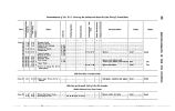
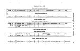
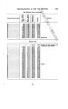
| OCR Text |
Show RECONNAISSANCE IN THE UTE COUNTRY. 9 Badito is merely a forage- station, with a store for the few Mexicans living hereabouts on the Huerfano. From Badito the ascent of the Sangre de Cristo Pass commences; this is a steady climb of 13J miles, the last third being very steep. Our barometer not having arrived at this time, no profile was obtained of this pass, but Gunnison's profile sufficiently demonstrates its useiessness as a railroad pass. For a wagon- road between Pueblo and Garland it is the most direct pass that can be obtained, and for that reason will probably not be abandoned for the lower route by the Huerfano Eiver, and Musca Pass northward, or the Yita Pass on the south. The best grade to be obtained, in the eastern ascent of this pass, is not less than 6 in 100 for certain distances of one-third of a mile, and it must be blocked by snow for a long season; otherwise it presents no obstacles to a good wagon- road; in fact, such a road already exists. The ascent on the left is the same, only the mountains are of short flanking spurs and the deep courses of small streams. On the right is the Huerfano River, cutting through the last hills of Greenhorn, and the Huerfano Park, a high, rolling valley, lying between the Greenhorn range and the Sangre de Oristo. Both of these ranges preseut high, well- marked crests, rising high above the out- lying hills, not at all the vague, jumble seen on the maps. The Sangre de Cristo spur puts off from the main range west of the Puncho Pass, near the head of the Arkansas, about latitude 3° 30' and longitude 106°, runs down north and east of the San Luis Valley to the^ point where we crossed it, and continues southward until it is known as the Raton Mountains. I have become familiar with the aspect of this spur from its separation from the main range to the Sangre de Cristo Pass. In all that distance it is a sharp range, rising abruptly from the San Luis Valley, more gradually from the hills skirting the Arkansas Valley, high above timber- line, of singular variety and boldness. The passes which we examined will be mentioned at the proper time. The west descent from the Sangre de Cristo Pass is down the Sangre de Cristo Creek, a small, bright stream. On this ( the west) side the grade is more uniformly distributed. The road is fair; the valley of the Sangre de Cristo is one or two huu-dred feet wide and fairly grassed, with little timber. . The hills on either hand rise from 200 to 1,001) feet above the stream, and present soft rolling outlines. About four miles from Fort Garland the Ute Creek is seen to debouch from between Graybuck Mountain and Sierra Blanca, and the road, leaving the Sangre de Cristo, crosses a barren plateau to that stream, which it follows to the fort. Fort Garland.- We arrived at Fort Garland on the evening of May 13, and were occupied until the 20th in a preliminary reduction of notes to that point, and in completing the outfit for the field. Little need be said of Fort Garland; it stands on the margin of the desolate San Luis Park, at the base of the Sangre de Cristo Mountains, a cluster of adobe buildings, comfortable and well arranged, but somewhat out of repair. The post is abundantly supplied with line water by an acequia from the Ute Creek, and with piiion wood from the hills. Abundant grazing is found in the hills near by, and numerous ranches on the Creek; the Sangre de Cristo and the Tunchera supply it with beef, vegetables, grain, and hay. At the camp, at the summit, we were joined by the photographer, Mr. Hine. At Fort Garland I received the barometers, two small aneroids by Cassella, and one mercurial cistern- barometer. All of these instruments were defective. The aueroids were too small. The cistern- barometer |