| Title |
Report of a reconnaissance in the Ute country made in the year 1873, by Lieut. E. H. Ruffner, corps of engineers |
| Subject |
Indians of North America; Federal government; Correspondence; Maps; Landscapes; Travel; Ute Indians--History; War; Ute Indians; Land use; Indigenous peoples--North America |
| Keywords |
Military; Correspondence; Land Marks; Native Americans |
| Publisher |
Digitized by J. Willard Marriott Library, University of Utah |
| File Name |
ReportofaReconnaissanceintheUteCountry.pdf |
| Tribe |
Ute |
| Language |
eng |
| Description |
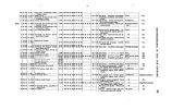
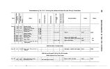
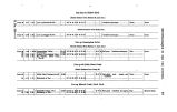
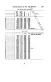
E.H. Ruffner describes the landscape of Ute territory west of Arkansas. Ruffner's report includes maps and tables outlining altitude, descriptions of timber, grass, and water conditions, etc |
| Type |
Image/StillImage |
| Format |
application/pdf |
| Rights |
Digital Image Copyright University of Utah |
| ARK |
ark:/87278/s6zk8c4f |
| Creator |
Ruffner, E. H. (Ernest Howard), 1845- |
| Date |
1873 |
| Spatial Coverage |
Utah |
| Setname |
uaida_main |
| ID |
354040 |
| Reference URL |
https://collections.lib.utah.edu/ark:/87278/s6zk8c4f |