| OCR Text |
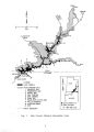
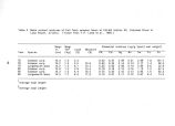
Show cooperative effort between the National Park Service, the Bureau of Reclamation, and the Utah Division of Wildlife Resources. This work should be repeated every six to eight years. Once funded, the research would be initiated via competitive contract to a qualified investigator; the specific study design would be determined by the selected investigator. However, a suggested study accounting for the parameters and lake stations requiring investigation might be as shown in Table 9. IV. C. Management IV. C. 1. Outstanding National Resource Waters. The Unique Waters nomination for the Lees Ferry segment of the Colorado River will be completed and forwarded to the State of Arizona. Consultation with state officials in Utah will be initiated to determine if criteria exist for similar designations in Utah. IV. C. 2. Water rights. The recreation area will continue to assert federal water rights through filings for consumptive uses and participation in water rights adjudications in Utah and Arizona. To maintain adequate background information for this activity, water requirements for specific uses will be quantified, including the instream flows needed for recreation and natural resources. This action will be implemented through coordination with the NPS Rocky Mountain Regional Office, the NPS Water Resources Division, and state agencies, all of which can assist in the development of background information and filing procedures. Water resources will be mapped, historical use documented, and statements of claim prepared as needed. Special projects may be proposed for funding to develop quantification of water needs for specific purposes. IV. C. 3. Floodplain identification and management. Backcountry flood hazards would be mapped and flood hazard information provided to visitors via brochures and/ or at information stations. Hazard zones with relatively high use rates will be posted seasonally. Should funding become available to increase backcountry ranger patrols, these patrols will be directed at identified hazard zones when floods are anticipated or active. For the Paria River and other large drainages extending beyond the NRA, communication procedures will be established ( or continued) with land managers upstream to provide early warning of flash floods descending on the recreation area. When high hazards are anticipated affecting known camping groups, the camps may be evacuated. Other measures may be proposed following completion of the recommended inventory of flood hazard zones. IV. C. 4. Shoreline water quality. The National Park Service proposes to phase in a program of management actions designed to eliminate an observed decline in water quality. Initial actions to be implemented could include the following: 73 |