| OCR Text |
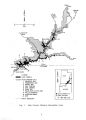
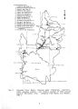
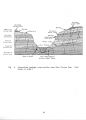
Show 111. C. Floodplain Identification and Management III. C. 1. Statement of the problem. Flash floods are a major concern in Glen Canyon National Recreation Area, particularly in summer and fall. Brief, intense thunderstorms produce high amounts of rain in a short period. Thin soil, sparse vegetation, and large areas of exposed bedrock do little to retain this rainfall, resulting in high runoff rates, flash floods in narrow drainages and canyons, and waterfalls off of canyon walls. The principal areas of concern are popular backcountry trails, mouths of canyons, locations for potential developed facilities, or any confined terrain where visitors congregate. For example, a trailhead at the Paria River is a departure point for the adjacent wilderness area, which has trails in high- hazard areas. Houseboaters on the lake frequently hike into the canyons from shoreline camps and may become exposed to flood hazards. Other backcountry users may encounter floods on roads and trails or at campsites within drainages. Flood hazards are of particular concern in Antelope Canyon, the Warm Creek/ Smoky Mountain area, in tributary canyons to the Escalante River, and in Dark Canyon, all locations where visitor use may be relatively high. The NRA has one developed facility, a maintenance shop, in the 100- year floodplain of the Paria River. This facility has been recommended for removal to a location outside of the floodplain. Legal and policy constraints apply to floodplain and wetland management in NPS areas. Specifically, compliance with Executive Order ( EO) 11988 ( Floodplain Management) and EO 11990 ( Protection of Wetlands) is required, along with the Water Resource Council's guidelines on floodplain and wetlands management. To implement these policies the National Park Service has issued servicewide guidelines for NPS units. These direct the Service to avoid placing facilities for visitors in high- flood- hazard zones and to provide warning measures in undeveloped areas frequented by park visitors that are within high- hazard zones. One difficulty in implementing the guidelines adequately is that little information exists about flood frequency in the Colorado Plateau region, principally because of short gauging records. Only the Paria River is gauged within the NRA; the other major rivers are gauged some distance upstream of the NRA boundary. There is no gauging record for lesser drainages. Ill .0.2. Management alternatives. Alternative A: No action Under this alternative, existing management would be continued using the NPS Floodplain Guidelines. For developed areas, floodplain 27 |