| OCR Text |
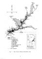
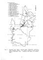
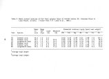
Show profiles was obtained in 1986, but the results will not be available until mid- 1987. Sediment erosion and deposition on river shorelines below the dam is also a significant resource management issue to neighboring Grand Canyon National Park, since the existence of the dam and fluctuating water releases have greatly changed erosion and deposition patterns of many beach areas in Grand Canyon. A multi- disciplinary, interagency team is currently investigating this problem and the possible effects of different water release schedules from the dam. II. F. Water Use All water consumptively used by the National Park Service operations at Wahweap, Bullfrog, Halls Crossing, Dangling Rope, and Lone Rock comes from deep wells. At Lees Ferry water is taken directly from the Colorado River, and at Hite it is taken directly from the lake. In 1979, consumption was estimated to be about 624 acre- feet per year from wells, 6 acre- feet per year from the lake, and 8 acre- feet per year from the Colorado River at Lees Ferry. The 14 acre- feet taken from the lake and from the Colorado River is about 5 percent of the 260 acre- feet reserved for the Glen Canyon Unit by Public Law 93- 423 ( NPS 1979) ( this allotment does not apply to ground- water withdrawals from wells). Abandoned wells at Wahweap, Hite, and Hans Flat are not being used because of water quality problems, although these wells are considered reserve water supply that could be used for certain applications. II. G. Monitoring Programs In 1965, the Bureau of Reclamation initiated a major ion chemistry and physical limnology monitoring program in Lake Powell. The purpose of this program was to create a comprehensive data base relating to the salinity and major ion changes brought about in the Colorado River Basin by the closing of the Glen Canyon Dam. Sampling locations, frequencies, and parameters measured have been modified slightly over the years ( Table 1). While this data collection program has focused primarily on salinity management questions, the long- term, consistent nature of this program has proved invaluable in providing baseline and trend information used in a number of studies. Due to budget constraints, sampling frequency was reduced in 1984 from monthly to quarterly. However, quarterly sampling should still be adequate to detect any major changes that could occur in response to changes in water management practices within the Colorado River Basin. Three long- term discharge and water quality stations, maintained cooperatively by the U. S. Geological Survey and the Bureau of Reclamation, monitor water quality of the major tributary inflow into Lake Powell ( Stations 4, 10, and 12 in Fig. 2). Data presently collected at these stations and their collection frequencies are given in Table 2. 16 |