| OCR Text |
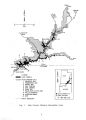
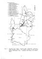
Show rainfall, though short stretches of streams below large springs can be perennial. Some intermittent streams flow throughout the year during wet years, but they do not exhibit other characteristics of perennial streams. On the mesas and benches of the NRA, the most common sources of surface water are waterpockets found in natural bedrock depressions. They occur where rain fills depressions weathered into exposed sandstone surfaces. Though some of these waterpockets are quite large, all are considered ephemeral. The U. S. Geological Survey has very few gauging stations on major rivers within the NRA ( Fig. 2). Rugged terrain, wilderness protection, and lake inundation have prevented the establishment of a more comprehensive stream- gauging network. As a result, little hydrologic data is available for these rivers near where they enter Lake Powell, although information gathered upstream on the San Juan, Green, and Colorado Rivers may be extrapolated for use at Lake Powell. The Paria River, which enters the Colorado River below Lake Powell, has been gauged since 1923 and monitored for water quality since 1947. Stream flows on the Escalante and Dirty Devil Rivers are less well known, especially because upstream flows on both rivers are affected by irrigation diversions. Some reaches of the Dirty Devil River are frequently dry during the summer because of irrigation withdrawals and II. D. 2. Surface- water quality. Utah Department of Natural Resources data for the Dirty Devil River show ranges in suspended sediment from 10 to 6,140 mg/ L during periods of stable flow ( Mundorff 1979). Extremely high concentrations occur during high flows, though only for a very short period. Another water quality indicator is TDS, which typically increase as water progresses downstream. At USGS gauging station # 09333500 on the Dirty Devil River, TDS ranges from 963 mg/ L to 3460 mg/ L ( Lindscov 1983). The Dirty Devil River is currently being studied by the Bureau of Reclamation for possible water quality improvement under the Colorado River Basin Salinity Control Act ( USDI 1983). Geochemical studies ( Reynolds and Johnson 1974) of Lake Powell indicate that its water is moderately saline ( 500 mg/ L TDS), and that its ionic composition is controlled by relative contributions from the Green, San Juan, and Colorado Rivers. The major ionic components present are ( in order of decreasing concentration) sulfate, calcium, sodium, alkalinity, magnesium, chloride, and potassium. Surface waters are oversaturated with respect to calcium carbonate; salt change calculations and comparisons of pre- and post- dam bicarbonate concentrations of river water at Lees Ferry suggest substantial precipitation of calcium carbonate in Lake Powell. H. D. 3. Flooding. Flash flooding commonly occurs in drainages of Glen Canyon NRA. Small drainage basins in mountainous areas or in steep 12 |