| OCR Text |
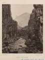
Show ATJTHOB'S PEEFACE. XXI Pavant the Carboniferous is represented as occupying exclusively the western side of the range. It is believed, however, that a few remnants of Triassic beds are to be found in that locality, but I am not able to designate accurately their positions. On the northwestern side of the Tushar also I am informed that there are some Archaean rocks, of which the exact location cannot be specified. A portion of the northwestern flank of the Tushar and the western side of the Pavant I have not visited, and the geological coloring is adopted in those portions as representing merely the dominant rocks. A considerable portion of the country lying south of the Wasatch Plateau is colored from data derived in part from my own observations and in part from those of Mr. Edwin E. Howell. There was some difficulty here in fixing in the field the demarkation between the Tertiary and Cretaceous, since the two series are not always well distinguished either by lithological characters or by fossils. But if the horizon chosen was properly selected the delineation is. believed to be accurate. South and southwest of the Markagunt Plateau a similar difficulty occurred in separating the Jura from the Trias, and the uncertainty here is somewhat greater. The boundary between those two formations, as delineated upon the map, may,~ upon more thorough investigation, receive some notable modifications, though I believe it represents very approximately the truth. In the valley of the Paria some slight modifications also may be necessary in locating with precision the same boundary line; and again upon the southeastern slopes of the Aquarius Plateau, around the net-work of canons tributary to the Escalante, the Trias and the Jura were utterly inaccessible, and the location of the separating horizon was inferred from the colors of the beds and the arrangement of the rocky ledges viewed from a distance. The colors and sculptural forms are most exceptionally characteristic in these two formations, and in this locality there is no possibility of mistaking them whenever they can be distinctly seen, whether from great or small distances The large area of the map devoted to the trachytes should be understood as meaning that in that area the trachytes are the dominant rocks. Commingled with them are the principal bodies of conglomerate and very extensive masses of andesite and dolerite. To define these intercalary |