Home
Browse
Ask Us
Chat
Harmful Language Statement
Log in
Institutional Repository
Advanced Search
Year
1905
1906
1907
1908
1909
1910
1911
1912
1913
1914
1915
1916
1917
1918
1919
1920
1921
1922
1923
1924
1925
1926
1927
1928
1929
1930
1931
1932
1933
1934
1935
1936
1937
1938
1939
1940
1941
1942
1943
1944
1945
1946
1947
1948
1949
1950
1951
1952
1953
1954
1955
1956
1957
1958
1959
1960
1961
1962
1963
1964
1965
1966
1967
1968
1969
1970
1971
1972
1973
1974
1975
1976
1977
1978
1979
1980
1981
1982
1983
1984
1985
1986
1987
1988
1989
1990
1991
1992
1993
1994
1995
1996
1997
1998
1999
2000
2001
2002
2003
2004
2005
2006
2007
2008
2009
2010
2011
2012
2013
2014
2015
2016
2017
2018
2019
2020
2021
2022
TO
1905
1906
1907
1908
1909
1910
1911
1912
1913
1914
1915
1916
1917
1918
1919
1920
1921
1922
1923
1924
1925
1926
1927
1928
1929
1930
1931
1932
1933
1934
1935
1936
1937
1938
1939
1940
1941
1942
1943
1944
1945
1946
1947
1948
1949
1950
1951
1952
1953
1954
1955
1956
1957
1958
1959
1960
1961
1962
1963
1964
1965
1966
1967
1968
1969
1970
1971
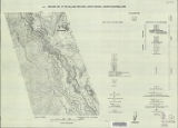
1972
1973
1974
1975
1976
1977
1978
1979
1980
1981
1982
1983
1984
1985
1986
1987
1988
1989
1990
1991
1992
1993
1994
1995
1996
1997
1998
1999
2000
2001
2002
2003
2004
2005
2006
2007
2008
2009
2010
2011
2012
2013
2014
2015
2016
2017
2018
2019
2020
2021
2022
Type
Text
439
Image
135
Dataset
1
Format
application/pdf
464
application/zip
35
application/vnd.google-earth.kmz
34
image/jpeg
7
Collection
Data Registry and Repository
1
Honors Theses Closed Archive
1
Honors Theses Open Access
3
Theses & Dissertations
434
UScholar Works
100
Undergraduate Works
1
More
Filters:
Department:
"Geology & Geophysics"
176
-
200
of
540
<
3
4
5
6
7
8
9
10
11
12
>
Gallery view
Number of results to display per page
10
25
50
100
200
Sort by Relevance
Sort by Title A-Z
Sort by Title Z-A
Sort by Date Ascending
Sort by Date Descending
Sort by Last Modified Ascending
Sort by Last Modified Descending
Title
Date
Type
Setname
176
Carbonate petrology of the Green River Formation (Eocene), Uinta Basin, Utah and Colorado
1972-08
Text
ir_etd
177
Geology of the San Arroyo gas Field Grand County, Utah
1972-08
Text
ir_etd
178
Structural geology of the Willard Peak area, North-Central Wasatch Mountains, Utah
1972-12
Text
ir_etd
179
Plate 1: Geologic map of the Willard Peak area, North-Central Wasatch Mountains, Utah (Google Earth map overlay KMZ file)
1972-12
Image
ir_etd
180
Structural geology of the Willard Peak Area, North-Central Wasatch Mountains, Utah: Georeferenced map files
1972-12
Image
ir_etd
181
Plate 2: Structure sections for geologic map of the Willard Peak area
1972-12
Image
ir_etd
182
Plate 3: Palinspastic middle and upper Cambrian columnar sections from western and northern Utah
1972-12
Image
ir_etd
183
Plate 4: Correlation of Precambrian rocks of the lower plate and upper plate of the Willard thrust with the Huntsville and Cottonwood areas
1972-12
Image
ir_etd
184
Plate 1: Geologic map of the Willard Peak area, North-Central Wasatch Mountains, Utah
1972-12
Image
ir_etd
185
Structural geology of the Willard Peak Area, North-Central Wasatch Mountains, Utah-Maps
1972-12
Image
ir_etd
186
Biostratigraphy of the Cambrian Glossopleura zone : west-central Utah.
1973
Text
ir_etd
187
Chesterian - Morrowan conodont biodtratigraphy from Northeastern Utah
1973
Text
ir_etd
188
Paleontology and Depositional Environments of the Cambrian Wheeler formation drum Mountains, West-Central Utah
1973
Text
ir_etd
189
Brecciation in the Ontario mine, east flank ore bodies, Park City district, Utah.
1973
Text
ir_etd
190
Geology of the Mercur Gold Camp, Utah
1973-06
Text
ir_etd
191
Sedimentology of the Dakota Formation (Cretaceous), Uinta Mountains, Northeastern Utah
1973-12
Text
ir_etd
192
Correlation of tuff layers in the Green River Formation, Utah, using biotite compositions
1974
Text
ir_etd
193
Biostratigraphy of the albertella and glossopleura zones (lower middle cambrian) of Northern Utah and Southern Idaho
1974
Text
ir_etd
194
Glaciation of the High Uintas Primitive Area, Utah with emphasis on the Northern slope
1974
Text
ir_etd
195
Plate 1 Generalized geologic map of the Laramide orogenic sediments of the Wasatch Hinterland (Google Earth map overlay KMZ file)
1974
Image
ir_etd
196
Clastic laramide sediments of the Wasatch Hinterland, Northeastern Utah: Georeferenced map files
1974
Image
ir_etd
197
Clastic laramide sediments of the Wasatch Hinterland, Northeastern Utah (Thesis and maps)
1974
Text; Image
ir_etd
198
Petrology of the moenkopi formation (Early Triassic), Uinta Mountain Area, Northeastern Utah
1974-06
Text
ir_etd
199
Fracture analysis, hydrodynamic properties and mineral abundance in altered igneous wall rocks of the Mayflower Mine, Park City District, Utah
1975
Text
ir_etd
200
Geology and geothermal potential of the Roosevelt Hot Springs area, Beaver County, Utah
1975
Text
ir_etd
176
-
200
of
540
<
3
4
5
6
7
8
9
10
11
12
>