TO
| Title | Date | Subject | Description | ||
|---|---|---|---|---|---|
| 76 |
 |
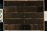
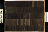
Skyline 16: SW SW sec. 10 11S 25E Uintah County, Utah. Box 56 Depth: 570.0 - 580.0 ft. | 2015-07 | core samples; Skyline 16; box 56; Green River Formation | Core sample photograph by the Utah Geological Survey at the University of Utah, and the Utah Core Research Center. Skyline 16: SW SW sec. 10 11S 25E Uintah County, Utah. Box 56 Depth: 570.0 - 580.0 ft. |
| 77 |
 |
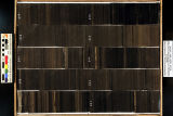
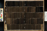
Skyline 16: SW SW sec. 10 11S 25E Uintah County, Utah. Box 58 Depth: 590.0 - 600.0 ft. | 2015-07 | core samples; Skyline 16; box 58; Green River Formation | Core sample photograph by the Utah Geological Survey at the University of Utah, and the Utah Core Research Center. Skyline 16: SW SW sec. 10 11S 25E Uintah County, Utah. Box 58 Depth: 590.0 - 600.0 ft. |
| 78 |
 |
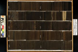
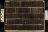
Skyline 16: SW SW sec. 10 11S 25E Uintah County, Utah. Box 44 Depth: 450.0 - 460.0 ft. | 2015-07 | core samples; Skyline 16; box 44; Green River Formation | Core sample photograph by the Utah Geological Survey at the University of Utah, and the Utah Core Research Center. Skyline 16: SW SW sec. 10 11S 25E Uintah County, Utah. Box 44 Depth: 450.0 - 460.0 ft. |
| 79 |
 |
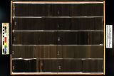
Skyline 16: SW SW sec. 10 11S 25E Uintah County, Utah. Box 31 Depth: 320.0 - 330.0 ft. | 2015-07 | core samples; Skyline 16; box 31; Green River Formation | Core sample photograph by the Utah Geological Survey at the University of Utah, and the Utah Core Research Center. Skyline 16: SW SW sec. 10 11S 25E Uintah County, Utah. Box 31 Depth: 320.0 - 330.0 ft. |
| 80 |
 |
Skyline 16: SW SW sec. 10 11S 25E Uintah County, Utah. Box 32 Depth: 330.0 - 340.0 ft. | 2015-07 | core samples; Skyline 16; box 32; Green River Formation | Core sample photograph by the Utah Geological Survey at the University of Utah, and the Utah Core Research Center. Skyline 16: SW SW sec. 10 11S 25E Uintah County, Utah. Box 32 Depth: 330.0 - 340.0 ft. |
| 81 |
 |
Skyline 16: SW SW sec. 10 11S 25E Uintah County, Utah. Box 29 Depth: 300.0 - 310.0 ft. | 2015-07 | core samples; Skyline 16; box 29; Green River Formation | Core sample photograph by the Utah Geological Survey at the University of Utah, and the Utah Core Research Center. Skyline 16: SW SW sec. 10 11S 25E Uintah County, Utah. Box 29 Depth: 300.0 - 310.0 ft. |
| 82 |
 |
Skyline 16: SW SW sec. 10 11S 25E Uintah County, Utah. Box 24 Depth: 250.0 - 260.0 ft. | 2015-07 | core samples; Skyline 16; box 24; Green River Formation | Core sample photograph by the Utah Geological Survey at the University of Utah, and the Utah Core Research Center. Skyline 16: SW SW sec. 10 11S 25E Uintah County, Utah. Box 24 Depth: 250.0 - 260.0 ft. |
| 83 |
 |
Skyline 16: SW SW sec. 10 11S 25E Uintah County, Utah. Box 33 Depth: 340.0 - 350.0 ft. | 2015-07 | core samples; Skyline 16; box 33; Green River Formation | Core sample photograph by the Utah Geological Survey at the University of Utah, and the Utah Core Research Center. Skyline 16: SW SW sec. 10 11S 25E Uintah County, Utah. Box 33 Depth: 340.0 - 350.0 ft. |
| 84 |
 |
Skyline 16: SW SW sec. 10 11S 25E Uintah County, Utah. Box 23 Depth: 240.0 - 250.0 ft. | 2015-07 | core samples; Skyline 16; box 23; Green River Formation | Core sample photograph by the Utah Geological Survey at the University of Utah, and the Utah Core Research Center. Skyline 16: SW SW sec. 10 11S 25E Uintah County, Utah. Box 23 Depth: 240.0 - 250.0 ft. |
| 85 |
 |
Skyline 16: SW SW sec. 10 11S 25E Uintah County, Utah. Box 34 Depth: 350.0 - 360.0 ft. | 2015-07 | core samples; Skyline 16; box 34; Green River Formation | Core sample photograph by the Utah Geological Survey at the University of Utah, and the Utah Core Research Center. Skyline 16: SW SW sec. 10 11S 25E Uintah County, Utah. Box 34 Depth: 350.0 - 360.0 ft. |
| 86 |
 |
Skyline 16: SW SW sec. 10 11S 25E Uintah County, Utah. Box 26 Depth: 270.0 - 280.0 ft. | 2015-07 | core samples; Skyline 16; box 26; Green River Formation | Core sample photograph by the Utah Geological Survey at the University of Utah, and the Utah Core Research Center. Skyline 16: SW SW sec. 10 11S 25E Uintah County, Utah. Box 26 Depth: 270.0 - 280.0 ft. |
| 87 |
 |
Skyline 16: SW SW sec. 10 11S 25E Uintah County, Utah. Box 30 Depth: 310.0 - 320.0 ft. | 2015-07 | core samples; Skyline 16; box 30; Green River Formation | Core sample photograph by the Utah Geological Survey at the University of Utah, and the Utah Core Research Center. Skyline 16: SW SW sec. 10 11S 25E Uintah County, Utah. Box 30 Depth: 310.0 - 320.0 ft. |
| 88 |
 |
Skyline 16: SW SW sec. 10 11S 25E Uintah County, Utah. Box 21 Depth: 220.0 - 230.0 ft. | 2015-07 | core samples; Skyline 16; box 21; Green River Formation | Core sample photograph by the Utah Geological Survey at the University of Utah and the Utah Core Research Center. Skyline 16: SW SW sec. 10 11S 25E Uintah County, Utah. Box 21 Depth: 220.0 - 230.0 ft. |
| 89 |
 |
Skyline 16: SW SW sec. 10 11S 25E Uintah County, Utah. Box 25 Depth: 260.0 - 270.0 ft. | 2015-07 | core samples; Skyline 16; box 25; Green River Formation | Core sample photograph by the Utah Geological Survey and the University of Utah, and the Utah Core Research Center. Skyline 16: SW SW sec. 10 11S 25E Uintah County, Utah. Box 25 Depth: 260.0 - 270.0 ft. |
| 90 |
 |
Skyline 16: SW SW sec. 10 11S 25E Uintah County, Utah. Box 28 Depth: 290.0 - 300.0 ft. | 2015-07 | core samples; Skyline 16; box 28; Green River Formation | Core sample photograph by the Utah Geological Survey at the University of Utah, and the Utah Core Research Center. Skyline 16: SW SW sec. 10 11S 25E Uintah County, Utah. Box 28 Depth: 290.0 - 300.0 ft. |
| 91 |
 |
Skyline 16: SW SW sec. 10 11S 25E Uintah County, Utah. Box 27 Depth: 280.0 - 290.0 ft. | 2015-07 | core samples; Skyline 16; box 27; Green River Formation | Core sample photograph by the Utah Geological Survey at the University of Utah, and the Utah Core Research Center. Skyline 16: SW SW sec. 10 11S 25E Uintah County, Utah. Box 27 Depth: 280.0 - 290.0 ft. |
| 92 |
 |
Skyline 16: SW SW sec. 10 11S 25E Uintah County, Utah. Box 22 Depth: 230.0 - 240.0 ft. | 2015-07 | core samples; Skyline 16; box 22; Green River Formation | Core sample photograph by the Utah Geological Survey at the University of Utah, and the Utah Core Research Center. Skyline 16: SW SW sec. 10 11S 25E Uintah County, Utah. Box 22 Depth: 230.0 - 240.0 ft. |
| 93 |
 |
Clean and Secure Energy from Domestic Oil Shale and Oil Sands Resources: Quarterly progress report - January 2015 to March 2015 | 2015 | quarterly report; domestic oil shale resources; domestic oil sands resources; unconventional fuels; oil shale; oil sands | The Clean and Secure Energy from Domestic Oil Shale and Oil Sands Resources program, part of the research agenda of the Institute for Clean and Secure Energy (ICSE) at the University of Utah, is focused on engineering, scientific, and legal research surrounding the development of these resources in ... |
| 94 |
 |
Pore scale analysis of oil shale pyrolysis by X-ray CT and LB simulation | 2010-09-09 | pore scale analysis; oil shale pyrolysis; X-ray CT; LB simulation; oil shale; shale oil procuction; pore structure | There are important questions concerning the quality and volume of pore space that is created when oil shale is pyrolyzed for the purpose of producing shale oil. In this paper, we pyrolyzed 1.9 cm diameter cores at different temperatures and heating rates. Detailed 3D imaging of the core before and ... |
| 95 |
 |
Underground coal thermal treatment research at the University of Utah | 2011-03-23 | underground coal; thermal treatment research; University of Utah; underground coal pyrolysis; SNG yeilds; UCTT | 6th Annual International Conference & Workshop on Underground Coal Gasification, 23rd - 24th March 2011 |
| 96 |
 |
Accelerating deployment of retrofitable CO2 capture technologies through predictivity: (Simulation, verification, validation / uncertainty quantification) - 2010 Annual report (for year 1 of 3) to DOE NNSA from The University of Utah | 2011 | CO2; CO2 capture technologies; predictivity; fossil-fuel utilization | There is an ever increasing national awareness that an effective, sustainable energy future must include fossil-fuel utilization that deploys cost-efficient technologies (both new and retrofit) that significantly improve energy efficiencies and reduce CO2 emissions over existing electric power and t... |
| 97 |
 |
Integrated sedimentary and geochemical investigation of core form the upper Green River Formation lacustrine deposits, Uinta Basin, Utah | 2010-04-12 | upper Green River formation; lacustrine deposits; geochemical investigation; lithofacies; facies | Description of the upper Green River Formation has been largely based on outcrop exposures, but this core-based investigation provides newly detailed subsurface data that can be used to examine basin-wide lithologic and geochemical variability of he Parachute Creek Member of the upper Green River Fo... |
| 98 |
 |
SO3 formation during oxy-coal combustion - Presentation | 2010-06-10 | SO3; oxy-coal combustion; controlled condensation method; sulfur combustion; pilot-scale combustor | In oxy-coal combustion, an oxygen and carbon dioxide mixture, rather than air, is used to burn the coal. Many studies to date have focused on the formation of NOx under oxy-coal combustion conditions; however, the formation of sulfur species, particularly sulfur trioxide, is currently not a wellunde... |
| 99 |
 |
SO3 formation during oxy-coal combustion | 2010-06-10 | oxy-coal combustion; SO3 formation; formation of sulfur compounds; sulfur | In oxy-coal combustion, an oxygen and carbon dioxide mixture, rather than air, is used to burn the coal. Many studies to date have focused on the formation of NOx under oxy-coal combustion conditions; however, the formation of sulfur species, particularly sulfur trioxide, is currently not a well und... |
| 100 |
 |
Structural characterization of Green River oil shale core segments and the kerogen isolated from these segments | 2011-09-18 | structural characterization; Green River oil shale; oil shale core segments; kerogen; chemical structure of oil shale and kerogen; QEMScan | The goal is to obtain information about chemical structure of oil shale and its kerogen. This includes chemical characterization of the shale, the isolated kerogen, and the products of pyrolysis of both the shale and kerogen, and provides data for validation of modeling component of the project (lat... |