Home
Browse
Ask Us
Chat
Harmful Language Statement
Log in
Institutional Repository
Advanced Search
Year
1905
1906
1907
1908
1909
1910
1911
1912
1913
1914
1915
1916
1917
1918
1919
1920
1921
1922
1923
1924
1925
1926
1927
1928
1929
1930
1931
1932
1933
1934
1935
1936
1937
1938
1939
1940
1941
1942
1943
1944
1945
1946
1947
1948
1949
1950
1951
1952
1953
1954
1955
1956
1957
1958
1959
1960
1961
1962
1963
1964
1965
1966
1967
1968
1969
1970
1971
1972
1973
1974
1975
1976
1977
1978
1979
1980
1981
1982
1983
1984
1985
1986
1987
1988
1989
1990
1991
1992
1993
1994
1995
1996
1997
1998
1999
2000
2001
2002
2003
2004
2005
2006
2007
2008
2009
2010
2011
2012
2013
2014
2015
2016
2017
2018
2019
2020
2021
2022
TO
1905
1906
1907
1908
1909
1910
1911
1912
1913
1914
1915
1916
1917
1918
1919
1920
1921
1922
1923
1924
1925
1926
1927
1928
1929
1930
1931
1932
1933
1934
1935
1936
1937
1938
1939
1940
1941
1942
1943
1944
1945
1946
1947
1948
1949
1950
1951
1952
1953
1954
1955
1956
1957
1958
1959
1960
1961
1962
1963
1964
1965
1966
1967
1968
1969
1970
1971
1972
1973
1974
1975
1976
1977
1978
1979
1980
1981
1982
1983
1984
1985
1986
1987
1988
1989
1990
1991
1992
1993
1994
1995
1996
1997
1998
1999
2000
2001
2002
2003
2004
2005
2006
2007
2008
2009
2010
2011
2012
2013
2014
2015
2016
2017
2018
2019
2020
2021
2022
Type
Text
439
Image
135
Dataset
1
Format
application/pdf
464
application/zip
35
application/vnd.google-earth.kmz
34
image/jpeg
7
Collection
Data Registry and Repository
1
Honors Theses Closed Archive
1
Honors Theses Open Access
3
Theses & Dissertations
434
UScholar Works
100
Undergraduate Works
1
More
Filters:
Department:
"Geology & Geophysics"
76
-
100
of
540
<
1
2
3
4
5
6
7
8
9
10
>
Gallery view
Number of results to display per page
10
25
50
100
200
Sort by Relevance
Sort by Title A-Z
Sort by Title Z-A
Sort by Date Ascending
Sort by Date Descending
Sort by Last Modified Ascending
Sort by Last Modified Descending
Title
Date
Type
Setname
76
Geology of the Promontory Range, Box Elder County, Utah
1960
Text
ir_etd
77
Geology of the Promontory Range, Box Elder County, Utah
1960-06
Text
ir_etd
78
Geology of the upper Ogden Canyon, Weber County, Utah: Georeferenced map files
1960-06
Image
ir_etd
79
Geology of the upper Ogden Canyon, Weber County, Utah
1960-06
Text; Image
ir_etd
80
Map 1 Geology of the upper Ogden Canyon, Weber County, Utah (Google Earth map overlay KMZ file)
1960-06
Image
ir_etd
81
Hydrology of middle Canyon, Oquirrh Mountains, Tooele County, Utah
1960-08
Text
ir_etd
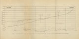
82
Figure 4: Longitudinal profile of Middle Canyon showing locations of the profiles across the canyon, the nickpoint, and the hypothetical profile before rejuvenation
1960-08
Image
ir_etd
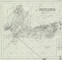
83
Geology and ore deposits of the Lucin Mining District, Box Elder County, Utah and Elko County, Nevada: Georeferenced map files
1960-08
Image
ir_etd
84
The geology and erosional development Northern Bryce Canyon National Park
1961
Text
ir_etd
85
Stratigraphic analysis of the Mesaverde Group, Uinta Basin, Utah: Georeferenced map files
1961-05
Image
ir_etd
86
Stratigraphic analysis of the Mesaverde Group, Uinta Basin, Utah
1961-05
Text; Image
ir_etd
87
Stratigraphic analysis of the Mesaverde Group, Uinta Basin, Utah (Google Earth map overlay KMZ file)
1961-05
Image
ir_etd
88
Geology of a part of Northwestern Uinta County, Wyoming
1961-06
Text
ir_etd
89
Subsurface geology of the Mesozoic formations overlying the Uncompahgre Uplift in Grand County, Utah: Georeferenced map files
1961-06
Image
ir_etd
90
Subsurface geology of the Mesozoic formations overlying the Uncompahgre Uplift in Grand County, Utah
1961-06
Text; Image
ir_etd
91
Geology of the Central and Southern Silver Island Mountains Tooele County, Utah and Elko County, Nevada
1961-06
Text
ir_etd
92
Geology and erosional development of Northern Bryce Canyon National Park
1961-06
Text
ir_etd
93
Geology of the Central and Southern Silver Island Mountains Tooele County, Utah and Elko County, Nevada: Georeferenced map files
1961-06
Image
ir_etd
94
Plate 1: Geologic map of Northern Bryce Canyon National Park
1961-06
Image
ir_etd
95
Plate 1B: Geologic map of the Central and Southern Silver Island Mountains, Box Elder and Tooele Counties, Utah, and Elko County, Nevada (Google Earth map overlay KMZ file)
1961-06
Image
ir_etd
96
Subsurface geology of the Mesozoic formations overlying the Uncompahgre Uplift in Grand County, Utah (Google Earth map overlay KMZ file)
1961-06
Image
ir_etd
97
Plate 1C: Geologic cross sections of the Central and Southern Silver Island Mountains, Box Elder and Tooele Counties, Utah and Elko County, Nevada
1961-06
Image
ir_etd
98
Plate 1B: Geologic map of the Central and Southern Silver Island Mountains, Box Elder and Tooele Counties, Utah, and Elko County, Nevada
1961-06
Image
ir_etd
99
Geology of the Cove Creek area Millard County and Beaver County, Utah
1961-06
Text; Image
ir_etd
100
Geology of the Central and Southern silver Island Mountains Tooele County, Utah and Elko County, Nevada-Maps
1961-06
Image
ir_etd
76
-
100
of
540
<
1
2
3
4
5
6
7
8
9
10
>