TO
Filters: Collection: "ir_eua"
| Title | Date | Subject | Description | ||
|---|---|---|---|---|---|
| 326 |
 |
Energy resources map of Utah (no. 44) | 1974 | energy resources | Edition of 1959 of the U.S. Geological Survey, modified 1974 by the Utah Geological and Mineral Survey |
| 327 |
 |
Informational core drilling in Utah's oil-impregnated sandstone deposits, southeast Uinta Basin Uinta Couny, Utah | 1974-02 | core drilling; Utah's oil-impregnated sandstone deposits; coring; Rim Rock; P. R. Spring; Hill Creek | This program was undertaken under Grant No. GO122094 from the U.S. Department of the Interior, Bureau of Mines to the Utah Geological and Mineral Survey, dated June 15, 1972. Amount of the grant was $77, 200. Principal investigator was Howard R. Ritzma, Petroleum Geologist, Utah Geological and Miner... |
| 328 |
 |
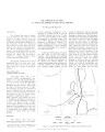
Towanta Lineament, Northern Utah | 1974-06 | Towanta Lineament; geologic mapping; mineralization; relation to ground water | A lineament, herein called the Towanta Lineament, was first noticed on a composite raised relief map of Utah and has been traced on aerial and satellite photograph)' and topographic maps for about 220 miles (350 kms.). Parrs of the eastern half have been examined in the field. The lineament extends ... |
| 329 |
 |
Oil-impregnated rock deposits of Utah | 1974-07 | ||
| 330 |
 |
A proposed oil extraction and strip-mining project | 1974-08-23 | The Utah Division of Oil & Gas Conservation, 1588 West North Temple, Salt Lake City, Utah, has received an application from the Sohio Petroleum Company to conduct mining operations for the removal and processing of the commercially minable deposits of bituminous sands on the following described land... | |
| 331 |
 |
Report of investigation: Oil-impregnated rocks and other evidences of petroleum | 1974-09 | petroleum; oil-impregnated sandstone; oil seep | General geology: The surface geology is entirely Uinta Formation. Most rocks are thinly laminated, fine-grained lacustrine shales and cherts. Only a few sandstone units are present, which are predominantly fine-grained, well-cemented, and lacking in porosity and permeability. Regional dip is gently ... |
| 332 |
 |
Report on the development and implementation of the Utah process land use and tax base model | 1974-09 | The preparation of this report was financially aided through a Federal Grant from the Department of Housing and Urban Development, under the Comprehensive Planning Assistance Pregram authorized by Section 701 of the Housing Act of 1954, as amended. | |
| 333 |
 |
In situ instrumentation: Final report of a joint EE/ME group study | 1974-10-25 | in situ instrumentation; EE/ME; fossil fuel; geothermal resources; in situ processing; oil shale; coal deposits; geothermal resources; measurements for energy process; instrumentation; instrumentation development; development costs | Greater utilization of our fossil fuel and geothermal resources is vital to our future national economic well-being. However, the economic utilization of oil shale, some coal deposits and geothermal resources may depend on in situ processing. In turn, the optimal development of in situ coal gasifica... |
| 334 |
 |
Properties of Utah tar sands--Asphalt Wash area, P. R. Spring deposit | 1975 | Asphalt Wash Area; P. R. Spring tar sand deposit; tar sand zones; oil; tar sand evaluation | This Bureau of Mines report presents the analysis of three cores from the Asphalt Wash area of the P.R. Spring tar sand deposit of northeastern Utah. Two tar sand zones are indicated in the Asphalt Wash Area. Total net thickness of the tar sand ranges from 23 to 39 ft, with occurrences between 56 an... |
| 335 |
 |
Interpretation of fischer assay data for the evaluation of analcime-bearing oil shale in the Green River Formation, Colorado and Utah | 1975 | fischer assay data; analcime-bearing oil shale; Green River Formation; potential oil yeild of sediments | Using Fischer assay data, an empirical method has been devised for distinguishing analcime-rich oil shale from oil shale which is essentially free of analcime in the Parachute Creek Member, Green River Formation, Colorado and Utah. This method permits evaluation of Fischer assay data in order to com... |
| 336 |
 |
Heavy oil prospect NW Asphalt Ridge Uintah County, Utah | 1975 | heavy oil; heavy oil prospect; NW Asphalt Ridge; thermal recovery project | A 150 million barrel accumulation of heavy oil (14° API) underlies an 1120 acre Tom Brown, Inc. tract located six miles west of Vernal, Utah. A recently completed six-well corehole project provided the data to delineate this major accumulation. The following combination of geological and engineerin... |
| 337 |
 |
Lithofacies and related hydrocarbon accumulations in Tertiary strata of the western and central Uinta Basin, Utah | 1975 | lithofacies; hydrocarbon accumulations; Tertiary strata; Uinta Basin; stratigraphy | Strata of Tertiary age in the Uinta Basin were deposited in an internally drained depression. They can be divided into (1) a central core of organic-rich open lacustrine claystone and mud-supported carbonate surrounded by (2) marginal lacustrine sandstone, claystone and mud- and grain-supported carb... |
| 338 |
 |
Preliminary mineral resource study of the Uintah and Ouray reservation, Utah | 1975 | mineral resources; production of oil and gas; oil shale industry development; coal resources | Development of known mineral resources on the Uintah and Ouray Indian Reservation probably will be confined to expanded production of oil and gas by conventional methods and to extraction of modest amounts of sand and gravel. Oil shale may have some development potential provided exploration can pro... |
| 339 |
 |
Projections for school population and teacher demand in the State of Utah for the period 1970-2000 | 1975 | This study deals with probable future trends in student enrollment, accoroing to age, sex, grades, and school levels, for different geographic areas, and teacher demand for the elementary and secondary levels of school in Utah from 1970 to the year 2000. For the secondary level schools, information ... | |
| 340 |
 |
The Chinese wax mine: A unique oil-impregnated rock deposit | 1975 | Chinese wax mine; oil-impregnated rock deposit; oil; mineral wax; viscous oil | The Chinese Wax mine in Daniels Canyon, Wasatch County, Utah, is a small deposit of black, viscous, waxy oil emplaced in fractured, brecciated Oquirrh Formation (Pennsylvanian-Permian) on the Strawberry Valley (or Charleston) thrust sheet where the thrust has overriden the west margin of the Uinta B... |
| 341 |
 |
State planning in Utah | 1975 | In the fall of 1967, Ken Olson was considering the approach he would take in directing Utah's state planning program. The Governor had just appointed him State Planning Coordinator, to assume responsibility for the four year old program. Ken had earlier won the respect of the Governor and the previo... | |
| 342 |
 |
1975-76 General Catalog | 1975 | University of Utah catalogue; (Catalog) | General Catalog Bulletin of the University of Utah 125th Year |
| 343 |
 |
The Navajo economic-demographic model a method for forecasting and evaluating alternative Navajo economic futures Volume 1: A technial description of the model | 1975 | In April 1975, the Four Corners Regional Commission extended a grant to the Navajo Tribe, through its Office of Program Development, to develop an increased planning and decision-making capability by producing the capacity of projecting the consequences of alternative Navajo economic futures. With t... | |
| 344 |
 |
Properties of Utah tar sands--South Seep Ridge area, P. R. Spring deposit | 1975 | Seep Ridge area; P. R. Spring tar sand deposit; tar sand zones | The Bureau of Mines analyzed three cores from the south Seep Ridge area of the P. R. Spring tar sand deposit of northeastern Utah. Four tar sand zones are indicated in the area. The zones range in average thickness from 13 to 24 ft. The total net thickness of the tar sand in the three coreholes rang... |
| 345 |
 |
Intergovernmental planning coordination: The Utah Experience | 1975-01 | This report describes the approach and process used in Utah to provide for intergovernmental planning coordination. Since planning is essential to provide decision makers with information on possible courses of future action, it is also essential that decisions affecting future investments in govern... | |
| 346 |
 |
Energy resources map of Utah (no. 36) | 1975-05-01 | energy resources | |
| 347 |
 |
Lithologic logs and correlation of coreholes P. R. Spring and Hill Creek oil-impregnated standstone deposits Uintah County, Utah | 1975-08 | lithologic logs; correlation of coreholes; P. R. Spring; Hill Creek; oil-impregnated sandstone deposits; Utah | This report of investigation presents the lithologic logs and correlation of 16 coreholes drilled in 1973 in the P. R. Spring and Hill Creek oil-impregnated sandstone deposits, southeast Uintah County, Utah. The program was conducted under Grant No. GO 122094 from the U. S. Department of the Interio... |
| 348 |
 |
The Utah process alternative futures 1975-1990, volume 1: assumptions and projections | 1975-09 | Volumes I and II of The Utah Process Alternative Futures, 1975-1990, contain the set of Alternative Future projections of economic and demographic conditions produced by the Utah State Planning Coordinator's Office for the State of Utah and its Multi-County Planning Districts (MCD) in response to th... | |
| 349 |
 |
The San Rafael oil fields; where the oil runs out of the rocks | 1975-09 | San Rafael oil fields; oil; oil field | The following article has been prepared and written with the object of furnishing accurate and dependable information of what is, perhaps, as little known a region as exists in this Twentieth Century. It is a country of wonderful possibilities and the writer after years of careful observation and ex... |
| 350 |
 |
Recovery of bitumen from oil-impregnated sandstone deposits of Utah | 1975-11 | potential oil; bitumen; oil-impregnated sandstone (tar sand) deposits; tar sands; bitumen recovery | Utah contains at least 26 billion barrels of potential oil as bitumen in oil-impregnated sandstone (tar sand) deposits. As shown in this paper, these tar sands are significantly different in physical and chemical properties from commercially developed Canadian tar sands. These differences prevent di... |