Home
Browse
Ask Us
Chat
Harmful Language Statement
Log in
Institutional Repository
Advanced Search
Year
1905
1906
1907
1908
1909
1910
1911
1912
1913
1914
1915
1916
1917
1918
1919
1920
1921
1922
1923
1924
1925
1926
1927
1928
1929
1930
1931
1932
1933
1934
1935
1936
1937
1938
1939
1940
1941
1942
1943
1944
1945
1946
1947
1948
1949
1950
1951
1952
1953
1954
1955
1956
1957
1958
1959
1960
1961
1962
1963
1964
1965
1966
1967
1968
1969
1970
1971
1972
1973
1974
1975
1976
1977
1978
1979
1980
1981
1982
1983
1984
1985
1986
1987
1988
1989
1990
1991
1992
1993
1994
1995
1996
1997
1998
1999
2000
2001
2002
2003
2004
2005
2006
2007
2008
2009
2010
2011
2012
2013
2014
2015
2016
2017
2018
2019
2020
2021
2022
TO
1905
1906
1907
1908
1909
1910
1911
1912
1913
1914
1915
1916
1917
1918
1919
1920
1921
1922
1923
1924
1925
1926
1927
1928
1929
1930
1931
1932
1933
1934
1935
1936
1937
1938
1939
1940
1941
1942
1943
1944
1945
1946
1947
1948
1949
1950
1951
1952
1953
1954
1955
1956
1957
1958
1959
1960
1961
1962
1963
1964
1965
1966
1967
1968
1969
1970
1971
1972
1973
1974
1975
1976
1977
1978
1979
1980
1981
1982
1983
1984
1985
1986
1987
1988
1989
1990
1991
1992
1993
1994
1995
1996
1997
1998
1999
2000
2001
2002
2003
2004
2005
2006
2007
2008
2009
2010
2011
2012
2013
2014
2015
2016
2017
2018
2019
2020
2021
2022
Type
Text
439
Image
135
Dataset
1
Format
application/pdf
464
application/zip
35
application/vnd.google-earth.kmz
34
image/jpeg
7
Collection
Data Registry and Repository
1
Honors Theses Closed Archive
1
Honors Theses Open Access
3
Theses & Dissertations
434
UScholar Works
100
Undergraduate Works
1
More
Filters:
Department:
"Geology & Geophysics"
226
-
250
of
540
<
5
6
7
8
9
10
11
12
13
14
>
Gallery view
Number of results to display per page
10
25
50
100
200
Sort by Relevance
Sort by Title A-Z
Sort by Title Z-A
Sort by Date Ascending
Sort by Date Descending
Sort by Last Modified Ascending
Sort by Last Modified Descending
Title
Date
Type
Setname
226
Geology of the Picture Rock Hills quadrangle, Southwestern Keg Mountains, Juab County, Utah (Google Earth map overlay KMZ file)
1975
Image
ir_etd
227
Rapid reconnaissance methods of investigation for trace components in deep-sea sediments
2012-12
Text
ir_etd
228
Discussion and reply: comments on "electromagnetic geophysics: notes from the past and the road ahead"
2012-01-01
Text
ir_uspace
229
3D inversion of airborne electromagnetic data
2012-01-01
Text
ir_uspace
230
Borehole temperatures and climate change: ground temperature change in south India over the past two centuries
2012-01-01
Text
ir_uspace
231
Variability of the Mancos shale: developing preliminary depositional and sequence stratigraphic models of a developing shale gas play
2012-08
Text
ir_etd
232
The dirt on paleosols: sedimentology and paleoclimate indicators within the upper triassic Chinle Formation, Paria, Utah
2012-08
Text
ir_etd
233
Areal geology of the Coalville vicinity, Summit County, Utah
1953-06
Text; Image
ir_etd
234
Geochemical variations in an alpine lake and watershed underlain by siliciclastic bedrock, Uinta Mountains, Utah
1998-01-01
Text
ir_uspace
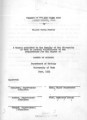
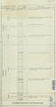
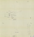
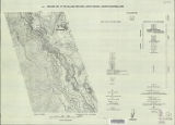
235
A study of primary sedimentary structures around the Moab anticline, Grand County, Utah (Thesis and maps)
1965-08
Text; Image
ir_etd
236
Geology of the Northern Lakeside Mountains and the Grassy Mountains and vicinity, Tooele and Box Elder Counties, Utah
1964-06
Text; Image
ir_etd
237
Geology of the Central Mineral Range, Beaver County, Utah
1957-08
Text; Image
ir_etd
238
Geology of the upper Ogden Canyon, Weber County, Utah
1960-06
Text; Image
ir_etd
239
Geology of the Big Piney area, Summit County, Utah
1953-06
Text; Image
ir_etd
240
Mineral deposits of the Deep Creek Mountains, Tooele and Juab Counties, Utah (Thesis and maps)
1970-08
Text; Image
ir_etd
241
Landslides in the Coal Hill area, Kane County, Utah (Thesis and maps)
1964-06
Text; Image
ir_etd
242
Areal geology of the Upton region, Summit County, Utah-Maps
1953-06
Image
ir_etd
243
Geology of the Sheeprock Mountains, Tooele and Juab Counties, Utah
1957-08
Text; Image
ir_etd
244
Stratigraphy of the Star Range and reconnaissance study of three selected mines-Maps
1969-06
Image
ir_etd
245
Petrology and structure of the Little Willow Series, Wasatch Mountains, Utah-Maps
1962-11
Image
ir_etd
246
Structural geology of the Willard Peak Area, North-Central Wasatch Mountains, Utah-Maps
1972-12
Image
ir_etd
247
Synvolcanic oligocene stress reorientation in Eastern Nevada: evidence from the Golden Gate range
1994-12
Text; Image
ir_etd
248
Geology of the Paria Northwest quadrangle Kane County, Utah-Maps
1970-08
Image
ir_etd
249
Parunuweap formation in the vicinity of Zion National Park, Utah-Maps
1969-06
Image
ir_etd
250
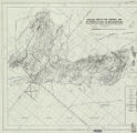
Geology of the Central and Southern silver Island Mountains Tooele County, Utah and Elko County, Nevada-Maps
1961-06
Image
ir_etd
226
-
250
of
540
<
5
6
7
8
9
10
11
12
13
14
>