In 1853 Richard Hovendon Kern was hired as topographer and artist for a government-sponsored reconnaissance led by Captain John Williams Gunnison. Kern sketched landscape panoramas as the group made its way from St. Louis toward San Francisco. When the expedition reached Sevier Lake, Utah, however, it was attacked by a band of Indians. Seven men, including Kern and Gunnison, were killed, and Kern's drawings were stolen. The sketches were soon recovered and eventually carried to Washington, D.C.
Robert Shlaer, an accomplished daguerreotypist, came across Kern's sketches many years later at the Newberry Library in Chicago. He was inspired to locate the views depicted in the drawings and to photograph them, as nearly as was possible, from the same spot where Kern had stood when he sketched them. This collection juxtaposes Kern's drawings with Shlaer's photographs, presenting 389 illustrations in geographic sequence from east to west
| Title | Alternative Title | ||
|---|---|---|---|
| 1 |
 |
Plate 292 | Elk Mts, sketch |
| 2 |
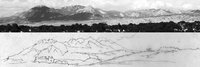 |
Plate 294 | Elk Mountains, composite sketch and photograph |
| 3 |
 |
Plate 267 | Grand River canons, sketch |
| 4 |
 |
Plate 269 | Litho: "Rock hills between Green and White Rivers: drawing: ‘Grand River Canyons' composite sketch and lithograph |
| 5 |
 |
Plate 271 | Rock hills between Green and White Rivers [Grand River Canyons], composite sketch and photograph |
| 6 |
 |
Plate 273 | Grand River canons, two superimposed drawings |
| 7 |
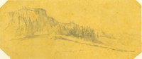 |
Plate 274 | Un-com-pah-gre Mts, sketch |
| 8 |
 |
Plate 276 | Juxtaposition of two sketches and a photograph of the slopes of Pine Creek Mesa, Uncompahgre country |
| 9 |
 |
Plate 281 | Valley of the Blue Creek, composite sketch and photograph |
| 10 |
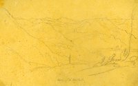 |
Plate 277 | Valley of the Cebolla Cr., sketch |
| 11 |
 |
Plate 279 | Cebolla Creek (today Blue Creek drainage) and summit of ridges south of Grand River, composite sketch and lithograph |
| 12 |
 |
Plate 282 | From Camp 62, Sept. 12th, 1853, sketch |
| 13 |
 |
Plate 284 | Camp 62, composite sketch and photograph |
| 14 |
 |
Plate 285 | Un-com-pah-gre Mts, Sept. 18th, south of Grand River, firstsketch |
| 15 |
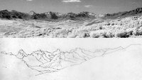 |
Plate 287 | Uncompahgre Mountains, composite of the first photograph and the first sketch |
| 16 |
 |
Plate 288 | Uncompahgre Mountains Sep. 14th [i.e. 13th], sketch |
| 17 |
 |
Plate 289 | Uncompahgre Mountains, two sketches of the same scene juxtaposed |
| 18 |
 |
Plate 268 | Rock hills between Green and White rivers, Stanley lithograph from Kern sketch |
| 19 |
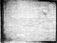 |
Plate 272 | Stanley drawing related to his lithograph of Grand (Gunnison) River canyon |
| 20 |
 |
Plate 278 | Summit of the nearest ridges south of Grand River, Stanley lithograph from Kern sketch |
| 21 |
 |
Plate 270 | Color photograph looking north from Pine Creek toward the Grand River |
| 22 |
 |
Plate 275 | Uncompahrgre country, color photograph |
| 23 |
 |
Plate 280 | Valley of the Blue Creek, photograph |
| 24 |
 |
Plate 283 | Camp 62 along US Highway 50 and the Little Cimarron River |
| 25 |
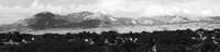 |
Plate 293 | Elk Mountains, photograph |