In 1853 Richard Hovendon Kern was hired as topographer and artist for a government-sponsored reconnaissance led by Captain John Williams Gunnison. Kern sketched landscape panoramas as the group made its way from St. Louis toward San Francisco. When the expedition reached Sevier Lake, Utah, however, it was attacked by a band of Indians. Seven men, including Kern and Gunnison, were killed, and Kern's drawings were stolen. The sketches were soon recovered and eventually carried to Washington, D.C.
Robert Shlaer, an accomplished daguerreotypist, came across Kern's sketches many years later at the Newberry Library in Chicago. He was inspired to locate the views depicted in the drawings and to photograph them, as nearly as was possible, from the same spot where Kern had stood when he sketched them. This collection juxtaposes Kern's drawings with Shlaer's photographs, presenting 389 illustrations in geographic sequence from east to west
| Title | Alternative Title | ||
|---|---|---|---|
| 1 |
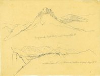 |
Plate 185 | Camp Rock (Eagle Tail); Main chain, Sierra Blanca, eastern slope (two sketches) |
| 2 |
 |
Plate 173 | Two sketches of cliff areas |
| 3 |
 |
Plate 195 | Sah-watch Mountains, composite sketch and photograph |
| 4 |
 |
Plate 197 | Rock outcrop, composite sketch and photograph |
| 5 |
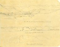 |
Plate 203 | Three sketches with minimally helpful titles drawn on one sheet by Richard Kern from near Gunnison, CO, along Cochetopa (Tomichi) Creek near its junction with the Grand (today Gunnison) River. |
| 6 |
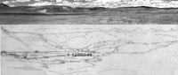 |
Plate 205 | Composite sketch and photograph of the view down Razor Creek Valley as it joins Cochetopa Creek |
| 7 |
 |
Plate 206 | Western slopes of Sah-Watch Mts, sketch |
| 8 |
 |
Plate 262 | Canon on Grand R, sketch |
| 9 |
 |
Plate 263 | Grand R. canons, sketch |
| 10 |
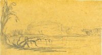 |
Plate 264 | Grand River, sketch |
| 11 |
 |
Plate 265 | Grand River, sketch |
| 12 |
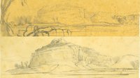 |
Plate 266 | Grand River, two sketches |
| 13 |
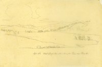 |
Plate 164 | West end of Coo-che-to-pa Pass on Pass Creek, Sept. 3rd (sketch) |
| 14 |
 |
Plate 166 | West end of Cochetopa Pass, composite sketch and photograph |
| 15 |
 |
Plate 167 | Pass Creek, sketch |
| 16 |
 |
Plate 169 | Pass Creek, composite sketch and photograph |
| 17 |
 |
Plate 174 | Divide between the waters of the Gulf of Mexico and the Pacific Ocean, sketch |
| 18 |
 |
Plate 176 | Divide between the waters of the Gulf of Mexico and the Pacific Ocean, composite sketch and photograph |
| 19 |
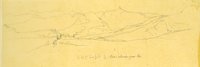 |
Plate 177 | Looking down Razor Creek Valley to Cochetopa (today Tomichi) Creek. |
| 20 |
 |
Plate 178 | Two drawings: Valley of Cochetopa (today, Tomichi) Creek, Sept. 3; Saw-watch Mtns, Sept. 5th |
| 21 |
 |
Plate 180 | Cochetopa Creek, composite drawing and photograph |
| 22 |
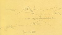 |
Plate 181 | Divide between the Gulf of Mexico and the Pacific Ocean, sketch |
| 23 |
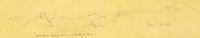 |
Plate 182 | Divide between the Gulf of Mexico and the Pacific Ocean, sketch |
| 24 |
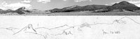 |
Plate 184 | Divide between the Gulf of Mexico and the Pacific Ocean, composite sketch and photograph |
| 25 |
 |
Plate 187 | Camp Rock (Eagle Tail) near camp, Sept. 3rd, sketch |