Home
Browse
Ask Us
Chat
Harmful Language Statement
Log in
Advanced Search
Year
1945
1946
1947
1948
1949
1950
1951
1952
1953
1954
1955
1956
1957
1958
1959
1960
1961
1962
1963
1964
1965
1966
1967
1968
1969
1970
1971
1972
1973
1974
1975
1976
1977
1978
1979
1980
1981
1982
1983
1984
1985
1986
1987
1988
1989
1990
1991
1992
1993
1994
1995
1996
1997
1998
1999
2000
2001
2002
2003
2004
2005
2006
2007
2008
2009
2010
2011
2012
2013
2014
2015
2016
TO
1945
1946
1947
1948
1949
1950
1951
1952
1953
1954
1955
1956
1957
1958
1959
1960
1961
1962
1963
1964
1965
1966
1967
1968
1969
1970
1971
1972
1973
1974
1975
1976
1977
1978
1979
1980
1981
1982
1983
1984
1985
1986
1987
1988
1989
1990
1991
1992
1993
1994
1995
1996
1997
1998
1999
2000
2001
2002
2003
2004
2005
2006
2007
2008
2009
2010
2011
2012
2013
2014
2015
2016
Type
Image/StillImage
13
Text
1
Format
image/jpeg
11
application/pdf
3
Collection
Theses & Dissertations
1
Uintah County Regional History Center...
13
Filters:
Subject:
"Geologic Map"
1
-
25
of
14
Gallery view
Number of results to display per page
10
25
50
100
200
Sort by Relevance
Sort by Title A-Z
Sort by Title Z-A
Sort by Date Ascending
Sort by Date Descending
Sort by Last Modified Ascending
Sort by Last Modified Descending
Title
Date
Type
Setname
1
Cat Creek & Pebble Puppy Placer Gold Claims, Uintah County, Utah 1994
1994
Image/StillImage
ucl_maps
2
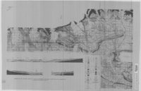
Geologic Map and Structure Sections of the Uinta River-Brush Creek Area, Duchesne and Uintah Counties, Utah
1947
Image/StillImage
ucl_maps
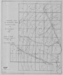
3
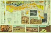
Geologic Map of Bonanza Area, Uintah County, Utah 1976
1976
Image/StillImage
ucl_maps
4
Geologic Map of the Blue Mountain Area 1963
1963
Image/StillImage
ucl_maps
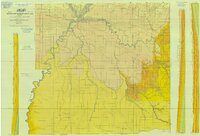
5
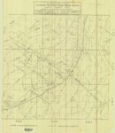
Geologic Map of Uintah County, Utah - North Half - 1950s
1950; 1951; 1952; 1953; 1954; 1955; 1956; 1957; 1958; 1959
Image/StillImage
ucl_maps
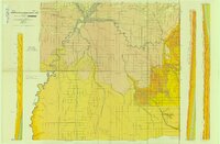
6
Geologic Map of Uintah County, Utah - South Half - 1950s
1950; 1951; 1952; 1953; 1954; 1955; 1956; 1957; 1958; 1959
Image/StillImage
ucl_maps
7
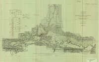
Geologic North-South Cross Profile Whiterocks Area 1957
1957
Image/StillImage
ucl_maps
8
Geological Map of Uintah County, Utah - North Half - 1950s
1950; 1951; 1952; 1953; 1954; 1955; 1956; 1957; 1958; 1959
Image/StillImage
ucl_maps
9
Geological Map of Uintah County, Utah - South Half - 1950s
1950; 1951; 1952; 1953; 1954; 1955; 1956; 1957; 1958; 1959
Image/StillImage
ucl_maps
10
Gilsonite Vein System - Geologic Map of the Ute Area
1977
Image/StillImage
ucl_maps
11
Index To Geologic Atlas of Utah - Daggett County - 1950s
1950; 1951; 1952; 1953; 1954; 1955; 1956; 1957; 1958; 1959
Image/StillImage
ucl_maps
12
Map Showing Geologic Structure of Rainbow - Bonanza - Black Dragon Areas, Uintah County, Utah
1978
Image/StillImage
ucl_maps
13
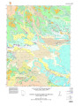
Topographic Map of the Dinosaur National Monument, Colorado - Utah, 1951
1945; 1951
Image/StillImage
ucl_maps
14
Torrey Plate 1
2016
Text
ir_etd
1
-
25
of
14