Home
Browse
Ask Us
Chat
Harmful Language Statement
Log in
Advanced Search
Year
1847
1848
1849
1850
1851
1852
1853
1854
1855
1856
1857
1858
1859
1860
1861
1862
1863
1864
1865
1866
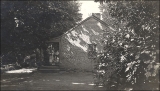
1867
1868
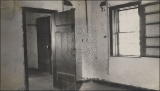
1869
1870
1871
1872
1873
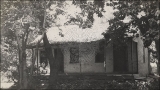
1874
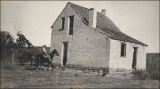
1875
1876
1877
1878
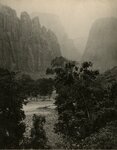
1879
1880
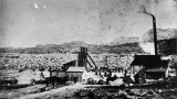
1881
1882
1883
1884
1885
1886
1887
1888
1889
1890
1891
1892
1893
1894
1895
1896
1897
1898
1899
1900
1901
1902
1903
1904
1905
1906
1907
1908
1909
1910
1911
1912
1913
1914
1915
1916
1917
1918
1919
1920
1921
1922
1923
1924
1925
1926
1927
1928
1929
1930
1931
1932
1933
1934
1935
1936
1937
1938
1939
1940
1941
1942
1943
1944
1945
1946
1947
1948
1949
1950
1951
1952
1953
1954
1955
1956
1957
1958
1959
1960
1961
1962
1963
1964
1965
1966
1967
1968
1969
1970
1971
1972
1973
1974
1975
1976
1977
1978
1979
1980
1981
1982
1983
1984
1985
1986
1987
1988
1989
1990
1991
1992
1993
1994
1995
1996
1997
1998
1999
2000
2001
2002
2003
2004
2005
2006
2007
2008
2009
2010
TO
1847
1848
1849
1850
1851
1852
1853
1854
1855
1856
1857
1858
1859
1860
1861
1862
1863
1864
1865
1866
1867
1868
1869
1870
1871
1872
1873
1874
1875
1876
1877
1878
1879
1880
1881
1882
1883
1884
1885
1886
1887
1888
1889
1890
1891
1892
1893
1894
1895
1896
1897
1898
1899
1900
1901
1902
1903
1904
1905
1906
1907
1908
1909
1910
1911
1912
1913
1914
1915
1916
1917
1918
1919
1920
1921
1922
1923
1924
1925
1926
1927
1928
1929
1930
1931
1932
1933
1934
1935
1936
1937
1938
1939
1940
1941
1942
1943
1944
1945
1946
1947
1948
1949
1950
1951
1952
1953
1954
1955
1956
1957
1958
1959
1960
1961
1962
1963
1964
1965
1966
1967
1968
1969
1970
1971
1972
1973
1974
1975
1976
1977
1978
1979
1980
1981
1982
1983
1984
1985
1986
1987
1988
1989
1990
1991
1992
1993
1994
1995
1996
1997
1998
1999
2000
2001
2002
2003
2004
2005
2006
2007
2008
2009
2010
Type
Image
483
Image/StillImage
279
Text
52
Sound
46
Image/MovingImage
3
Format
image/jpeg
833
application/pdf
78
audio/mpeg
30
video/mp4
19
Collection
Beckwith Photograph Collection
45
College of Law Publications
1
Hiram B. Clawson Papers
4
Home Movie Collection
3
Jacob Myers Sr. Papers, 1801-2009
1
Photo Archives
611
Ski and Snow Sports Archives
13
UAIDA Main Collection
19
Uintah County Regional History Center...
1
Utah Humanities Research Foundation
23
Utah Quilt Heritage Records
6
Utah River Running Photo Archives
164
Western Soundscape
46
Western Waters NEH
16
Westminster College Photographs
24
More
Filters:
Spatial Coverage:
"Washington County (Utah)"
26
-
50
of
977
<
1
2
3
4
5
6
7
8
9
10
>
Gallery view
Number of results to display per page
10
25
50
100
200
Sort by Relevance
Sort by Title A-Z
Sort by Title Z-A
Sort by Date Ascending
Sort by Date Descending
Sort by Last Modified Ascending
Sort by Last Modified Descending
Title
Date
Type
Setname
26
"Old Johnson property, St. George."
1909-09
uum_map
27
"Old Johnson property, St. George."
1909-09
uum_map
28
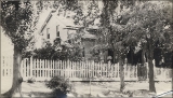
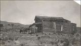
"Old Johnson store, St. George."
1909-09
uum_map
29
"Remnants of Silver Reef, Utah. "How are the mighty fallen" 1909." Rufus D. Johnson on porch.
1909-09
uum_map
30
"Shrine of Art" the farm house interior. Owned by John E. Page.
1909-09
uum_map
31
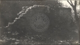
"Silver Reef, Utah [cemetery]."
1909-09
uum_map
32
"Southern Utah - Johnson's Canyon"
1909-09
uum_map
33
"Southern Utah - near Johnson's Canyon"
1909-09
uum_map
34
"Sugar Loaf."
1909-09
uum_map
35
"The farm house - now owned by John E. Page."
1909-09-13
uum_map
36
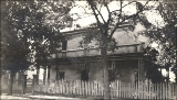
"The old Johnson home at St. George."
1909-09
uum_map
37
"The old Johnson home at St. George."
1909-09
uum_map
38
"The old Johnson home at St. George."
1909-09
uum_map
39
"The old Johnson home at St. George."
1909-09
uum_map
40
"Triangle," Zion National Park
1920; 1921; 1922; 1923
uum_map
41
A basin range, Toquerville region, 190
1900
Image
uum_map
42
Activity at an unidentified mill in Silver Reef, Utah.
1875; 1876; 1877; 1878; 1879; 1880; 1881; 1882; 1883; 1884; 1885; 1886; 1887; 1888; 1889; 1890
uum_map
43
Agriculture under irrigation in the basin of Virgin River
1903
Text
wwdl_neh
44
Albert Hubert, rockhound, Springdale, Utah, l950 [01]
1950
Image
uum_map
45
Albert Hubert, rockhound, Springdale, Utah, l950 [02]
1950
Image
uum_map
46
Allen-Warner Valley Energy System Environmental Impact Statement
1980
Text
uaida_main
47
Along road to West Rim trailhead, Zion
1966-07-05
Image
uum_map
48
Ancient gravels, (left center) form terrace both sides of Virgin River between Rockville and Grafton. Rest unconformably on middle Moenkopi beds, upper Moenkopi, Shinarump, Chinle, and Navajo above. Washington County, UT, 1939
1939
Image
uum_map
49
Ancient talus (right foreground) and talus now forming at base of Kinesava mountain, Zion National Park, Washington County, UT, 1939
1939
Image
uum_map
50
Angels Landing trail, switchback, Zion
1959-06-24
Image
uum_map
26
-
50
of
977
<
1
2
3
4
5
6
7
8
9
10
>