Home
Browse
Ask Us
Chat
Harmful Language Statement
Log in
Advanced Search
Year
1872
1873
1874
1875
1876
1877
1878
1879
1880
1881
1882
1883
1884
1885
1886
1887
1888
1889
1890
1891
1892
1893
1894
1895
1896
1897
1898
1899
1900
1901
1902
1903
1904
1905
1906
1907
1908
1909
1910
1911
1912
1913
1914
1915
1916
1917
1918
1919
1920
1921
1922
1923
1924
1925
1926
1927
1928
1929
1930
1931
1932
1933
1934
1935
1936
1937
1938
1939
1940
1941
1942
1943
1944
1945
1946
1947
1948
1949
1950
1951
1952
1953
1954
1955
1956
1957
1958
1959
1960
1961
1962
1963
1964
1965
1966
1967
1968
1969
1970
1971
1972
1973
1974
1975
1976
1977
1978
1979
1980
1981
1982
1983
1984
1985
1986
1987
1988
1989
1990
1991
1992
1993
1994
1995
1996
1997
1998
1999
2000
2001
2002
2003
2004
2005
2006
2007
2008
2009
2010
TO
1872
1873
1874
1875
1876
1877
1878
1879
1880
1881
1882
1883
1884
1885
1886
1887
1888
1889
1890
1891
1892
1893
1894
1895
1896
1897
1898
1899
1900
1901
1902
1903
1904
1905
1906
1907
1908
1909
1910
1911
1912
1913
1914
1915
1916
1917
1918
1919
1920
1921
1922
1923
1924
1925
1926
1927
1928
1929
1930
1931
1932
1933
1934
1935
1936
1937
1938
1939
1940
1941
1942
1943
1944
1945
1946
1947
1948
1949
1950
1951
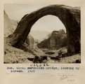
1952
1953
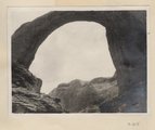
1954
1955
1956
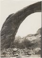
1957
1958
1959
1960
1961
1962
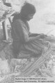
1963
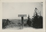
1964
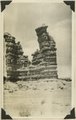
1965
1966
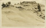
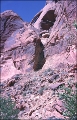
1967
1968
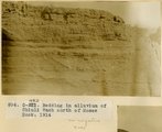
1969
1970
1971
1972
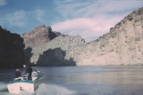
1973
1974
1975
1976
1977
1978
1979
1980
1981
1982
1983
1984
1985
1986
1987
1988
1989
1990
1991
1992
1993
1994
1995
1996
1997
1998
1999
2000
2001
2002
2003
2004
2005
2006
2007
2008
2009
2010
Type
Image
1,955
Image/StillImage
1,542
Text
286
Image/MovingImage
5
Sound
1
Format
image/jpeg
3,365
application/pdf
727
video/mp4
5
audio/mpeg
1
Collection
Beckwith Photograph Collection
2
Home Movie Collection
5
Photo Archives
1,412
Ski and Snow Sports Archives
43
UAIDA Main Collection
948
Utah Humanities Research Foundation
25
Utah Quilt Heritage Records
2
Utah River Running Photo Archives
1,665
Western Soundscape
1
Western Waters NEH
1
More
Filters:
Spatial Coverage:
"San Juan County (Utah)"
226
-
250
of
4,104
<
5
6
7
8
9
10
11
12
13
14
>
Gallery view
Number of results to display per page
10
25
50
100
200
Sort by Relevance
Sort by Title A-Z
Sort by Title Z-A
Sort by Date Ascending
Sort by Date Descending
Sort by Last Modified Ascending
Sort by Last Modified Descending
Title
Date
Type
Setname
226
Barohoini Bridge, 1910
1910
Image
uum_map
227
Barohoini Bridge, 1910
1910
Image
uum_map
228
Barohoini Bridge, looking downstream, i.e. northwest, 1910 (Photo G178A)
1910
Image
uum_map
229
Barohoini Bridge, looking downstream, i.e. northwest, 1910 (Photo G178A)
1910
Image
uum_map
230
Barohoini Bridge, looking upstream, 1910
1910
Image
uum_map
231
Barohoini Bridge, looking upstream, 1910 (Photo G179)
1910
Image
uum_map
232
Barohoini Bridge, looking upstream, 1910 (Photo G179)
1910
Image
uum_map
233
Barohoini Bridge, northeast arch, 1910 (Photo G180)
1910
Image
uum_map
234
Barohoini Bridge, northeast arch, 1910 (Photo G180)
1910
Image
uum_map
235
Barohoini Bridge, top of arch, 1910 (Photo N-M100)
1910
Image
uum_map
236
Barohoini Natural Bridge, 10+ mi. northwest of Navajo Mt., Utah in LaPlata strata, 1910. Looking down stream northwest from distance of 1+ mi. (Photo G176)
1910
Image
uum_map
237
Base of main abutment, Rainbow Bridge
1963-04-25
Image
uum_map
238
Base of northeast arch of Barohoini Bridge, 1910 (Photo G182)
1910
Image
uum_map
239
Basket maker splitting willows; Allen Canyon, San Juan County, Utah
1935
Image/StillImage
uaida_main
240
Bears Ears sign
1930
Image
uum_map_rr
241
Bears Ears southwest of Blue Mountains. Two isolated similarly shaped outliers of Wingate sandstone underlain by the Chinle formation and resting on broad bench form of Shinarump conglomerate
1927
Image
uum_map
242
Bears Ears southwest of Blue Mountains. Two isolated similarly shaped outliers of Wingate sandstone underlain by the Chinle formation and resting on broad bench form of Shinarump conglomerate
1927
Image
uum_map
243
Bears Ears views from the south cliffs are Chinle, capped by Wingate, foreground is Shinarump. Elk Ridge, San Juan County, UT, 1925
1925
Image
uum_map
244
Bears Ears views from the south cliffs are Chinle, capped by Wingate, foreground is Shinarump. Elk Ridge, San Juan County, UT, 1925
1925
Image
uum_map
245
Bedding in alluvium of Chinli Wash north of Moses Rock, 1914
1914
Image
uum_map
246
Beds lying with unconformity immediately on top of massive Bluff sandstone near mouth of Recapture Creek, San Juan County, Utah, 1929.
1929
Image
uum_map
247
Beekman's Arch in Aztec Canyon
1957; 1958; 1959; 1960; 1961; 1962
uum_map_rr
248
Beginning of trail hike to top of Bridge
1957; 1958; 1959; 1960; 1961; 1962
uum_map_rr
249
Below Moab; Don & Jack's boats
1965
Image
uum_map_rr
250
Below Moab; Don Harris' boat
1965
Image
uum_map_rr
226
-
250
of
4,104
<
5
6
7
8
9
10
11
12
13
14
>