Home
Browse
Ask Us
Chat
Harmful Language Statement
Log in
Advanced Search
Year
1849
1850
1851
1852
1853
1854
1855
1856
1857
1858
1859
1860
1861
1862
1863
1864
1865
1866
1867
1868
1869
1870
1871
1872
1873
1874
1875
1876
1877
1878
1879
1880
1881
1882
1883
1884
1885
1886
1887
1888
1889
1890
1891
1892
1893
1894
1895
1896
1897
1898
1899
1900
1901
1902
1903
1904
1905
1906
1907
1908
1909
1910
1911
1912
1913
1914
1915
1916
1917
1918
1919
1920
1921
1922
1923
1924
1925
1926
1927
1928
1929
1930
1931
1932
1933
1934
1935
1936
1937
1938
1939
1940
1941
1942
1943
1944
1945
1946
1947
1948
1949
1950
1951
1952
1953
1954
1955
1956
1957
1958
1959
1960
1961
1962
1963
1964
1965
1966
1967
1968
1969
1970
1971
1972
1973
1974
1975
1976
1977
1978
1979
1980
1981
1982
1983
1984
1985
1986
1987
1988
1989
1990
1991
1992
1993
1994
1995
1996
1997
1998
1999
2000
2001
2002
2003
2004
2005
2006
2007
2008
2009
2010
2011
2012
2013
2014
2015
2016
2017
2018
2019
2020
2021
2022
2023
TO
1849
1850
1851
1852
1853
1854
1855
1856
1857
1858
1859
1860
1861
1862
1863
1864
1865
1866
1867
1868
1869
1870
1871
1872
1873
1874
1875
1876
1877
1878
1879
1880
1881
1882
1883
1884
1885
1886
1887
1888
1889
1890
1891
1892
1893
1894
1895
1896
1897
1898
1899
1900
1901
1902
1903
1904
1905
1906
1907
1908
1909
1910
1911
1912
1913
1914
1915
1916
1917
1918
1919
1920
1921
1922
1923
1924
1925
1926
1927
1928
1929
1930
1931
1932
1933
1934
1935
1936
1937
1938
1939
1940
1941
1942
1943
1944
1945
1946
1947
1948
1949
1950
1951
1952
1953
1954
1955
1956
1957
1958
1959
1960
1961
1962
1963
1964
1965
1966
1967
1968
1969
1970
1971
1972
1973
1974
1975
1976
1977
1978
1979
1980
1981
1982
1983
1984
1985
1986
1987
1988
1989
1990
1991
1992
1993
1994
1995
1996
1997
1998
1999
2000
2001
2002
2003
2004
2005
2006
2007
2008
2009
2010
2011
2012
2013
2014
2015
2016
2017
2018
2019
2020
2021
2022
2023
Type
Image/StillImage
2,931
Image
2,504
Text
294
Sound
147
Image/MovingImage
9
Format
image/jpeg
5,249
application/pdf
587
video/mp4
112
audio/mpeg
44
Collection
Al W. Morton Collection, 1930s-1950s
55
American Westward Migration
3
Audio-Visual Archives Collections
2
Beckwith Photograph Collection
6
Classified Photographs
336
College of Law Publications
1
Everett L. Cooley Oral History Project
1
George A. Smith Papers
1
Glen Canyon
1
Land Use - Transportation Scenario Pl...
4
Mormon Settlement in Arizona
212
Photo Archives
1,942
Shipler Commercial Photographers
2
Ski and Snow Sports Photo Archives
7
UAIDA Main Collection
141
Uintah County Regional History Center...
3
Utah Artists Project
2
Utah Humanities Research Foundation
5
Utah River Running Photo Archives
3,002
Vernal Express Photographs
1
Vertebrate Zoology Voucher Images
141
Western Soundscape
152
Western Waters Documents
2
Western Waters Electronic Resources
38
More
Filters:
Spatial Coverage:
"Arizona"
1201
-
1225
of
6,060
<
44
45
46
47
48
49
50
51
52
53
>
Gallery view
Number of results to display per page
10
25
50
100
200
Sort by Relevance
Sort by Title A-Z
Sort by Title Z-A
Sort by Date Ascending
Sort by Date Descending
Sort by Last Modified Ascending
Sort by Last Modified Descending
Title
Date
Type
Setname
1201
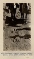
Dinosaur tracks (Stephen Janus photo, 1909. Same locality as G185)
1909
Image
uum_map
1202
Dinosaur tracks (Stephen Janus photo, 1909. Same locality as G185)
1909
Image
uum_map
1203
Dinosaur Tracks p.2
Image
dha_cp
1204
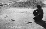
Dinosaur tracks, Navajo Canyon (Photo Hopkins, Salt Lake City)
1910
Image
uum_map
1205
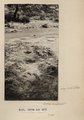
Dinosaur tracks, Navajo Canyon, Ariz., 1910 (Photo G185)
1910
Image
uum_map
1206
Dinosaur tracks, Navajo Canyon, Ariz., 1910 (Photo G185)
1910
Image
uum_map
1207
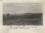
Distant (6 mi.) view of Agathla [that is, Chaezkla] from southwest (Photo G344)
1913
Image
uum_map
1208
Distant view of Chaezkla [that is, Agathla] (3 mi.) and Comb with dike (7 mi.). Dolores foreground (Photo G345)
1913
Image
uum_map
1209
Distant view, W. Kaibab Fault, 1900
1900
Image
uum_map
1210
Dixie US DOI BLM 1977
1977
Image/StillImage
ucl_maps
1211
Dock Marston, breakfast table, Cliff Dweller's
1965-06
Image
uum_map_rr
1212
Dock Marston, Jimmy Jordan, Cliff Dwellers Lodge
1965-06
Image
uum_map_rr
1213
Dock Marston, Jimmy Jordan, Cliff Dwellers Lodge
1965-06
Image
uum_map_rr
1214
Dolores and La Plata looking southeast to Tsenakahn (I-48 in film book also like this) (Photo N-M155)
1913
Image
uum_map
1215
Dolores Badlands 1 1/2 mile west of Nashlini. (I-5 & I-7 in film book just like this) (Photo N-M135)
1913
Image
uum_map
1216
Dolores Badlands 1 1/2 mile west of Nashlini. (I-5 & I-7 in film book just like this) (Photo N-M135)
1913
Image
uum_map
1217
Dolores Badlands west of Nashlini (Photo N-M136)
1913
Image
uum_map
1218
Dolores below Tse-na-kahn. East side of Chin lee wash
1913
Image
uum_map
1219
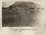
Dolores Butte, Carrizo Creek Wash (Photo G450)
1913
Image
uum_map
1220
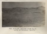
Dolores cliff 8± mi. north of Tolchaco (IX-3-4) (Photo N-M172)
1913
Image
uum_map
1221
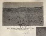
Dolores cliff 8± mioles north of Tolchaco (Photo G409)
1913
Image
uum_map
1222
Dolores east of Black Falls
1913
Image
uum_map
1223
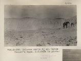
Dolores marls 8± mi. below Tanner's Spgs. E.C.Case in photo (Photo G398)
1913
Image
uum_map
1224
Dolores section, 5± mi. N 80° E, Black Falls (No. 2 etc. of Section IX-13) (Photo G424)
1913
Image
uum_map
1225
Dolores shales and marls, 2± mi. above Round Rock store on Carriso Creek at Plue Point (Pish-dot-klish-is-a). VII, 40 (Photo G276)
1911
Image
uum_map
1201
-
1225
of
6,060
<
44
45
46
47
48
49
50
51
52
53
>