In 1853 Richard Hovendon Kern was hired as topographer and artist for a government-sponsored reconnaissance led by Captain John Williams Gunnison. Kern sketched landscape panoramas as the group made its way from St. Louis toward San Francisco. When the expedition reached Sevier Lake, Utah, however, it was attacked by a band of Indians. Seven men, including Kern and Gunnison, were killed, and Kern's drawings were stolen. The sketches were soon recovered and eventually carried to Washington, D.C.
Robert Shlaer, an accomplished daguerreotypist, came across Kern's sketches many years later at the Newberry Library in Chicago. He was inspired to locate the views depicted in the drawings and to photograph them, as nearly as was possible, from the same spot where Kern had stood when he sketched them. This collection juxtaposes Kern's drawings with Shlaer's photographs, presenting 389 illustrations in geographic sequence from east to west
Filters: Collection: "uu_rkfws"
| Title | Alternative Title | ||
|---|---|---|---|
| 1 |
 |
Full Route Map 25% | Explorations and surveys for a rail road route from the Mississippi River to the Pacific Ocean: route near the 38th and 39th parallels: composite of maps 1 to 4 (copy 1) |
| 2 |
 |
Full Route Map 480px h | Explorations and surveys for a rail road route from the Mississippi River to the Pacific Ocean: route near the 38th and 39th parallels: composite of maps 1 to 4 (copy 2) |
| 3 |
 |
Full Route Map 50% | Explorations and surveys for a rail road route from the Mississippi River to the Pacific Ocean: route near the 38th and 39th parallels: composite of maps 1 to 4 (copy 3) |
| 4 |
 |
Map 1 | Explorations and surveys for a rail road route from the Mississippi River to the Pacific Ocean: route near the 41st parallel, Map no. 1, from the valley of the Green River to the Great Salt Lake, from explorations and surveys... by Capt. E. G. Beckwith, 3d Artillery (copy 2) |
| 5 |
 |
Map 1 25% | Explorations and surveys for a rail road route from the Mississippi River to the Pacific Ocean: route near the 41st parallel, Map no. 1, from the valley of the Green River to the Great Salt Lake, from explorations and surveys... by Capt. E. G. Beckwith, 3d Artillery (copy 1) |
| 6 |
 |
Map 4 | Explorations and surveys for a rail road route from the Mississippi River to the Pacific Ocean: route near the 41st paralle, Map no. 4, from the valley of the Mud Lakes to the Pacific Ocean, from explorations and surveys... by Capt. E. G. Beckwith, 3d Artillery |
| 7 |
 |
Map 4 25% | Explorations and surveys for a rail road route from the Mississippi River to the Pacific Ocean: route near the 41st paralle, Map no. 4, from the valley of the Mud Lakes to the Pacific Ocean, from explorations and surveys... by Capt. E. G. Beckwith, 3d Artillery |
| 8 |
 |
Plate 1 | Richard Hovendon Kern |
| 9 |
 |
Plate 10 | Uniontown, Kaw River |
| 10 |
 |
Plate 100 | Panoramic photograph, Sangre de Cristo Range from near site of Fort Valdez |
| 11 |
 |
Plate 101 | Panorama composite, sketches and photograph, Sangre de Cristo Range from near site of Fort Valdez |
| 12 |
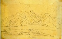 |
Plate 102 | Sierra Blanca sketch |
| 13 |
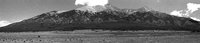 |
Plate 103 | Sierra Blanca photograph |
| 14 |
 |
Plate 104 | Sierra Blanca, composite drawing and photograph |
| 15 |
 |
Plate 105 | San Juan Mountains panoramic sketch |
| 16 |
 |
Plate 106 | San Juan Mountains panoramic photographs |
| 17 |
 |
Plate 107 | San Juan Mountains, composite drawing and photograph |
| 18 |
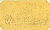 |
Plate 108 | Peaks of the Sierra Blanca, sketch |
| 19 |
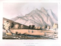 |
Plate 109 | Peaks of the Sierra Blanca, Stanley lithograph from Kern sketch |
| 20 |
 |
Plate 11 | Fort Centre or Riley, junction of Smoky Hill and Republican Fork |
| 21 |
 |
Plate 110 | Peaks of the Sierra Blanca, composite of Kern sketch and Stanley lithograph |
| 22 |
 |
Plate 111 | Juxtaposition of two Kern sketches of the peaks of the Sierra Blanca |
| 23 |
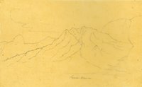 |
Plate 112 | Sierra Blanca, sketch |
| 24 |
 |
Plate 113 | Sierra Blanca, photograph |
| 25 |
 |
Plate 114 | Sierra Blanca and sand dunes, composite drawing and photograph |