In 1853 Richard Hovendon Kern was hired as topographer and artist for a government-sponsored reconnaissance led by Captain John Williams Gunnison. Kern sketched landscape panoramas as the group made its way from St. Louis toward San Francisco. When the expedition reached Sevier Lake, Utah, however, it was attacked by a band of Indians. Seven men, including Kern and Gunnison, were killed, and Kern's drawings were stolen. The sketches were soon recovered and eventually carried to Washington, D.C.
Robert Shlaer, an accomplished daguerreotypist, came across Kern's sketches many years later at the Newberry Library in Chicago. He was inspired to locate the views depicted in the drawings and to photograph them, as nearly as was possible, from the same spot where Kern had stood when he sketched them. This collection juxtaposes Kern's drawings with Shlaer's photographs, presenting 389 illustrations in geographic sequence from east to west
Filters: Collection: "uu_rkfws"
| Title | Alternative Title | ||
|---|---|---|---|
| 1 |
 |
Plate 16 | Elk Island, Arkansas, July 20th |
| 2 |
 |
Plate 379 | Madelin Pass, Shasta segment, with Shasta drawing from Mt Observation inserted |
| 3 |
 |
Plate 385 | West end of Madelin Pass, June 26, 1854, Schumann lithograph from Eggloffstein |
| 4 |
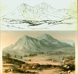 |
Plate 42 | Wah-ha-ta-gas or Spanish Peaks, composite sketch and lithograph |
| 5 |
 |
Plate 5 | Camp no. 1 |
| 6 |
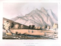 |
Plate 109 | Peaks of the Sierra Blanca, Stanley lithograph from Kern sketch |
| 7 |
 |
Plate 382 | Northern slopes of the Sierra Nevada, June 30th, 1854, Schumann lithograph from Eggloffstein |
| 8 |
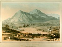 |
Plate 41 | Wah-ha-ta-gas or Spanish Peaks, Stanley lithograph from Kern sketch |
| 9 |
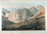 |
Plate 74 | View of Sangre de Cristo Pass, Stanley lithograph from Kern sketch |
| 10 |
 |
Full Route Map 25% | Explorations and surveys for a rail road route from the Mississippi River to the Pacific Ocean: route near the 38th and 39th parallels: composite of maps 1 to 4 (copy 1) |
| 11 |
 |
Full Route Map 480px h | Explorations and surveys for a rail road route from the Mississippi River to the Pacific Ocean: route near the 38th and 39th parallels: composite of maps 1 to 4 (copy 2) |
| 12 |
 |
Full Route Map 50% | Explorations and surveys for a rail road route from the Mississippi River to the Pacific Ocean: route near the 38th and 39th parallels: composite of maps 1 to 4 (copy 3) |
| 13 |
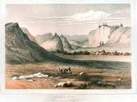 |
Plate 148 | Coo-che-to-pa Pass, color lithograph |
| 14 |
 |
Plate 242 | View of ordinary lateral ravines on Grand River (Stanley lithograph from R. H. Kern sketch) |
| 15 |
 |
Plate 378 | Madelin Pass from Mount Observation, June 19th, 1854 |
| 16 |
 |
Plate 4 | Camp No. 1 near Westport, June 20-53 |
| 17 |
 |
Map 4 25% | Explorations and surveys for a rail road route from the Mississippi River to the Pacific Ocean: route near the 41st paralle, Map no. 4, from the valley of the Mud Lakes to the Pacific Ocean, from explorations and surveys... by Capt. E. G. Beckwith, 3d Artillery |
| 18 |
 |
Plate 227 | On Twin Creek, Grand River country, sketch |
| 19 |
 |
Plate 230 | Grand River, Sept. 7th, 1853, sketch |
| 20 |
 |
Plate 233 | Sept 7th on Grand River, sketch |
| 21 |
 |
Plate 256 | View showing the formation of the Canon of Grand River, Stanley lithograph from sketch by F. W. Egloffstein |
| 22 |
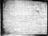 |
Plate 272 | Stanley drawing related to his lithograph of Grand (Gunnison) River canyon |
| 23 |
 |
Plate 278 | Summit of the nearest ridges south of Grand River, Stanley lithograph from Kern sketch |
| 24 |
 |
Plate 388 | Portion of the main mountain passage of the upper Sacramento of Pitt River, Schumann lithograph from Eggloffstein |
| 25 |
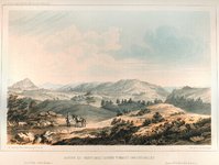 |
Plate 85 | Sangre de Cristo Pass, looking toward San Luis Valley, Stanley lithograph from Kern sketch |