In 1853 Richard Hovendon Kern was hired as topographer and artist for a government-sponsored reconnaissance led by Captain John Williams Gunnison. Kern sketched landscape panoramas as the group made its way from St. Louis toward San Francisco. When the expedition reached Sevier Lake, Utah, however, it was attacked by a band of Indians. Seven men, including Kern and Gunnison, were killed, and Kern's drawings were stolen. The sketches were soon recovered and eventually carried to Washington, D.C.
Robert Shlaer, an accomplished daguerreotypist, came across Kern's sketches many years later at the Newberry Library in Chicago. He was inspired to locate the views depicted in the drawings and to photograph them, as nearly as was possible, from the same spot where Kern had stood when he sketched them. This collection juxtaposes Kern's drawings with Shlaer's photographs, presenting 389 illustrations in geographic sequence from east to west
Filters: Collection: "uu_rkfws" Year End: 1979
| Title | Alternative Title | ||
|---|---|---|---|
| 276 |
 |
Plate 370 | Papoose sketch |
| 277 |
 |
Plate 371 | Wooded butte, sketch |
| 278 |
 |
Plate 372 | Trees, sketch |
| 279 |
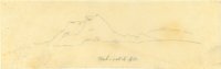 |
Plate 373 | Wah-satch Mts, sketch |
| 280 |
 |
Plate 374 | Wah-satch Mts, sketch |
| 281 |
 |
Plate 375 | Rocky Mts, sketch |
| 282 |
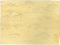 |
Plate 376 | Mount Shasta, multiple sketches |
| 283 |
 |
Plate 377 | Shasta from Mt Observation, sketch |
| 284 |
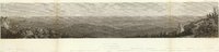 |
Plate 378 | Madelin Pass from Mount Observation, June 19th, 1854 |
| 285 |
 |
Plate 379 | Madelin Pass, Shasta segment, with Shasta drawing from Mt Observation inserted |
| 286 |
 |
Plate 380 | Shasta, 12-19_June, sketch |
| 287 |
 |
Plate 381 | Madelin Pass, Shasta segment, with Shasta drawing inserted |
| 288 |
 |
Plate 382 | Northern slopes of the Sierra Nevada, June 30th, 1854, Schumann lithograph from Eggloffstein |
| 289 |
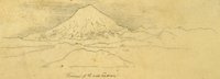 |
Plate 383 | From First Canon, sketch |
| 290 |
 |
Plate 384 | Shasta, composite of engraving, sketch, and photograph |
| 291 |
 |
Plate 385 | West end of Madelin Pass, June 26, 1854, Schumann lithograph from Eggloffstein |
| 292 |
 |
Plate 386 | Shasta, 3-26 June |
| 293 |
 |
Plate 387 | West end of Madelin Pass, composite engraving with Shasta sketch |
| 294 |
 |
Plate 388 | Portion of the main mountain passage of the upper Sacramento of Pitt River, Schumann lithograph from Eggloffstein |
| 295 |
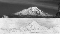 |
Plate 389 | Shasta, composite of photograph and sketch from Camp 27 and 28 |
| 296 |
 |
Map 4 25% | Explorations and surveys for a rail road route from the Mississippi River to the Pacific Ocean: route near the 41st paralle, Map no. 4, from the valley of the Mud Lakes to the Pacific Ocean, from explorations and surveys... by Capt. E. G. Beckwith, 3d Artillery |
| 297 |
 |
Map 1 25% | Explorations and surveys for a rail road route from the Mississippi River to the Pacific Ocean: route near the 41st parallel, Map no. 1, from the valley of the Green River to the Great Salt Lake, from explorations and surveys... by Capt. E. G. Beckwith, 3d Artillery (copy 1) |
| 298 |
 |
Map 4 | Explorations and surveys for a rail road route from the Mississippi River to the Pacific Ocean: route near the 41st paralle, Map no. 4, from the valley of the Mud Lakes to the Pacific Ocean, from explorations and surveys... by Capt. E. G. Beckwith, 3d Artillery |
| 299 |
 |
Full Route Map 480px h | Explorations and surveys for a rail road route from the Mississippi River to the Pacific Ocean: route near the 38th and 39th parallels: composite of maps 1 to 4 (copy 2) |
| 300 |
 |
Full Route Map 25% | Explorations and surveys for a rail road route from the Mississippi River to the Pacific Ocean: route near the 38th and 39th parallels: composite of maps 1 to 4 (copy 1) |