In 1853 Richard Hovendon Kern was hired as topographer and artist for a government-sponsored reconnaissance led by Captain John Williams Gunnison. Kern sketched landscape panoramas as the group made its way from St. Louis toward San Francisco. When the expedition reached Sevier Lake, Utah, however, it was attacked by a band of Indians. Seven men, including Kern and Gunnison, were killed, and Kern's drawings were stolen. The sketches were soon recovered and eventually carried to Washington, D.C.
Robert Shlaer, an accomplished daguerreotypist, came across Kern's sketches many years later at the Newberry Library in Chicago. He was inspired to locate the views depicted in the drawings and to photograph them, as nearly as was possible, from the same spot where Kern had stood when he sketched them. This collection juxtaposes Kern's drawings with Shlaer's photographs, presenting 389 illustrations in geographic sequence from east to west
1 - 200 of 103
| Title | Alternative Title | ||
|---|---|---|---|
| 1 |
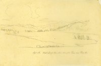 |
Plate 164 | West end of Coo-che-to-pa Pass on Pass Creek, Sept. 3rd (sketch) |
| 2 |
 |
Plate 165 | West end of Coo-che-to-pa Pass on Pass Creek, photograph |
| 3 |
 |
Plate 166 | West end of Cochetopa Pass, composite sketch and photograph |
| 4 |
 |
Plate 167 | Pass Creek, sketch |
| 5 |
 |
Plate 168 | Pass Creek, photograph |
| 6 |
 |
Plate 169 | Pass Creek, composite sketch and photograph |
| 7 |
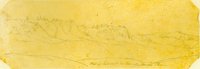 |
Plate 170 | West of summit in Cochetopa Pass, sketch |
| 8 |
 |
Plate 171 | West of summit in Cochetopa Pass, photograph |
| 9 |
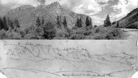 |
Plate 172 | West of summit in Cochetopa Pass, composite sketch and photograph |
| 10 |
 |
Plate 173 | Two sketches of cliff areas |
| 11 |
 |
Plate 174 | Divide between the waters of the Gulf of Mexico and the Pacific Ocean, sketch |
| 12 |
 |
Plate 175 | Divide between the waters of the Gulf of Mexico and the Pacific Ocean, photographs |
| 13 |
 |
Plate 176 | Divide between the waters of the Gulf of Mexico and the Pacific Ocean, composite sketch and photograph |
| 14 |
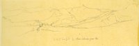 |
Plate 177 | Looking down Razor Creek Valley to Cochetopa (today Tomichi) Creek. |
| 15 |
 |
Plate 178 | Two drawings: Valley of Cochetopa (today, Tomichi) Creek, Sept. 3; Saw-watch Mtns, Sept. 5th |
| 16 |
 |
Plate 179 | The Valley of Cochetopa (today Tomichi) Creek, photograph |
| 17 |
 |
Plate 180 | Cochetopa Creek, composite drawing and photograph |
| 18 |
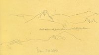 |
Plate 181 | Divide between the Gulf of Mexico and the Pacific Ocean, sketch |
| 19 |
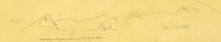 |
Plate 182 | Divide between the Gulf of Mexico and the Pacific Ocean, sketch |
| 20 |
 |
Plate 183 | Divide between the Gulf of Mexico and the Pacific Ocean, photograph |
| 21 |
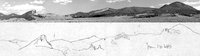 |
Plate 184 | Divide between the Gulf of Mexico and the Pacific Ocean, composite sketch and photograph |
| 22 |
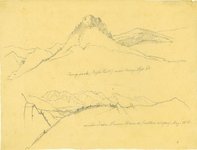 |
Plate 185 | Camp Rock (Eagle Tail); Main chain, Sierra Blanca, eastern slope (two sketches) |
| 23 |
 |
Plate 186 | Camp Rock (Eagle Tail), photograph |
| 24 |
 |
Plate 187 | Camp Rock (Eagle Tail) near camp, Sept. 3rd, sketch |
| 25 |
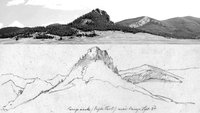 |
Plate 188 | Camp Rock (Eagle Tail), composite sketch and photograph |
| 26 |
 |
Plate 189 | Sah-watch Mts, sketch |
| 27 |
 |
Plate 190 | Tomichi Creek Valley looking east toward the mountains of the Continental Divide |
| 28 |
 |
Plate 191 | Above Tomichi Creek Valley looking toward the Saguache Mountains and the Continental Divide |
| 29 |
 |
Plate 192 | Above Tomichi Valley looking eastward to the Saguache Mountains on the Continental Divide. Composite sketch and photograph. |
| 30 |
 |
Plate 193 | Sah-watch Mts, Sept. 5, sketch |
| 31 |
 |
Plate 194 | Sah-watch Mountains, photograph |
| 32 |
 |
Plate 195 | Sah-watch Mountains, composite sketch and photograph |
| 33 |
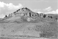 |
Plate 196 | Rock outcrop, photograph |
| 34 |
 |
Plate 197 | Rock outcrop, composite sketch and photograph |
| 35 |
 |
Plate 198 | West end of Cochetopa Pass, sketch |
| 36 |
 |
Plate 199 | Sah-watch Mts, west end of Cochetopa Pass (composite of two drawings) |
| 37 |
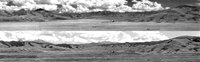 |
Plate 200 | Valley of Cochetopa Creek, two photographs |
| 38 |
 |
Plate 201 | Valley at the mouth of Cochetopa Pass, composite drawing and photograph. |
| 39 |
 |
Plate 202 | Razor Creek near its junction with Cochetopa Creek |
| 40 |
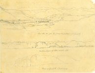 |
Plate 203 | Three sketches with minimally helpful titles drawn on one sheet by Richard Kern from near Gunnison, CO, along Cochetopa (Tomichi) Creek near its junction with the Grand (today Gunnison) River. |
| 41 |
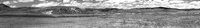 |
Plate 204 | Photograph by Robert Shlaer of lower Razor Creek |
| 42 |
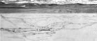 |
Plate 205 | Composite sketch and photograph of the view down Razor Creek Valley as it joins Cochetopa Creek |
| 43 |
 |
Plate 206 | Western slopes of Sah-Watch Mts, sketch |
| 44 |
 |
Plate 207 | West end of Coo-che-to-pa Pass, sketch |
| 45 |
 |
Plate 208 | Rock outcrops, sketch |
| 46 |
 |
Plate 209 | Rock outcrops, photograph |
| 47 |
 |
Plate 210 | Rock outcrops, composite sketch and photograph |
| 48 |
 |
Plate 211 | View up Grand River (first mesa), sketch |
| 49 |
 |
Plate 212 | View up Grand River (first mesa), photograph |
| 50 |
 |
Plate 213 | View up Grand River (first mesa), composite sketch and photograph |
| 51 |
 |
Plate 214 | On Grand River, sketch |
| 52 |
 |
Plate 215 | On Grand River, photograph |
| 53 |
 |
Plate 216 | On Grand River, composite sketch and photograph |
| 54 |
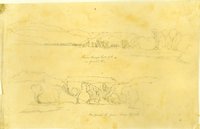 |
Plate 217 | From Camp, Sept. 7th, on Grand River (two sketches) |
| 55 |
 |
Plate 218 | From Camp, Sept. 7th, on Grand River, sketch |
| 56 |
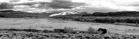 |
Plate 219 | Grand River from Sept. 7th camp, photograph |
| 57 |
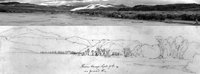 |
Plate 220 | From Camp, Sept. 7th, on Grand River, composite sketch and photograph |
| 58 |
 |
Plate 221 | On Grand River,from Camp, Sept. 7th, sketch |
| 59 |
 |
Plate 222 | On Grand River,from Camp, Sept. 7th, photograph |
| 60 |
 |
Plate 223 | On Grand River,from Camp, Sept. 7th, composite sketch and photograph |
| 61 |
 |
Plate 224 | Valley of Grand River, Sept. 8th, sketch |
| 62 |
 |
Plate 225 | Valley of Gunnison River and Blue Mesa Reservoir, photograph |
| 63 |
 |
Plate 226 | Valley of Grand River, Sept. 8th, composite sketch and photograph |
| 64 |
 |
Plate 227 | On Twin Creek, Grand River country, sketch |
| 65 |
 |
Plate 228 | On Twin Creek, Grand River country, photograph |
| 66 |
 |
Plate 229 | On Twin Creek, Grand River country, composite sketch and photograph |
| 67 |
 |
Plate 230 | Grand River, Sept. 7th, 1853, sketch |
| 68 |
 |
Plate 231 | Grand River, color photograph |
| 69 |
 |
Plate 232 | Grand River, composite sketch and photograph |
| 70 |
 |
Plate 233 | Sept 7th on Grand River, sketch |
| 71 |
 |
Plate 234 | Blue Mesa Reservoir color photograph |
| 72 |
 |
Plate 235 | Grand River, composite sketch and photograph |
| 73 |
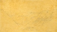 |
Plate 236 | Side valley of Grand River, sketch |
| 74 |
 |
Plate 237 | Side valley of Grand River, photograph |
| 75 |
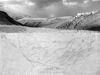 |
Plate 238 | Side valley of Grand River, composite sketch and photograph |
| 76 |
 |
Plate 239 | Affluent of Grand R, Sept 8th |
| 77 |
 |
Plate 240 | Grand River Canon, Sept 8th, 1853, sketch |
| 78 |
 |
Plate 241 | Northern slope on Grand R., Sept 8th, sketch |
| 79 |
 |
Plate 242 | View of ordinary lateral ravines on Grand River (Stanley lithograph from R. H. Kern sketch) |
| 80 |
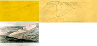 |
Plate 243 | Lateral ravines on Grand River, composite of Kern sketch and Stanley lithograph |
| 81 |
 |
Plate 244 | Grand River Canon, panoramic photograph |
| 82 |
 |
Plate 245 | Grand River canyon, composite of panoramic photograph and two sketches |
| 83 |
 |
Plate 246 | Side canyon of Grand R, sketch |
| 84 |
 |
Plate 247 | Canon of Grand River [Lake Fork], Sept 13th [i.e. 9th], sketch |
| 85 |
 |
Plate 248 | Grand River [Lake Fork] Canon , Sept 9th, sketch |
| 86 |
 |
Plate 249 | Grand River Canon , Sept 9th; Lake Fork, Sept. 10th (two sketches) |
| 87 |
 |
Plate 250 | Grand River canyon and side canyons, Sept. 9: three sketches as a panorama |
| 88 |
 |
Plate 251 | Lake Fork of the Grand River seen from Sapinero Mesa, panoramic photograph |
| 89 |
 |
Plate 252 | Lake Fork of the Grand (Gunnison) River, composite of a panoramic photograph and three adjacent sketches |
| 90 |
 |
Plate 253 | Lake Fork, Sept. 10th [i.e. 9th], sketch |
| 91 |
 |
Plate 254 | Lake Fork, photograph |
| 92 |
 |
Plate 255 | View west from Lake Fork, composite sketch and photograph |
| 93 |
 |
Plate 256 | View showing the formation of the Canon of Grand River, Stanley lithograph from sketch by F. W. Egloffstein |
| 94 |
 |
Plate 257 | Upper reaches of the Black Canyon of the Gunnison |
| 95 |
 |
Plate 258 | Sketch looking northward from Pine Creek Mesa up Salt Creek Canyon |
| 96 |
 |
Plate 259 | Salt Creek Canyon photograph |
| 97 |
 |
Plate 260 | Salt Creek Canyon, composite sketch and photograph |
| 98 |
 |
Plate 261 | Grand River Canon (leaving the river), Sept. 10th, sketch |
| 99 |
 |
Plate 262 | Canon on Grand R, sketch |
| 100 |
 |
Plate 263 | Grand R. canons, sketch |
| 101 |
 |
Plate 264 | Grand River, sketch |
| 102 |
 |
Plate 265 | Grand River, sketch |
| 103 |
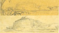 |
Plate 266 | Grand River, two sketches |
1 - 200 of 103