TO
Filters: Collection: "ir_eua"
| Title | Date | Subject | Description | ||
|---|---|---|---|---|---|
| 1 |
 |
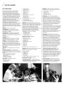
Abbreviations | |||
| 2 |
 |
Historic Fort Douglas at the University of Utah | Fort Douglas; Utah | The majority of the fort was designated a National Historic Landmark in 1970. The University of Utah Fort Douglas Heritage Commons is also an Official Project of Save America's Treasures, a public-private partnership between the White House Millennium Council and the National Trust for Historic Pres... | |
| 3 |
 |
Required Documentation 8: Campus Map | The University of Utah 2006 Self-Study Required Documentation: Standards 6-8. Standard 8: Campus Map | ||
| 4 |
 |
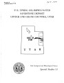
Oil-impregnated sandstones of Raven Ridge, Vernal, Utah | 1972 | Oil-impregnated sandstone; Raven Ridge; Vernal, Utah; Uinta Basin; Utah; Colorado; Wasatch Formation; Green River Formation; Uinta Formation | The area of this report is in the northeastern part of the Uinta Basin of northeastern Utah and northwestern Colorado. The area covers approximately 52 square miles of what is regionally called Raven Ridge. Raven Ridge, a series of hogback ridges, trends northwest-southeast, and includes three Eocen... |
| 5 |
 |
Points of Distinction | |||
| 6 |
 |
Points of Distinction | |||
| 7 |
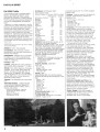 |
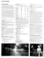
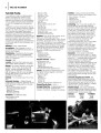
Facts in Brief | |||
| 8 |
 |
Photos | |||
| 9 |
 |
UUSAC parking request 1993-1994 | 1994 | Committees | Notes, letters and memos of the University of Utah Parking, Transportation, Traffic Modeling Project Settering Committee. |
| 10 |
 |
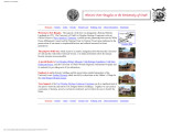
About the University of Utah | |||
| 11 |
 |
P. R. spring oil-impregnated sandstone deposit Uintah and Grand Counties, Utah | 1970-02 | oil-impregnated sandstone beds; oil impregnation; oil shale; lenticular sandstones; siltstones | Oil-impregnated sandstone beds underlie at least 214 square miles in the southeastern Uinta Basin and may extend northward beneath cover. One to as many as five principal saturated zones, 3 to 75 feet thick, occur in a 250-foot interval that dips gently northward. The northernmost outcrops are overl... |
| 12 |
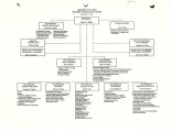 |
Body (UUSAC: Cathey Eckart Chair) | University of Utah staff | Minutes, membership, organizational charts and other committee business. | |
| 13 |
 |
Geologic summary report of the 1981 exploration program, Sunnyside Tar Sands project, Carbon County, Utah | 1982-02-19 | Geologic summary; exploration project; Sunnyside Tar Sands project; delta complex. | The 1981 Sunnyside exploration program consisted of: (1) diamond drilling of sixteen drill holes and logging of the core, and (2) initial geologic mapping in the northern area to better define the limits of the tar sands associated with the Sunnyside delta complex. In order to comprehend the geometr... |
| 14 |
 |
Field guide to lacustrine and related nonmarine depositional environments in tertiary rocks, Uinta Basin, Utah | 1976-11 | lacustrine environments; nonmarine depositional environments; tertiary rocks | The lower part of the Tertiary System in the Uinta Basin of northeastern Utah and northwestern Colorado (fig. 1) reflects a series of very complex and variable forms of continental sedimentation in a basin of internal drainage. These complex forms represent the disruption of the Cretaceous depositio... |
| 15 |
 |
Appendices | 2006-08-18 | The University of Utah in 1996: a report to the Commission on Colleges of the Northwest Association of Schools and Colleges. Appendices | |
| 16 |
 |
Staff | |||
| 17 |
 |
UUSAC publications 1997-1998 | 1998 | University of Utah newsletter; publications | University of Utah newsletters including UUSAC News, Community Forum and FYI |
| 18 |
 |
Geologic summary report of the 1989 exploration program, Sunnyside tar sands project, Carbon County, Utah | 1990-07-30 | geologic summary report; exploration program; Sunnyside tar sands project; tar sand. | This report includes the 1989 data and represents a summary of previous exploration reports. Eight photographs included in Volume I are used to highlight aspects of the Sunnyside. Tar Sands project. Volume II contains five maps and five cross sections. Volume III contains twenty-six strip logs. Both... |
| 19 |
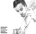 |
Research and Service Agencies | |||
| 20 |
 |
Facts in Brief | |||
| 21 |
 |
Facts in Brief | |||
| 22 |
 |
Facts in Brief | |||
| 23 |
 |
1962-63 General Catalog | 1962 | University of Utah catalogue; (Catalog) | Volume 53, Number 4, April 30, 1962. Bulletin of the University of Utah General Catalog, 1962-63 |
| 24 |
 |
Economic potential of state-owned lands in the Sunnyside Special Tar Sand Area Carbon County, Utah | 1985 | The Sunnyside oil-impregnated (tar sand) deposit is located in the southwestern portion of the Uinta Basin, approximately 25 miles east of Price, Utah (fig. 1). The tar sands are located in the Wasatch Formation and in the Douglas Creek Member of the Green River Formation, with up to 32 individual b... | |
| 25 |
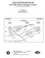 |
Tar-sand resources of the Uinta Basin, Utah: A catalog of deposits | 1996-05 | tar sand; oil-impregnated sandstone; tar sand resources; solid hydrocarbon deposits; bitumous sandstone | Tar-sand, or oil-impregnated sandstone, deposits and occurrences of the Uinta Basin, Utah are summarized and presented. Twenty five tar-sand deposits/occurrences are reviewed with respect to geology, locations of bitumen saturated outcrops, land ownership, physiography, bitumen-analyses, development... |