Filters: Collection:"ir_eua"
| Title | Date | Subject | Description | ||
|---|---|---|---|---|---|
| 1 |  | 2014-2015 General Catalog | 2015 | University of Utah catalogue; (Catalog) | Course descriptions, majors & minors, colleges & schools |
| 2 |  | Clean and Secure Energy from Domestic Oil Shale and Oil Sands Resources: Quarterly progress report - January 2015 to March 2015 | 2015 | quarterly report; domestic oil shale resources; domestic oil sands resources; unconventional fuels; oil shale; oil sands | The Clean and Secure Energy from Domestic Oil Shale and Oil Sands Resources program, part of the research agenda of the Institute for Clean and Secure Energy (ICSE) at the University of Utah, is focused on engineering, scientific, and legal research surrounding the development of these resources in ... |
| 3 |  | Clean and Secure Energy from Coal - Final report, Utah Clean Coal Program | 2015-02 | coal; Utah Clean Coal Program; domestic coal resources; CO2 capture; CO2 combustion; stationary power generation; V/UQ; oxy-coal combustion; high-pressure, entrained-flow coal gasification; chemical looping combustion; underground coal thermal treatment; mercury control; environmental issues; legal ... | The University of Utah, through their Institute for Clean and Secure Energy (ICSE), performed research to utilize the vast energy stored in our domestic coal resources and to do so in a manner that will capture CO2 from combustion from stationary power generation. The research was organized around t... |
| 4 |  | Sabbatical report (July 2015 - December 2015) | 2015-12 | Sabbitical; Oxford university; St. Stephen's House; Pusey House | Report of sabbatical leave for Peter Kraus, Marriott Library, University of Utah |
| 5 |  | Skyline 12 Fisher Assay Data | 2015-07 | Skyline 12; Fisher Assay; Drill hole | Fisher Assay drill hole info on Skyline 12. |
| 6 |  | Skyline 16 information | 2015-07 | Skyline 16; preliminary stratigraphy of Skyline 16; Green River Formation; Protecore samples | |
| 7 | | Skyline 16 sampling | 2015-07 | Skyline 16; sampling summary | Skyline 16 sampling summary. |
| 8 | 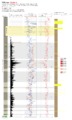 | Skyline 16 Stratigraphic Column | 2015-07 | Skyline 16; stratigraphic column; well core; core log | Well log of Skyline 16. |
| 9 | | Skyline 16 XRF | 2015-07 | Skyline 16; Skyline 16 samples | |
| 10 | 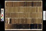 | Skyline 16: SW SW sec. 10 11S 25E Uintah County, Utah. Box 1 Depth: 20.0 - 30.0 ft. | 2015-07 | core samples; Skyline 16; box 1; Green River Formation | Core sample photograph by the Utah Geological Survey, University of Utah. Skyline 16, SW SW sec. 10 11S 25E Uintah Country, Utah. Box 1 Depth: 20.0 - 30.0 ft. |
| 11 |  | Skyline 16: SW SW sec. 10 11S 25E Uintah County, Utah. Box 10 Depth: 110.0 - 120.0 ft. | 2015-07 | core samples; Skyline 16; box 10; Green River Formation | Core sample photograph by the Utah Geological Survey, University of Utah. Skyline 16: SW SW sec. 10 11S 25E Uintah County, Utah. Box 10 Depth: 110.0 - 120.0 ft. |
| 12 |  | Skyline 16: SW SW sec. 10 11S 25E Uintah County, Utah. Box 11 Depth: 120.0 - 130.0 ft. | 2015-07 | core samples; Skyline 16; box 11; Green River Formation | Core sample photograph by the Utah Geological Survey, University of Utah. Skyline 16: SW SW sec. 10 11S 25E Uintah County, Utah. Box 11 Depth: 120.0 - 130.0 ft. |
| 13 |  | Skyline 16: SW SW sec. 10 11S 25E Uintah County, Utah. Box 12 Depth: 130.0 - 140.0 ft. | 2015-07 | core samples; Skyline 16; box 12; Green River Formation | Core sample photograph by the Utah Geological Survey, University of Utah. Skyline 16: SW SW sec. 10 11S 25E Uintah County, Utah. Box 12 Depth: 130.0 - 140.0 ft. |
| 14 | 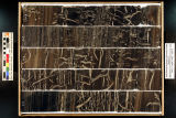 | Skyline 16: SW SW sec. 10 11S 25E Uintah County, Utah. Box 13 Depth: 140.0 - 150.0 ft. | 2015-07 | core samples; Skyline 16; box 13; Green River Formation | Core sample photograph by the Utah Geological Survey, University of Utah. Skyline 16: SW SW sec. 10 11S 25E Uintah County, Utah. Box 13 Depth: 140.0 - 150.0 ft. |
| 15 |  | Skyline 16: SW SW sec. 10 11S 25E Uintah County, Utah. Box 14 Depth: 150.0 - 160.0 ft. | 2015-07 | core samples; Skyline 16; box 14; Green River Formation | Core sample photograph by the Utah Geological Survey, University of Utah. Skyline 16: SW SW sec. 10 11S 25E Uintah County, Utah. Box 14 Depth: 150.0 - 160.0 ft. |
| 16 |  | Skyline 16: SW SW sec. 10 11S 25E Uintah County, Utah. Box 15 Depth: 160.0 - 170.0 ft. | 2015-07 | core samples; Skyline 16; box 15; Green River Formation | Core sample photograph by the Utah Geological Survey, University of Utah. Skyline 16: SW SW sec. 10 11S 25E Uintah County, Utah. Box 15 Depth: 160.0 - 170.0 ft. |
| 17 | 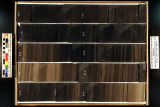 | Skyline 16: SW SW sec. 10 11S 25E Uintah County, Utah. Box 16 Depth: 170.0 - 180.0 ft. | 2015-07 | core samples; Skyline 16; box 16; Green River Formation | Core sample photograph by the Utah Geological Survey, University of Utah. Skyline 16: SW SW sec. 10 11S 25E Uintah County, Utah. Box 16 Depth: 170.0 - 180.0 ft. |
| 18 | 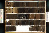 | Skyline 16: SW SW sec. 10 11S 25E Uintah County, Utah. Box 17 Depth: 180.0 - 190.0 ft. | 2015-07 | core samples; Skyline 16; box 17; Green River Formation | Core sample photograph by the Utah Geological Survey, University of Utah. Skyline 16: SW SW sec. 10 11S 25E Uintah County, Utah. Box 17 Depth: 180.0 - 190.0 ft. |
| 19 | 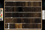 | Skyline 16: SW SW sec. 10 11S 25E Uintah County, Utah. Box 18 Depth: 190.0 - 200.0 ft. | 2015-07 | core samples; Skyline 16; box 18; Green River Formation | Core sample photograph by the Utah Geological Survey, University of Utah. Skyline 16: SW SW sec. 10 11S 25E Uintah County, Utah. Box 18 Depth: 190.0 - 200.0 ft. |
| 20 |  | Skyline 16: SW SW sec. 10 11S 25E Uintah County, Utah. Box 19 Depth: 200.0 - 210.0 ft. | 2015-07 | core samples; Skyline 16; box 19; Green River Formation | Core sample photograph by the Utah Geological Survey, University of Utah. Skyline 16: SW SW sec. 10 11S 25E Uintah County, Utah. Box 19 Depth: 200.0 - 210.0 ft. |
| 21 | 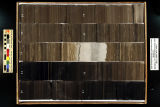 | Skyline 16: SW SW sec. 10 11S 25E Uintah County, Utah. Box 2 Depth: 30.0 - 40.0 ft. | 2015-07 | core samples; Skyline 16; box 2; Green River Formation | Core sample photograph by the Utah Geological Survey, University of Utah. Skyline 16, SW SW sec. 10 11S 25E Uintah Country, Utah. Box 2 Depth: 30.0 - 40.0 ft. |
| 22 |  | Skyline 16: SW SW sec. 10 11S 25E Uintah County, Utah. Box 20 Depth: 210.0 - 220.0 ft. | 2015-07 | core samples; Skyline 16; box 20; Green River Formation | Core sample photograph by the Utah Geological Survey, University of Utah. Skyline 16: SW SW sec. 10 11S 25E Uintah County, Utah. Box 20 Depth: 210.0 - 220.0 ft. |
| 23 |  | Skyline 16: SW SW sec. 10 11S 25E Uintah County, Utah. Box 21 Depth: 220.0 - 230.0 ft. | 2015-07 | core samples; Skyline 16; box 21; Green River Formation | Core sample photograph by the Utah Geological Survey at the University of Utah and the Utah Core Research Center. Skyline 16: SW SW sec. 10 11S 25E Uintah County, Utah. Box 21 Depth: 220.0 - 230.0 ft. |
| 24 |  | Skyline 16: SW SW sec. 10 11S 25E Uintah County, Utah. Box 22 Depth: 230.0 - 240.0 ft. | 2015-07 | core samples; Skyline 16; box 22; Green River Formation | Core sample photograph by the Utah Geological Survey at the University of Utah, and the Utah Core Research Center. Skyline 16: SW SW sec. 10 11S 25E Uintah County, Utah. Box 22 Depth: 230.0 - 240.0 ft. |
| 25 |  | Skyline 16: SW SW sec. 10 11S 25E Uintah County, Utah. Box 23 Depth: 240.0 - 250.0 ft. | 2015-07 | core samples; Skyline 16; box 23; Green River Formation | Core sample photograph by the Utah Geological Survey at the University of Utah, and the Utah Core Research Center. Skyline 16: SW SW sec. 10 11S 25E Uintah County, Utah. Box 23 Depth: 240.0 - 250.0 ft. |