TO
Filters: Collection: "ir_eua"
| Title | Date | Subject | Description | ||
|---|---|---|---|---|---|
| 1 |
 |
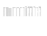
Fischer Assay Data, Utah Geological Survey Well Number U578 | 2008 | This dataset contains the results of Fischer assay analyses obtained and published by the Utah Geological Survey for well U578. | |
| 2 |
 |
Fischer Assay Data, Utah Geological Survey Well Number U423 | 2008 | This dataset contains the results of Fischer assay analyses obtained and published by the Utah Geological Survey for well U423. | |
| 3 |
 |
Fischer Assay Data, Utah Geological Survey Well Number U437 | 2008 | This dataset contains the results of Fischer assay analyses obtained and published by the Utah Geological Survey for well U437. | |
| 4 |
 |
Fischer Assay Data, Utah Geological Survey Well Number U439 | 2008 | This dataset contains the results of Fischer assay analyses obtained and published by the Utah Geological Survey for well U439. | |
| 5 |
 |
Fischer Assay Data, Utah Geological Survey Well Number U436 | 2008 | This dataset contains the results of Fischer assay analyses obtained and published by the Utah Geological Survey for well U436. | |
| 6 |
 |
Fischer Assay Data, Utah Geological Survey Well Number U435 | 2008 | This dataset contains the results of Fischer assay analyses obtained and published by the Utah Geological Survey for well U435. | |
| 7 |
 |
Fischer Assay Data, Utah Geological Survey Well Number U440 | 2008 | This dataset contains the results of Fischer assay analyses obtained and published by the Utah Geological Survey for well U440. | |
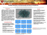
| 8 |
 |
Fischer Assay Data, Utah Geological Survey Well Number U513 | 2008 | This dataset contains the results of Fischer assay analyses obtained and published by the Utah Geological Survey for well U513. | |
| 9 |
 |
Fischer Assay Data, Utah Geological Survey Well Number U512 | 2008 | This dataset contains the results of Fischer assay analyses obtained and published by the Utah Geological Survey for well U512. | |
| 10 |
 |
Geology and genesis of the coast range province of California and its hydrocarbon deposits | 1987 | hydrocarbon deposits; tar sand; oil shale | California is along the western borderland of North America where sedimentary deposits accumulated along the eastern Pacific margin. During that time, subduction diastrophism prevailed in the late Mesozoic-early Cenozoic era, and right-lateral strike-slip shear diastrophism prevailed in the middle a... |
| 11 |
 |
Campus Magazine vol.6, no.8 | 1969 | University of Utah catalogue; (Catalog) | Fall fashions river run Lynn Leahman the association Sun Valley honeymoon |
| 12 |
 |
The Chinese wax mine: A unique oil-impregnated rock deposit | 1975 | Chinese wax mine; oil-impregnated rock deposit; oil; mineral wax; viscous oil | The Chinese Wax mine in Daniels Canyon, Wasatch County, Utah, is a small deposit of black, viscous, waxy oil emplaced in fractured, brecciated Oquirrh Formation (Pennsylvanian-Permian) on the Strawberry Valley (or Charleston) thrust sheet where the thrust has overriden the west margin of the Uinta B... |
| 13 |
 |
Demographic and socioeconomic characteristics of Salt Lake County: sub-county analysis | 2006-12 | Salt Lake County; Projections; Estimates; Aging population; Baby boom; Utah; Salt Lake Aging Services; Kennecott Land | This paper is an examination of the shifting geographic distribution of the population within Salt Lake County over time as well as an analysis of the spatial distribution of its demographic and socioeconomic characteristics. It builds on the county-level analysis included in a separate section of t... |
| 14 |
 |
Uteland Butte deposit | 1970 | Uteland Butte deposit; deposits | A description of the Uteland Butte deposit. |
| 15 |
 |
Road log no. 2 | 1963 | road log; geology of southwestern Utah | Road Log NO. 2 1.1 St. George, Utah, To Cedar City, Utah, Via Zion National Park and Cedar Breaks National Monument (216.9 Miles). |
| 16 |
 |
AJ Eardley 1935 Diary | Geology; Yukon | Geology Prof. Armand Eardley (1901-1972) accompanied Frederica De Laguna on the archaeological expedition to Alaska in the summer of 1935. At that time, he was a professor at University of Michigan, before finishing his career at University of Utah (my institution), where he was also a dean. This wa... | |
| 17 |
 |
Required Documentation 6.1: Governance and Administration, Board of Trustees | The University of Utah 2006 Self-Study Required Documentation: Standards 6-8. 6.1: Governance and Administration, Board of Trustees | ||
| 18 |
 |
Salt Lake County's distinctive demographics: implications for the aging population | 2006-12 | Salt Lake County; Projections; Estimates; Aging population; Baby boom; Utah; Salt Lake Aging Services; Kennecott Land | Salt Lake County is the economic, political, and cultural center of Utah. The county is currently home to nearly 40 percent of Utah residents and generates about half of all jobs in the state. It remains the most populous county, with a million of the state's 2.6 million residents,1 and its daytime ... |
| 19 |
 |
Energy resources map of Utah (no. 68) | 1983-05 | Map 68; Utah; Energy Resources map; Gilsonite; Oil shale; Oil-impregnated rock; Geology; Oil and natural gas | |
| 20 |
 |
Quantitative methods for reservoir characterization and improved recovery: Application to heavy oil sands | 2000-10-24 | subsurface geological characteristics; petrophysical properties; measurement of permeability; reservoir characterization | Comparison and integration of data from field investigations in southern Utah with results from Coalinga Field in California is yielding a better understanding of the distributions of subsurface geological characteristics and petrophysical properties. A new minipermeameter probe was developed for me... |
| 21 |
 |
Part 999999 | |||
| 22 |
 |
Conjunctive surface and groundwater management in Utah: Implications for oil shale and oil sands development | 2011-12-31 | Unconventional fuel development; Conjunctive water use; Surface water; Groundwater; Utah; Utah water law; Oil shale; Oil sands | Unconventional fuel development will require scarce water resources. In an environment characterized by scarcity, and where most water resources are fully allocated, prospective development will require minimizing water use and seeking to use water resources in the most efficient manner. Conjunctive... |
| 23 |
 |
The Whiterocks tar sand deposit | 1985 | Whiterocks tar sand deposit; tar sand; bitumen; tar-bearing Navajo Sandstone | The Whiterocks tar sand deposit is located near the mouth of Whiterocks Canyon, an important south drainage of the Uinta Mountains. This deposit is probably the least known and most unique of the major bitumen accumulations in the Uinta Basin. Historically, it is near the purported oldest white sett... |
| 24 |
 |
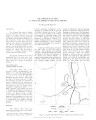
Towanta Lineament, Northern Utah | 1974-06 | Towanta Lineament; geologic mapping; mineralization; relation to ground water | A lineament, herein called the Towanta Lineament, was first noticed on a composite raised relief map of Utah and has been traced on aerial and satellite photograph)' and topographic maps for about 220 miles (350 kms.). Parrs of the eastern half have been examined in the field. The lineament extends ... |
| 25 |
 |
Atomistic modeling of oil shale kerogen and asphaltenes | 2010-04-28 | Kerogen is a mixture of organic chemical compounds that make up a portion of the organic matter in sedimentary rocks. It is insoluble in normal organic solvents because of the large molecular weight (upwards of several thousand Daltons). When heated in the Earth's crust (oil window ca. 60 ° - 120 �... |