TO
Filters: Collection: "ir_eua"
| Title | Date | Subject | Description | ||
|---|---|---|---|---|---|
| 1 |
 |
Geologic summary report of the 1986 exploration program, Sunnyside tar sands project, Carbon County, Utah--volume 1 | 1987-07-19 | geologic summary report; exploration program; Sunnyside tar sands project; hydrocarbon leases; tar sand. | The 1986 exploration program focused on detailed geological and geophysical field work in outlying areas of hydrocarbon leases east of Mt. Bartles. Field work was also completed in the Whitmore Canyon area. The field program extended from June 16 through September 19. During this time geological and... |
| 2 |
 |
Potential hydrologic impacts of a tar-sand industry in 11 special tar sand areas in eastern Utah | 1983 | crude oil tar-sand deposits; U.S. Bureau of Land Management; Tar Sand Triangle area; hydrolic impact | About 93 percent of the Nation's estimated 30 billion barrels of crude oil in tar-sand deposits is in 11 areas in eastern Utah that were chosen for leasing by the U.S. Bureau of Land Management. The largest deposit, which is in the Tar Sand Triangle area, contains about 15 billion barrels of oil. Th... |
| 3 |
 |
Geologic summary report of the 1989 exploration program, Sunnyside tar sands project, Carbon County, Utah | 1990-07-30 | geologic summary report; exploration program; Sunnyside tar sands project; tar sand. | This report includes the 1989 data and represents a summary of previous exploration reports. Eight photographs included in Volume I are used to highlight aspects of the Sunnyside. Tar Sands project. Volume II contains five maps and five cross sections. Volume III contains twenty-six strip logs. Both... |
| 4 |
 |
In-situ combustion handbook--principles and practices | 1999-01 | in-situ combustion; oil reservoir; oil recovery; field trials; fireflood projects; combustion projects | For nearly 90 years in-situ combustion technique has been used in the U.S. in attempts to improve recovery from oil reservoirs. Despite its long history and commercial success of many field projects, the process has not found widespread acceptance among operators due to the excessive number of failu... |
| 5 |
 |
Geologic summary report of the 1988 exploration program, Sunnyside Tar Sands project, Carbon County, Utah--volume 1 | 1989-06-01 | geologic summary report; exploration program; Sunnyside tar sands project; tar sand | The 1988 field program focused on completion and logging of twelve core drill holes and three measured sections. Five marker beds were established within the Parachute Creek Member and include the Wavy Bedded Tuff, Mahogany oil shale, R-5 oil shale, lower tuff and Blue Marker containing the R-2 oil ... |
| 6 |
 |
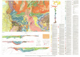
Geologic summary report of the 1987 exploration program, Sunnyside Tar Sands project, Carbon County, Utah--volume 1 | 1988-06-01 | geologic summary report; 1987 exploration program; Sunnyside Tar Sands project; tar sand distribution; tar sands; bituminous sandstones | 1. The distribution of tar sands in the Sunnyside deposit is related to both structure and lithology. The structural control is associated with a northwest trending flexure that segments a large monocline which slopes gently into the Uinta Basin. The lithologic control is determined by porous and pe... |
| 7 |
 |
Geologic summary report of the 1982 exploration program, Sunnyside Tar Sands project, Carbon County, Utah | 1983-06-30 | geologic summary report; exploration program; Sunnyside Tar Sands project; tar sands; bituminous sandstone deposits | The Sunnyside tar sands are located within the southwest portion of the Uinta Basin and localized within a small delta complex that formed in Lake Uinta during early Tertiary time. The essence of the Sunnyside tar sands deposit is a sequence of laterally continuous sheet sands or stacked bituminous ... |
| 8 |
 |
Geology of the bituminous sandstone deposits near Sunnyside, Carbon County, Utah | 1956 | geology; bituminous sandstone deposits; Sunnyside; stratigraphy; Wasatch formation; Green River formation; bitumen extraction | The bituminous sandstone deposits near Sunnyside, Carbon County, Utah, the largest known in the United States, were examined by the writers when employed by the Geological Survey, U. S. Department of the In- terior, as a collateral part of an investigation of sources of petroleum products. The ... |
| 9 |
 |
A proposed oil extraction and strip-mining project | 1974-08-23 | The Utah Division of Oil & Gas Conservation, 1588 West North Temple, Salt Lake City, Utah, has received an application from the Sohio Petroleum Company to conduct mining operations for the removal and processing of the commercially minable deposits of bituminous sands on the following described land... | |
| 10 |
 |
Geologic summary report of the 1984 exploration program, Sunnyside Tar Sands project, Carbon County, Utah--volume 1 | 1985-06 | geologic summary; exploration program; tar sands; Sunnyside tar sand deposit. | The 1984 Sunnyside exploration program consisted of: (1) diamond drilling of fifteen drill holes, (2) logging of all core and (3) additional geological mapping in the north area to better define the limits of the tar sands associated with the Sunnyside delta complex. Both regional and detailed geolo... |
| 11 |
 |
Water availability for development of major tar sands areas in Utah | 1979-05 | water availability; major tar sands area; development of tar sands; tar sands deposits; water requirements; water availability | The Sutron Corporation, under contract with Colorado State University, has conducted a study for the Laramie Energy Technology Center (LETC) to determine the availability of water for future extraction of viscous petroleum (bitumen) from the six major tar sands deposits in Utah. Specifically the are... |
| 12 |
 |
Oil-impregnated sandstone between Dirty Devil and Colorado and Green Rivers Garfield and Wayne Counties, Utah | 1969-02-26 | oil-impregnated sandstone; Utah sandstone; mineral resources inventory; Tar Sand Triangle | This paper presents the results of two months of field work done as a part of the Utah Geological Survey's continuing inventory of the mineral resources of the state of Utah. Prior to this field work. Survey field parties had worked in the area intermittently in 1967 and 1968 laying the ground work ... |
| 13 |
 |
Regulatory promotion of emergent CCS technology - Topical report | 2014-01 | CCS technology; climate change; mitigation strategies; carbon capture and sequestration | Despite the growing inevitability of climate change and the attendant need for mitigation strategies, carbon capture and sequestration (CCS) has yet to gain much traction in the United States. Recent regulatory proposals by the U.S. Environmental Protection Agency (EPA), limited in scope to new-buil... |
| 14 |
 |
Bituminous sandstone and limestone deposits of Utah | 1963 | The significant bituminous sandstone and bituminous Limestone deposits of Utah are located within, or on the edges of, the Uinta Basin. They are all located within the boundaries of Carbon, Duchesne, and Uintah Counties. The Sunnyside deposits in Carbon County contain the greatest reserves of bitumi... | |
| 15 |
 |
Utah coal-market potential and economic impact | 1968-09 | Coal is one of Utah's most interesting natural resources. This mineral has had a major impact on Utah, its industry, and its people. As clearly shown by this study, the future of coal i s dependent upon finding new uses in power generation, gasification and liquefaction. Of these three possible sour... | |
| 16 |
 |
Chapter 13 Part 2 | |||
| 17 |
 |
Environmental assessment: Tar sand in situ steam injection experiment | 1979-12 | LETC; in situ recovery of bitumen from tar sand; tar sand; bitumen | The U. S. Department of Energy - Laramie Energy Technology Center (LETC) intends to conduct a field experiment for the in situ recovery of bitumen from tar sand. The experimental site is located on a ten acre site approximately 6.5 miles West of Vernal, Utah. The operational phase of the experiment ... |
| 18 |
 |
Geologic summary report of the 1990 exploration program, Sunnyside Tar Sands project, Carbon County, Utah--volume 1 | 1991-02-28 | geologic summary; exploration program; Sunnyside tar sands project; tar sand; regional, engineering geology. | This 1990 report is a supplement to the extensive 1989 report. This 1990 report concentrates on results of the following four categories: (1) regional geology and engineering geology needed to investigate the feasibility of conveyor routes that will bring the tar sand ore down from the Roan Cliffs t... |
| 19 |
 |
Geology of the Mill Fork Area, Utah | 1972-12 | geology; Mill Fork area; geologic structure; Green River formation | The Mill Fork area comprises about 70 square miles of Cretaceous ( ? ) and Tertiary sediments at the northern end of the Wasatch Plateau in Utah County, Utah. Over 9000 feet of nonmarine sediments are present and belong to the North Horn, Flagstaff, and Green River formations. These sediments record... |
| 20 |
 |
Utah crude oils: Characteristics of 67 samples | 1971-07 | Utah crude oils; characteristics of crude oils; crude oils; oil production | Analytical, geographical, and geological data on 67 samples of crude oils from Utah are presented, along with some correlations and interpretations. Most of the geologic formations that produce oil in other areas are also productive in Utah; and, as in many other locations, the Permian, Pennsylvania... |
| 21 |
 |
Geologic map of the Salt Lake City 30' X 60' quadrangle, north-central Utah, and Uinta County, Wyoming | 1990 | ||
| 22 |
 |
Bituminous sandstones in the Uinta Basin | 1964 | The largest single deposit of bituminous sandstones in the United States is found in the Uinta Basin. This deposit along with two other well known occurrences of bituminous sandstones in the northeastern portion of the basin have proved reserves exceeding 1% billion barrels of oil. The reserve calcu... | |
| 23 |
 |
Bituminous sandstone deposits Asphalt Ridge | 1966-12 | Asphalt Ridge probably is the second largest bituminous sandstone deposit in northeastern Utah's Uinta Basin. Discontinuous concentrations of bitumen occur in the Rim Rock Sandstone of the Mesaverde Group of Cretaceous age, in the overlying Uinta Formation of Eocene age and the Duchesne River Format... | |
| 24 |
 |
Appendix | |||
| 25 |
 |
Proposed natural gas protection program for naval oil shale reserves nos. 1 and 3, Garfield County, Colorado | 1991-08 | naval oil shale reserves; environmental assessment; naval petroleum reserves; oil shale | Environmental Assessment analysis completed for Naval Oil Shale Reserves Nos. 1 and 3 (NOSRs-1 & 3), located in Garfield County, Colorado. |