TO
Filters: Collection: "ir_eua"
| Title | Date | Subject | Description | ||
|---|---|---|---|---|---|
| 1 |
 |
Road log no. 2 | 1963 | road log; geology of southwestern Utah | Road Log NO. 2 1.1 St. George, Utah, To Cedar City, Utah, Via Zion National Park and Cedar Breaks National Monument (216.9 Miles). |
| 2 |
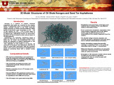
 |
Characterization of Pyrolysis Products from a Utah Green River Oil Shale by 13C NMR, GC/MS, and FTIR | 2013-10-14 | Pyrolysis; Utah; Green River; Oil Shale; GC/MS; FTIR; 33rd Oil Shale Symposium; Kerogen; Oil shale kerogen; 13C; NMR; TGA | |
| 3 |
 |
Clean and secure energy from domestic oil shale and oil sands resources: Quarterly progress report - April 2014-June 2014 | 2014 | domestic oil shale resources; domestic oil sands resources; ICSE; developing oil resources; CO2 management; utilization of oil shale and oil sands; liquid fuel production; in-situ thermal processing of oil shale | The Clean and Secure Energy from Domestic Oil Shale and Oil Sands Resources program, part of the research agenda of the Institute for Clean and Secure Energy (ICSE) at the University of Utah, is focused on engineering, scientific, and legal research surrounding the development of these resources in ... |
| 4 |
 |
Unconventional energy development in Utah | 2012-05-15 | ||
| 5 |
 |
Field guide to lacustrine and related nonmarine depositional environments in tertiary rocks, Uinta Basin, Utah | 1976-11 | lacustrine environments; nonmarine depositional environments; tertiary rocks | The lower part of the Tertiary System in the Uinta Basin of northeastern Utah and northwestern Colorado (fig. 1) reflects a series of very complex and variable forms of continental sedimentation in a basin of internal drainage. These complex forms represent the disruption of the Cretaceous depositio... |
| 6 |
 |
Atomistic modeling of oil shale kerogen and asphaltenes | 2010-04-28 | Kerogen is a mixture of organic chemical compounds that make up a portion of the organic matter in sedimentary rocks. It is insoluble in normal organic solvents because of the large molecular weight (upwards of several thousand Daltons). When heated in the Earth's crust (oil window ca. 60 ° - 120 �... | |
| 7 |
 |
Characterization of macromolecular structure elements from a Green River oil shale | 2013-10-14 | Macromolecular Structure; Green River; Oil Shale; 33rd Oil Shale Symposium; Golden, Colorado; Kerogen; Shale; Green River oil shale; Bitumen | This work is based upon work supported by the Department of Energy under Award Number DENT0005015. The views and opinions expressed herein do not necessarily state or reflect thoseof the United States Government or any agency thereof. |
| 8 |
 |
Effect of operating parameters on fired heater tube skin temperature measurement accuracy & the development of new improved tube skin thermocouple | 2022 | Refineries are often faced with challenges to meet production target, improve efficiency, process opportunity crudes with limited information on fouling characteristics etc. The common parameter that often becomes constraining are the tube skin temperatures which are critical in maintaining the inte... | |
| 9 |
 |
Part 999999 | |||
| 10 |
 |
Formation pathways of ethynyl-substituted and cyclopenta-fused polycyclic aromatic hydrocarbons | 2000 | formation pathways of aromatic hydrocarbons; aromatic hydrocarbons; ethynyl-substituted aromatic hydrocarbons; cyclopenta-fused polycyclic aromatic hydrocarbons; PAH; ethynyl-PAH | Two novel classes of polycyclic aromatic hydrocarbons (PAH), those with ethynyl substituents (ethynyl- PAH) and those with externally fused five-membered rings (cyclopenta-fused PAH or CP-PAH), have recently been identified in the products of a variety of fuels and combustion/pyrolysis environments.... |
| 11 |
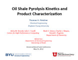 |
Oil shale pyrolysis kinetics and product characterization | 2012-05-15 | ||
| 12 |
 |
Part 9 | |||
| 13 |
 |
Part 999999 | |||
| 14 |
 |
Oil impregnated carbonate rocks of the Timpoweap Member Moenkopi Formation, Hurricane Cliffs area, Utah and Arizona | 1979 | Oil impregnated rocks; Hurricane Cliffs; Utah; Arizona; Timpoweap Member; Triassic Moenkopi Formation; Timpoweap Canyon; Hurricane, Utah | Oil impregnated rocks crop out at several localities near the Hurricane Cliffs in southwestern Utah and adjacent Arizona. The most significant petroliferous deposits occur in the Timpoweap Member of the Triassic Moenkopi Formation in Timpoweap Canyon and the Hurricane Cliffs south of Hurricane, Utah... |
| 15 |
 |
Earth Energy Resources, Inc. oil sands production in Utah: Continued development | 2009-02-27 | Oil Sand; Utah; Hydrocarbon Energy Environmental Gap; HEEG; Earth Energy; Oil sand production; Ophus Process; Oil sand deposits; Bitumen extraction; Oil sand mining; EER Spring Mine Site; Vernal, Utah | Overview of Earth Energy Resources, Inc.'s continuing oil sands development activities in Utah, presented at the 2009 Western U.S. Oil Sands Conference by D. Glen Snarr, President & Chief Financial Officer, Earth Energy Resources, Inc. |
| 16 |
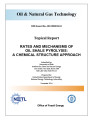 |
Rates and mechanisms of oil shale pyrolysis: A chemical structure approach | 2014-11 | Green River oil shale; oil and natural gas technology; oil shale pyrolysis; chemical structure of oil shale | Three pristine Utah Green River oil shale samples were obtained and used for analysis by the combined research groups at the University of Utah and Brigham Young University. Oil shale samples were first demineralized and the separated kerogen and extracted bitumen samples were then studied by a host... |
| 17 |
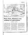 |
Plant starts, Athabasca now yielding its hydrocarbons | 1967-10-23 | synthetic crude; Athabasca oil sands; crude; strip mining | First synthetic crude from the Athabasca oil sands region of northeastern Alberta will reach the Toledo, Ohio, refinery of Sun Oil Co. in November. It will be an excellent grade of crude - high in gravity, free of sulfur and nitrogen. But nonetheless, it will have a strange background. Instead of be... |
| 18 |
 |
Parks and Recreation | 1973 | ||
| 19 |
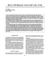 |
Heavy-oil deposit, Great Salt Lake, Utah | 1987 | heavy-oil deposit; Great Salt Lake; Neogene basins | The western portion of the Great Salt Lake contains two large Neogene basins, informally called the "North" and "South" basins. These basins are separated by an arch that trends northeast between Carrington Island and Fremont Island. Both basins are filled with Miocene, Pliocene, and Quaternary sedi... |
| 20 |
 |
Report on engineered measures to reduce the salinity differential between the north and south arms of the Great Salt Lake | 1999-12 | salinity reduction; PSOMAS; DFFSL | Procurement and Contract This report fulfills the requirements of the contract between the Utah Department of Natural Resources, Division of Forestry, Fire and State Lands (DFFSL), and PSOMAS. Procurement for this contract was handled under requisition number 560-01000000001, FY2000, and the effecti... |
| 21 |
 |
Closed loop flare control using a video imaging spectral radiometer | Video Imaging Spectral Radiometry (VISR) has emerged as the only practical method to directly and continuously monitor flare performance. The VISR method provides real time measurements of flare combustion efficiency (%) and a smoke index (0-10) at a 1-sec temporal resolution. In addition to these t... | ||
| 22 |
 |
A brief history of early mineral exploitation in the Uinta Basin | 1964 | Uinta Basin; Mining; Uintah Valley; Indian Reservation; Meeker; Utah; History of early mineral exploitation; Uintah Reservation; Gilsonite; Coal; Copper; Iron; Oil shale; Ozocerite; Wurtzilite; Oil; Asphalt; Ashley Creek; Hatchtown; Vernal; Fort Duchesne; Ouray Subagency | Early mining activities in the Uinta Basin can be summarized by saying that they included mining for gilsonite, coal, copper, iron, oil shale, ozocerite, wurtzilite, and oil and asphalt (under the placer mining laws). Of these minerals only coal and gilsonite were produced in commercially significan... |
| 23 |
 |
Clearing the Path | 2018-01 | Student success; University of Utah | A strategic student success agenda. |
| 24 |
 |
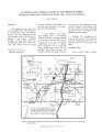
Reconnaissance study of bituminous sandstone deposits, Trans*Dirty Devil, Wayne and Garfield Counties, Utah | 1966-11 | bitumous sandstone deposits; Elaterite Basin; Teapot Rock | This report is the result of preliminary and reconnaissance investigations of the Elaterite Basin and Teapot Rock bituminous sandstone occurrences. Six samples were analyzed for their bitumen content and seven sections were measured in the Teapot Rock area. Up to 200 feet of varying degrees of satur... |
| 25 |
 |
UPEDLD user's manual | The UPEDLD system generates employment projections across designated broad occupation categories for specified regions and years. This system serves as a bridge between the REGION VIII employment-occupation detail and employment data produced from other models. |