TO
Filters: Collection: "ir_eua"
| Title | Date | Subject | Description | ||
|---|---|---|---|---|---|
| 1 |
 |
Reconnaissance study of bituminous sandstone deposits, Trans*Dirty Devil, Wayne and Garfield Counties, Utah | 1966-11 | bitumous sandstone deposits; Elaterite Basin; Teapot Rock | This report is the result of preliminary and reconnaissance investigations of the Elaterite Basin and Teapot Rock bituminous sandstone occurrences. Six samples were analyzed for their bitumen content and seven sections were measured in the Teapot Rock area. Up to 200 feet of varying degrees of satur... |
| 2 |
 |
Energy resources map of Utah (no. 68) | 1983-05 | Map 68; Utah; Energy Resources map; Gilsonite; Oil shale; Oil-impregnated rock; Geology; Oil and natural gas | |
| 3 |
 |
Road log no. 2 | 1963 | road log; geology of southwestern Utah | Road Log NO. 2 1.1 St. George, Utah, To Cedar City, Utah, Via Zion National Park and Cedar Breaks National Monument (216.9 Miles). |
| 4 |
 |
Ground-water flow and migration of hydrocarbons to the Lower Permian White Rim Sandstone, Tar Sand Triangle, southeastern Utah | 1995 | ground-water flow; migration of hydrocarbons; hydrocarbons; Lower Permian White Rim Sandstone; Tar Sand Triangle; heavy oil | The Lower Permian White Rim Sandstone in the Tar Sand Triangle of southeastern Utah contains an estimated 12.5-16 billion barrels of heavy oil. Despite the large size of the deposit, the source of its oil is unknown. This paper systematically discusses source rocks for this petroleum from the standp... |
| 5 |
 |
Oil-impregnated sandstone deposits Circle Cliffs Uplift, Utah | 1981-04 | oil-impregnated sandstone; Utah deposits; Circle Cliffs Uplift; Triassic Moenkopi Formation; oil-impregnated sandstone resource | One of the major oil-impregnated sandstone deposits in the United States is present on the Circle Cliffs uplift in an unnamed sandstone unit in the middle portion of the Triassic Moenkopi Formation. The deposit occurs on the west and east flanks of the uplift and is separated by an irregular barren ... |
| 6 |
 |
The oil resources in tar sand deposits in the United States | 1982 | oil resources; tar sand deposits; tar sand oil recovery processes | This report summarizes the data available at the Laramie Energy Technology Center. An effort was made to catalogue U.S. tar sand resources, identify U.S. and state maps showing tar sand deposits, and attempt to compare tar sand oil recovery processes. A review of the available data indicated there w... |
| 7 |
 |
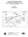
Tract summary report, Golden Corral combined hydrocarbon tract, Wayne County, Utah | 1982-10-06 | tract summary report; hydrocarbon tract; stratigraphy; structural geology; tar sand deposits; bitumen impregnated rock; bitumen | |
| 8 |
 |
Major tar sand deposits of Utah, United States: Recent field investigations | 1986-07-10 | tar sand deposits; field investigations; tar sand resource; resource evaluation | The results of field investigations at three major Utah tar sand deposits are presented along with representative core sections. A resource evaluation of the PR Spring deposit in the southeastern Uinta Basin includes stratigraphic cross sections and isopleth maps of significant reservoir engineering... |
| 9 |
 |
Evaluation of the Utah oil sand resource | 1976-08 | oil sand deposits; Utah oil sand; oil sand resource; Tar Sand Triangle; P. R. Spring; Sunnyside deposits; hydrocarbons; surface mining of oil sands | The three largest oil sand deposits in Utah, namely, the Tar Sand Triangle, the P.R. Spring, and the Sunnyside deposits, have been studied to contribute data relative to the surface and insitu mining of these deposits and to recommend research that should be conducted to develop the Utah oil sand re... |
| 10 |
 |
Diagenetic and burial history of the Lower Permian White Rim Sandstone in the Tar Sand Triangle, Paradox Basin, southeastern Utah | 1995 | Subsurface petrologic study and burial history reconstruction of the Lower Permian White Rim Sandstone in the Tar Sand triangle on the western edge of the Paradox Basin in southeastern Utah suggest that oil migrated into White Rim reservoirs after significant burial during the early Tertiary. Primar... | |
| 11 |
 |
Dilution centrifuging of bitumen froth from the hot water process for tar sand | 1983-05-17 | Patent; Dilution centrifuging; Bitumen froth; Tar sand; Naphtha-diluted bitumen froth | In the known operation wherein naphtha-diluted bitumen froth is pumped from a scroll-type centrifugal separator to a disc-type centrifugal separator, an improved pumping system is provided. The system comprises at least two centrifugal pumps in series, each operating preferably at an impellor tip sp... |
| 12 |
 |
Geology and petroleum resources of the major oil-impregnated sandstone deposits of Utah | 1979-08 | petroleum resources; oil-impregnated sandstone deposits | Near surface, oil-impregnated rock deposits in Utah are estimated to contain as much as 29 billion barrels of petroleum. Over fifty individual deposits have been identified, primarily through field mapping. Over 96 percent of the oil in place occurs in sandstone host rocks in six giant deposits. Fou... |
| 13 |
 |
Stratigraphy and origin of the Moenkopi Formation (Triassic) of southeastern Utah | 1973-01 | Moenkopi Formation; stratigraphy; regional stratigraphy of southeastern Utah | In southeastern Utah, the Triassic Moenkopi Formation is composed mainly of red and yellowish-gray siltstone, sandstone, mudstone, and limestone. Continuity of individual units is one of the characteristics of this formation and provides a basic for regional correlation. For the purpose of this stud... |
| 14 |
 |
Investigation of tar sand and heavy oil deposits of Utah for underground coal gasification applications | 1985-12 | tar sand; heavy oil deposits; underground coal gasification; UCG applications | A literature review was conducted to determine spatial and geological relationships between Utah's tar sand or heavy oil deposits and coal deposits and to evaluate these relationships in terms of suitability for underground coal gasification (UCG) applications. The investigation was undertaken as pa... |
| 15 |
 |
Analyses of oil extracted from oil-impregnated sandstone deposits in Utah | 1972-01 | This study, in progress from 1967 to 1970, is part of a systematic effort to find, map and sample Utah's oil-impregnated rock deposits. Samples were collected by ten individuals in field parties who examined oil-impregnated rock occurrences throughout the state. Samples 68-3A and 68-4A are from aban... | |
| 16 |
 |
Mineral management plan: Glen Canyon National Recreation Area--Arizona and Utah | 1980-03 | A General Management Plan (GMP) for Glen Canyon National Recreation Area was prepared during the period 1973 - 1979 and was approved on November 21, 1979, after it and an accompanying final environmental statement (FES 79-23) had been released to the public. That Plan called for the preparation of a... | |
| 17 |
 |
Basin-wide evaluation of the uppermost Green River Formation's oil-shale resource, Uinta Basin, Utah and Colorado | 2008 | Green River; Uinta Basin; Utah; Colorado; Crude oil; Green River Formation; Oil; Gas; Oil yield; Oil shale; Oil-shale thickness; Mahogany zone; R-7; Parachute Creek Member; Richness grade; Uintah County; Salt Lake Base Line and Meridian; BLM; U.S. Bureau of Land Management | Due to the recent increase in crude oil prices and concerns over diminishing conventional reserves, the Utah Geological Survey has reexamined the Uinta Basin's oil-shale resource, primarily in the Mahogany zone of the Green River Formation. Past assessments, the first conducted in 1964 and subsequen... |
| 18 |
 |
Potential hydrologic impacts of a tar-sand industry in 11 special tar sand areas in eastern Utah | 1983 | crude oil tar-sand deposits; U.S. Bureau of Land Management; Tar Sand Triangle area; hydrolic impact | About 93 percent of the Nation's estimated 30 billion barrels of crude oil in tar-sand deposits is in 11 areas in eastern Utah that were chosen for leasing by the U.S. Bureau of Land Management. The largest deposit, which is in the Tar Sand Triangle area, contains about 15 billion barrels of oil. Th... |
| 19 |
 |
Policy analysis of water availability and use issues for domestic oil shale and oil sands development: Topical Report: October 1, 2009 to March 31, 2010 | 2010-03 | oil shale/sands resources; energy source; unconventional fuels; water demands; water availability; domestic oil shale/sands development; topical report | Oil shale and oil sands resources located within the intermountain west represent a vast, and as of yet, commercially untapped source of energy. Development will require water, and demand for scarce water resources stands at the front of a long list of barriers to commercialization. Water requiremen... |
| 20 |
 |
Depositional setting and preliminary oil-shale resource potential, southwestern Uinta Basin, Utah | 1982 | Oil shale; Uinta Basin; Utah; Green River; Oil yield; Lake Uinta; Mohogany zone; Kerogen; Sheep Pass; Elko Basins; Nevada; Strawberry Structure; Strawberry Reservoir | This report characterizes the potential oil-shale resources underlying those lands west of the Green River in the southwestern Uinta Basin, Utah. The principal evaluation technique has been the calculation of oil yield from oil-well sonic and density log data available in this area. Subsurface corre... |
| 21 |
 |
Geologic summary report of the 1981 exploration program, Sunnyside Tar Sands project, Carbon County, Utah | 1982-02-19 | Geologic summary; exploration project; Sunnyside Tar Sands project; delta complex. | The 1981 Sunnyside exploration program consisted of: (1) diamond drilling of sixteen drill holes and logging of the core, and (2) initial geologic mapping in the northern area to better define the limits of the tar sands associated with the Sunnyside delta complex. In order to comprehend the geometr... |
| 22 |
 |
Utah data guide a newsletter for data users | 1998 | Utah's seven associations of government (AOGs)1 have produced these city and unincorporated area population projections for each year from 1997 through 2002 and for the years 2010 and 2020. These are consistent with the county population projections produced by the Governor's Office of Planning and ... | |
| 23 |
 |
Geologic summary report of the 1984 exploration program, Sunnyside Tar Sands project, Carbon County, Utah--volume 1 | 1985-06 | geologic summary; exploration program; tar sands; Sunnyside tar sand deposit. | The 1984 Sunnyside exploration program consisted of: (1) diamond drilling of fifteen drill holes, (2) logging of all core and (3) additional geological mapping in the north area to better define the limits of the tar sands associated with the Sunnyside delta complex. Both regional and detailed geolo... |
| 24 |
 |
Tar-sand resources of the Uinta Basin, Utah: A catalog of deposits | 1996-05 | tar sand; oil-impregnated sandstone; tar sand resources; solid hydrocarbon deposits; bitumous sandstone | Tar-sand, or oil-impregnated sandstone, deposits and occurrences of the Uinta Basin, Utah are summarized and presented. Twenty five tar-sand deposits/occurrences are reviewed with respect to geology, locations of bitumen saturated outcrops, land ownership, physiography, bitumen-analyses, development... |
| 25 |
 |
Geologic summary report of the 1982 exploration program, Sunnyside Tar Sands project, Carbon County, Utah | 1983-06-30 | geologic summary report; exploration program; Sunnyside Tar Sands project; tar sands; bituminous sandstone deposits | The Sunnyside tar sands are located within the southwest portion of the Uinta Basin and localized within a small delta complex that formed in Lake Uinta during early Tertiary time. The essence of the Sunnyside tar sands deposit is a sequence of laterally continuous sheet sands or stacked bituminous ... |