TO
Filters: Collection: "ir_eua"
| Title | Date | Subject | Description | ||
|---|---|---|---|---|---|
| 1 |
 |
The Navajo economic-demographic model a method for forecasting and evaluating alternative Navajo economic futures Volume 1: A technial description of the model | 1975 | In April 1975, the Four Corners Regional Commission extended a grant to the Navajo Tribe, through its Office of Program Development, to develop an increased planning and decision-making capability by producing the capacity of projecting the consequences of alternative Navajo economic futures. With t... | |
| 2 |
 |
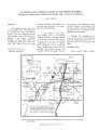
Geophysical report, seismograph survey, of the Asphalt Ridge prospect Uintah County, Utah | 1967-11 | Geophysical report; seismograph survey; Asphalt Ridge prospect. | Location and general information: The area designated as Asphalt Ridge, located directly southwest of the Ashley Creek oil field, is in the northeastern part of Uintah County, Utah, in T. 5 S. , R. 22 E. , and T. 6 S. , R. 21 E. Geologically, the area is situated on the north flank, and extends to t... |
| 3 |
 |
Road log no. 2 | 1963 | road log; geology of southwestern Utah | Road Log NO. 2 1.1 St. George, Utah, To Cedar City, Utah, Via Zion National Park and Cedar Breaks National Monument (216.9 Miles). |
| 4 |
 |
Oil-impregnated sandstones in Utah and Wayne Counties, Utah | 1972 | Thistle; Utah County; Jurassic sandstone; Thousand Lake Mountain; Wayne County; Oil-impregnated sediments; Asphalt-bearing Tertiary beds | Two little known occurrences of oil-impregnated sediments are discussed briefly. One is a fairly extensive area of asphalt-bearing Tertiary beds in the vicinity of Thistle, Utah County. The other is a very limited exposure of Jurassic sandstone permeated with dead oil on Thousand Lake Mountain in Wa... |
| 5 |
 |
Estimate of total, oil in place White Rocks Oil Properties Uintah county, Utah | 1961-12-09 | oil; petroleum recovery; heavy oil; tar; oil reserves; White Rocks Oil properties | Western Industries, Inc., is engaged in a project with the ultimate objective of recovering petroleum products from the "heavy oil" or "tar" bearing Navajo sandstone formation which is found at or near the surface on certain properties which they have acquired in Uintah County, Utah. Work on this pr... |
| 6 |
 |
The oil resources in tar sand deposits in the United States | 1982 | oil resources; tar sand deposits; tar sand oil recovery processes | This report summarizes the data available at the Laramie Energy Technology Center. An effort was made to catalogue U.S. tar sand resources, identify U.S. and state maps showing tar sand deposits, and attempt to compare tar sand oil recovery processes. A review of the available data indicated there w... |
| 7 |
 |
Energy resources map of Utah (no. 68) | 1983-05 | Map 68; Utah; Energy Resources map; Gilsonite; Oil shale; Oil-impregnated rock; Geology; Oil and natural gas | |
| 8 |
 |
Facts in Brief | |||
| 9 |
 |
Facts in Brief | |||
| 10 |
 |
Facts in Brief | |||
| 11 |
 |
Facts in Brief | |||
| 12 |
 |
Taking another look at Utah's tar sand resources | 2009 | tar sand; tar sand resources; unconventional energy resource; alternate energy resource; oil impregnated sandstone; oil sand; bitumous sandstone; energy resource | Recent increases in the price of crude oil have sparked renewed interest in unconventional energy resources, including Utah s tar sands. Tar sands (also called oil-impregnated sandstones, oil sands, and bituminous sandstones) are, as the names imply, sandstones that are saturated or filled with blac... |
| 13 |
 |
Geologic summary report of the 1990 exploration program, Sunnyside Tar Sands project, Carbon County, Utah--volume 1 | 1991-02-28 | geologic summary; exploration program; Sunnyside tar sands project; tar sand; regional, engineering geology. | This 1990 report is a supplement to the extensive 1989 report. This 1990 report concentrates on results of the following four categories: (1) regional geology and engineering geology needed to investigate the feasibility of conveyor routes that will bring the tar sand ore down from the Roan Cliffs t... |
| 14 |
 |
Brief history and recent developments in tar sand deposits of Uinta Basin | 1985 | Commercial production of oil from bituminous sandstones, more commonly referred to as "Tar sands", is considered by many to be a viable project. These so-called "heavy oil" deposits represent a very considerable reserve of oil for the future. The Uinta basin is Mother Nature's storehouse of exotic b... | |
| 15 |
 |
Mineral management plan: Glen Canyon National Recreation Area--Arizona and Utah | 1980-03 | A General Management Plan (GMP) for Glen Canyon National Recreation Area was prepared during the period 1973 - 1979 and was approved on November 21, 1979, after it and an accompanying final environmental statement (FES 79-23) had been released to the public. That Plan called for the preparation of a... | |
| 16 |
 |
United States tar sands | 1982 | U.S. tar sands; tar sands; Interstate Oil Compact Commission | The term 'Tar Sands' is a catch-all misnomer that includes asphaltic and oil-impregnated sandstones, siltstones, and other elastics and even limestones and other carbonates - but not "oil shales" or man-made paving material. A press agent might entitle this paper "OIL, the Overlooked Billions of Bar... |
| 17 |
 |
Tract summary report, Golden Corral combined hydrocarbon tract, Wayne County, Utah | 1982-10-06 | tract summary report; hydrocarbon tract; stratigraphy; structural geology; tar sand deposits; bitumen impregnated rock; bitumen | |
| 18 |
 |
Major tar sand deposits of Utah, United States: Recent field investigations | 1986-07-10 | tar sand deposits; field investigations; tar sand resource; resource evaluation | The results of field investigations at three major Utah tar sand deposits are presented along with representative core sections. A resource evaluation of the PR Spring deposit in the southeastern Uinta Basin includes stratigraphic cross sections and isopleth maps of significant reservoir engineering... |
| 19 |
 |
Ground-water flow and migration of hydrocarbons to the Lower Permian White Rim Sandstone, Tar Sand Triangle, southeastern Utah | 1995 | ground-water flow; migration of hydrocarbons; hydrocarbons; Lower Permian White Rim Sandstone; Tar Sand Triangle; heavy oil | The Lower Permian White Rim Sandstone in the Tar Sand Triangle of southeastern Utah contains an estimated 12.5-16 billion barrels of heavy oil. Despite the large size of the deposit, the source of its oil is unknown. This paper systematically discusses source rocks for this petroleum from the standp... |
| 20 |
 |
Oil-impregnated sandstone deposits Circle Cliffs Uplift, Utah | 1981-04 | oil-impregnated sandstone; Utah deposits; Circle Cliffs Uplift; Triassic Moenkopi Formation; oil-impregnated sandstone resource | One of the major oil-impregnated sandstone deposits in the United States is present on the Circle Cliffs uplift in an unnamed sandstone unit in the middle portion of the Triassic Moenkopi Formation. The deposit occurs on the west and east flanks of the uplift and is separated by an irregular barren ... |
| 21 |
 |
Reconnaissance study of bituminous sandstone deposits, Trans*Dirty Devil, Wayne and Garfield Counties, Utah | 1966-11 | bitumous sandstone deposits; Elaterite Basin; Teapot Rock | This report is the result of preliminary and reconnaissance investigations of the Elaterite Basin and Teapot Rock bituminous sandstone occurrences. Six samples were analyzed for their bitumen content and seven sections were measured in the Teapot Rock area. Up to 200 feet of varying degrees of satur... |
| 22 |
 |
Analyses of oil extracted from oil-impregnated sandstone deposits in Utah | 1972-01 | This study, in progress from 1967 to 1970, is part of a systematic effort to find, map and sample Utah's oil-impregnated rock deposits. Samples were collected by ten individuals in field parties who examined oil-impregnated rock occurrences throughout the state. Samples 68-3A and 68-4A are from aban... | |
| 23 |
 |
Tar-sand resources of the Uinta Basin, Utah: A catalog of deposits | 1996-05 | tar sand; oil-impregnated sandstone; tar sand resources; solid hydrocarbon deposits; bitumous sandstone | Tar-sand, or oil-impregnated sandstone, deposits and occurrences of the Uinta Basin, Utah are summarized and presented. Twenty five tar-sand deposits/occurrences are reviewed with respect to geology, locations of bitumen saturated outcrops, land ownership, physiography, bitumen-analyses, development... |
| 24 |
 |
Oil impregnated carbonate rocks of the Timpoweap Member Moenkopi Formation, Hurricane Cliffs area, Utah and Arizona | 1979 | Oil impregnated rocks; Hurricane Cliffs; Utah; Arizona; Timpoweap Member; Triassic Moenkopi Formation; Timpoweap Canyon; Hurricane, Utah | Oil impregnated rocks crop out at several localities near the Hurricane Cliffs in southwestern Utah and adjacent Arizona. The most significant petroliferous deposits occur in the Timpoweap Member of the Triassic Moenkopi Formation in Timpoweap Canyon and the Hurricane Cliffs south of Hurricane, Utah... |
| 25 |
 |
Utah data guide a newsletter for data users | 1998 | Utah's seven associations of government (AOGs)1 have produced these city and unincorporated area population projections for each year from 1997 through 2002 and for the years 2010 and 2020. These are consistent with the county population projections produced by the Governor's Office of Planning and ... |