TO
Filters: Collection: "ir_eua"
| Title | Date | Subject | Description | ||
|---|---|---|---|---|---|
| 151 |
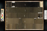 |
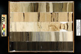
Skyline 16: SW SW sec. 10 11S 25E Uintah County, Utah. Box 91 Depth: 920.0 - 930.0 ft. | 2015-07 | core sample; Skyline 16; box 91; Green River Formation | Core sample photograph by the Utah Geological Survey at the University of Utah, and the Utah Core Research Center. Skyline 16: SW SW sec. 10 11S 25E Uintah County, Utah. Box 91 Depth: 920.0 - 930.0 ft. |
| 152 |
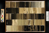 |
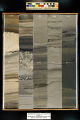
Skyline 16: SW SW sec. 10 11S 25E Uintah County, Utah. Box 92 Depth: 930.0 - 940.0 ft. | 2015-07 | core sample; Skyline 16; box 92; Green River Formation | Core sample photograph by the Utah Geological Survey at the University of Utah, and the Utah Core Research Center. Skyline 16: SW SW sec. 10 11S 25E Uintah County, Utah. Box 92 Depth: 930.0 - 940.0 ft. |
| 153 |
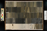 |
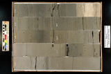
Skyline 16: SW SW sec. 10 11S 25E Uintah County, Utah. Box 93 Depth: 940.0 - 950.0 ft. | 2015-07 | core sample; Skyline 16; box 93; Green River Formation | Core sample photograph by the Utah Geological Survey at the University of Utah, and the Utah Core Research Center. Skyline 16: SW SW sec. 10 11S 25E Uintah County, Utah. Box 93 Depth: 940.0 - 950.0 ft. |
| 154 |
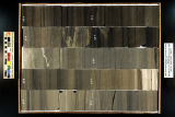 |
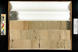
Skyline 16: SW SW sec. 10 11S 25E Uintah County, Utah. Box 94 Depth: 950.0 - 960.0 ft. | 2015-07 | core sample; Skyline 16; box 94; Green River Formation | Core sample photograph by the Utah Geological Survey at the University of Utah, and the Utah Core Research Center. Skyline 16: SW SW sec. 10 11S 25E Uintah County, Utah. Box 94 Depth: 950.0 - 960.0 ft. |
| 155 |
 |
Skyline 16: SW SW sec. 10 11S 25E Uintah County, Utah. Box 95 Depth: 960.0 - 970.0 ft. | 2015-07 | core sample; Skyline 16; box 95; Green River Formation | Core sample photograph by the Utah Geological Survey at the University of Utah, and the Utah Core Research Center. Skyline 16: SW SW sec. 10 11S 25E Uintah County, Utah. Box 95 Depth: 960.0 - 970.0 ft. |
| 156 |
 |
Skyline 16: SW SW sec. 10 11S 25E Uintah County, Utah. Box 96 Depth: 970.0 - 980.0 ft. | 2015-07 | core sample; Skyline 16; box 96; Green River Formation | Core sample photograph by the Utah Geological Survey at the University of Utah, and the Utah Core Research Center. Skyline 16: SW SW sec. 10 11S 25E Uintah County, Utah. Box 96 Depth: 970.0 - 980.0 ft. |
| 157 |
 |
Skyline 16: SW SW sec. 10 11S 25E Uintah County, Utah. Box 97 Depth: 980.0 - 990.0 ft. | 2015-07 | core sample; Skyline 16; box 97; Green River Formation | Core sample photograph by the Utah Geological Survey at the University of Utah, and the Utah Core Research Center. Skyline 16: SW SW sec. 10 11S 25E Uintah County, Utah. Box 97 Depth: 980.0 - 990.0 ft. |
| 158 |
 |
Skyline 16: SW SW sec. 10 11S 25E Uintah County, Utah. Box 98 Depth: 990.0 - 1000.0 ft. | 2015-07 | core sample; Skyline 16; box 98; Green River Formation | Core sample photograph by the Utah Geological Survey at the University of Utah, and the Utah Core Research Center. Skyline 16: SW SW sec. 10 11S 25E Uintah County, Utah. Box 98 Depth: 990.0 - 1000.0 ft. |
| 159 |
 |
Skyline 16: SW SW sec. 10 11S 25E Uintah County, Utah. Box 99 Depth: 1000.0 - 1006.25 ft. | 2015-07 | core sample; Skyline 16; Green River Formation; box 99 | Core sample photograph by the Utah Geological Survey at the University of Utah, and the Utah Core Research Center. Skyline 16: SW SW sec. 10 11S 25E Uintah County, Utah. Box 99 Depth: 1000.0 - 1006.25 ft. |
| 160 |
 |
Facts in Brief | |||
| 161 |
 |
Facts in Brief | |||
| 162 |
 |
1976 Statistical Abstract of Utah | 1976-01 | The Bureau of Economic and Business Research presents the seventh edition of the Statistical Abstract of Utah, 1976, the Bicentennial Edition. The basic goal of this document is to bring together under one cover the data most often requested in a readily available format. During an average year, g... | |
| 163 |
 |
Required Documentation 1.1: Institutional Mission Statement (2006) | The University of Utah 2006 Self-Study Required Documentation: Standards 1-4. Standard 1 Section 1: Institutional Mission Statement. | ||
| 164 |
 |
About the University | |||
| 165 |
 |
AR_Campus Map | |||
| 166 |
 |
Program: Res-Alloc | This program allocates residentiary employment to subareas, using input SPINT matrices. The program may be run batch or interactively; in interactive mode, the user is prompted for input. All input, whether keyed in from the terminal or edited into batch runstreams, is entered in free-format (lists ... | ||
| 167 |
 |
Statistical Abstract of Utah 1973 | 1973-02 | The Bureau of Economic and Business Research presents the sixth edition of the Statistical Abstract of Utah, 1973. The basic goal of this document is to bring together under one cover the data most often requested in a readily available format. During an average year, government agencies, business f... | |
| 168 |
 |
Administration & Faculty | |||
| 169 |
 |
AQ_Administration and Faculty | |||
| 170 |
 |
Facts in Brief | |||
| 171 |
 |
Facts in Brief | |||
| 172 |
 |
Facts in Brief | |||
| 173 |
 |
Research and information needs for management of tar sands development | 1983 | tar sands management; research needed; tar sands | The purpose of this report is to review the research needed to support the regulatory and managerial role of the agencies in the development of tar sands resources. The material reviewed in preparation for this report was assembled and presented at the Workshop on Research Needs for the Management o... |
| 174 |
 |
AP_Administration & Faculty | |||
| 175 |
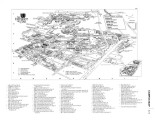 |
Campus Map |