TO
Filters: Collection: "ir_eua"
| Title | Date | Subject | Description | ||
|---|---|---|---|---|---|
| 151 |
 |
Chapter 17 | |||
| 152 |
 |
Salt Lake area transportation study: volume I current travel inventory | 1963-11 | A major element of this study was the review of current travel patterns generated by the 394,000 residents of the Salt Lake area as determined from a 1960 comprehensive origin-destination survey which was conducted by the Department of Highways. Supplemental studies covered commercial vehicle m... | |
| 153 |
 |
Colorful Gilson did more than promote gilsonite | 1996-03 | The following article from The Times-Independent in Moab pays tribute to the man for whom Gilsonite is named. Utah's American Gilsonite Company traces its roots to Sam Gilson. | |
| 154 |
 |
Photos | |||
| 155 |
 |
Strategic Monitoring of Underground Coal Gasification | 2011-03-23 | strategic monitoring; Underground Coal Gasification; process monitoring; groundwater monitoring; LLNL; UCG | 6th Annual International Conference & Workshop on Underground Coal Gasification, 23rd - 24th March 2011 |
| 156 |
 |
Sunnyside Special Tar Sand Area site specific analysis Sunnyside no. 8 tract: Moab District, Price River Resource Area | 1983-03 | Sunnyside Special Tar Sand Area; site specific analysis; Sunnyside no. 8 tract; STSA; tar sand extraction | The Sunnyside No. 8 Tract is in the southern part of the Sunnyside Special Tar Sand Area (STSA) in Carbon County, Utah. The tract is located about 27 miles east of Price (See Maps 1 and 2 in Appendix I). The legal description and ownership are shown in Table 1. |
| 157 |
 |
Chapter 7 | |||
| 158 |
 |
Surface tar-sand deposits in California | 1987 | surface tar-sand deposits; tar sand; surface tar sand; California; oil seeps; stratigraphy; tar sand deposit structure | Tar sand deposits and oil seeps have been known in California for more than a century and were used in the exploration for many of California's largest oil fields. Sixty deposits visited by this writer yielded 24 deposits totaling 5.27 billion barrels of oil in place and another 36 estimated at 1-2 ... |
| 159 |
 |
Final report on 1989 update of the computerized geologic model to include the 1988 drill hole data Sunnyside Tar Sands project Sunnyside, Utah | 1989-07 | computerized geologic model; 1988 drill hole data; Sunnyside Tar Sands project; geologic resources | In May 1989, Rozelle Consulting Services (RCS) was requested by Amoco Corporation (Amoco) to submit a proposed scope of work for updating the 1987 computerized geologic model of the Sunnyside Tar Sands deposit (Figure 1-1 and 1-2) to include the drill hole data that was completed in 1988 by Amoco. T... |
| 160 |
 |
Digitized log file, API Number 4301333379 | 2009 | This log was digitized by the Utah Geological Survey from image files (.tiff) compiled by the Utah Division of Oil, Gas, and Mining | |
| 161 |
 |
Oil shale: An introduction | 2008-11-13 | oil shale; oil shale resources; mahogany shale; oil shale production | Presentation given in the Utah Oil Shale Resources and Technology Update, on November 13, 2008, in Salt Lake City, Utah. |
| 162 |
 |
Petrographic criteria for recognition of lacustrine and fluvial sandstone, P.R. Spring oil-impregnated sandstone area, southeast Uinta Basin, Utah | 1971-06 | oil; lacustrine sandstone; fluvial sandstone; Petrographic criteria | Reserve estimates indicate about 3.7 billion barrels of oil in place in the P. R. Spring area, most of which is in lacustrine sandstone of the Garden Gulch and Parachute Creek members of the Green River Formation (Eocene). Fluvial sandstone bodies in the Wasatch Formation (Paleocene-Eocene) produce ... |
| 163 |
 |
Association of uranium and other metals with crude oil, asphalt, and petroliferous rock | 1954-10 | uranium; crude oil; asphalt; petroliferous rock | Some crude oil, natural asphalt, and petroliferous rock are appreciably radioactive, but little is known about the actual uranium content and the chemical nature of the uranium compound or compounds in these materials. Semiquantitative spectrographic analyses of the ash of 29 samples of crude oil, 2... |
| 164 |
 |
Gilsonite and related hydrocarbons of the Uinta Basin, Utah | 1949 | glisonite; hydrocarbons; Uinta Basin; kerogen; bitumen | Hydrocarbons are important in the present study for two reasons: ( 1) An understanding of their nature and origin may lead to a better understanding of the oil possibilities in the area. (2) From gilsonite, kerogen, and associated bituminous substances there may be fractionated many still-undiscover... |
| 165 |
 |
Sunnyside Special Tar Sand Area site specific analysis Sunnyside no. 3 tract: Moab District, Price River Resource Area | 1983-03 | Sunnyside Special Tar Sand Area; STSA; site analysis; site specific analysis; Sunnyside no. 3 tract; tar sand extraction | The Sunnyside No. 3 Tract is in the west central part of the Sunnyside Special Tar Sand Area (STSA) in Carbon County, Utah. The tract is located about 24 miles east of Price (See Maps 1 and 2 in Appendix I). The legal description and ownership are shown in Table 1. |
| 166 |
 |
Geochemical analysis of various crude oils Uinta Basin, Utah | 1988-12-01 | geochemical analysis; crude oils; Uinta Basin. | |
| 167 |
 |
List of SERDP publications and presentations | 2010 | SERDP; SERDP publications; SERDP presentations | Bibliography of SERDP publications |
| 168 |
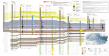 |
North-South core-based cross section through the middle to upper Green River Formation, Uinta Basin, Utah - Plate 2 | 2014 | oil shale; economic oil shale; oil shale zone; cross section; Green River Formation; well log; core log | The top of economic oil shale was picked at the top of the lower R-8 zone (top of the Big Three rich oil shale beds). This zone was selected to avoid the abundant saline minerals found in the overlaying saline zone, which often contains high-TDS water. If saline minerals (and high-TDS water) do not ... |
| 169 |
 |
West-East core-based cross section through the middle to upper Green River formation, Uinta Basin, Utah - Plate 1 | 2014 | well log; well log cross section; economic oil shale; Mahogany zone; Green River Formation | Conclusions/observations from west-east cross section: The top of economic oil shale was picked at the top of the lower R-8 zone (top of the Big Three rich oil shale beds). This zone was selected to avoid the abundant saline minerals found in the overlaying saline zone, which often contains high-TDS... |
| 170 |
 |
Uncertainty analysis of thermocouple measurements used in normal and abnormal thermal environment experiments at Sandia's Radiant Heat Facility and Lurance Canyon Burn Site | 2004-04 | thermocouple measurements; thermal environment experiment; Sandia's Radiant Heat Facility; Lurance Canyon Burn Site; thermocouple data. | It would not be possible to confidently qualify weapon systems performance or validate computer codes without knowing the uncertainty of the experimental data used. This report provides uncertainty estimates associated with thermocouple data for temperature measurements from two of Sandia's large-sc... |
| 171 |
 |
Basin-wide evaluation of the uppermost Green River Formation's oil-shale resource, Uinta Basin, Utah and Colorado | 2008 | Green River; Uinta Basin; Utah; Colorado; Crude oil; Green River Formation; Oil; Gas; Oil yield; Oil shale; Oil-shale thickness; Mahogany zone; R-7; Parachute Creek Member; Richness grade; Uintah County; Salt Lake Base Line and Meridian; BLM; U.S. Bureau of Land Management | Due to the recent increase in crude oil prices and concerns over diminishing conventional reserves, the Utah Geological Survey has reexamined the Uinta Basin's oil-shale resource, primarily in the Mahogany zone of the Green River Formation. Past assessments, the first conducted in 1964 and subsequen... |
| 172 |
 |
Sulphur isotope abundances in petroleum and associated materials | 1958-11 | sulphur isotope; petroleum; isotopes of sulphur; sulphur isotope abundances; treatment of oil samples | A study has been made of the sulphur isotope ratios for petroleum from many different oil fields in the United States and Canada. The S34/S32 ratio for petroleum varies by about 4.5 per cent as compared with a total spread of about 9 per cent for terrestrial sulphur. The single large oil pools appea... |
| 173 |
 |
Libraries and Museums, Research and Service Agencies | |||
| 174 |
 |
Libraries and Museums, Research and Service Agencies | |||
| 175 |
|
University Faculty and Administration, Index |